


![]()
You are here
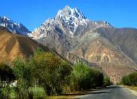
Glaciers of Shugnan Range.

Book travel in Tajikistan.
“I travel not to go anywhere, but to go. I travel for travel's sake. The great affair is to move”
Robert Louis Stevenson «Travels with a Donkey in the Cevennes».
Travel options in Tajikistan.
The Shugnansky ridge is located on the territory of the Rushansky district of the Gorno-Badkhshan Autonomous Region. Located in the interfluve of the rivers Gunt and Shahdara, stretching into latitudinal direction. Its western part is a high (4200 - 4500 meters above sea level) elevated lake plateau, above which surrounding peaks rise 500 - 700 meters above sea level.
To the northeast, the height of the ridge increases to 5700 meters above sea level (Skalisty peak). On the Shugnan ridge there are 386 glaciers with a total area of 150.3 square kilometers. Icing is more significant on the central section of the ridge, less dissected.
Glaciers have small slopes, wide and moraine-free short parts. Most of the glaciation area belongs to the valley glaciers. (72%), but there are also many slope glaciers. The largest is the Varschids Valley Glacier with an area of 7.5 square kilometers.
The total area of Shugnan range glaciation is about 150 square kilometers.
The largest glaciers of the Shugnan Range.
The Warsides Glacier, 6.8 kilometers long, covers an area of 5.8 square kilometers, is located at an altitude of 4380 to 5600 meters above sea level, belongs to the Varshidzdar River Basin.
The Rog Glacier, with a length of 4.4 kilometers, an area of 3.0 square kilometers, located at an altitude of 4540 to 5400 meters above sea level, belongs to the Pishdara River Basin.
Glacier 510, with a length of 6.8 kilometers, an area of 5.8 square kilometers, located at an altitude of 3780 to 5500 meters above sea level, belongs to the basin of the Akmamadar River.
Glacier 736, with a length of 3.8 kilometers, an area of 2.1 square kilometers, located at an altitude of 4680 to 5650 meters above sea level, belongs to the tributary of the Ayrang River.
Glacier 553, with a length of 3.6 kilometers, an area of 4.8 square kilometers, located at an altitude of 4340 to 5140 meters above sea level, belongs to the basin of the Rivakdara River.
Glacier 508, with a length of 3.6 kilometers, an area of 1.3 square kilometers, located at an altitude of 3780 to 5450 meters above sea level, belongs to the basin of the tributary of the Akmamadar River.
Glacier 536, with a length of 3.4 kilometers, an area of 2.2 square kilometers, located at an altitude of 4000 to 5100 meters above sea level, belongs to the basin of the tributary of the Vodzhdara River.
Glacier 519, with a length of 3.4 kilometers, an area of 1.3 square kilometers, located at an altitude of 4260 to 5200 meters above sea level, belongs to the basin, a tributary of the Gunt River.
Glacier 538, with a length of 3.4 kilometers, an area of 0.8 square kilometers, located at an altitude of 3420 to 5200 meters above sea level, belongs to the basin, a tributary of the Vodzhdara River.
Glacier 703, with a length of 3.2 kilometers, an area of 2.2 square kilometers, located at an altitude of 4480 to 5300 meters above sea level, belongs to the Drumdara river basin.
Glacier 577, with a length of 3.1 kilometers, an area of 2.5 square kilometers, located at an altitude of 4560 to 4900 meters above sea level, belongs to the basin of the Zirgozdar River.
Glacier 727, with a length of 3.0 kilometers, an area of 1.1 square kilometers, located at an altitude of 4760 to 4760 meters above sea level, belongs to the basin of the Nemoye River.
Authority:
"Glaciers." L.D. Dolgushin, G.B. Osipova. Series "Nature of the world." Moscow, the publishing house "Thought". 1989.