


![]()
You are here
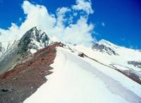
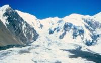
Glaciers of Shakhdarinsky ridge.
Class trip in Tajikistan.
“The real voyage of discovery consists not in seeking new landscapes, but in having new eyes”
Marcel Proust.
Business and leisure trips in Tajikistan.
Shahdarinsky Range is located north of the Pyanj River, in the southwestern part of the Pamirs in the Roshtkala and Ishkashim regions of the Gorno-Badakhshan Autonomous Region in southern Tajikistan. The Shakhdarinsky ridge extends in the southwestern part of the Pamir, from Mayakovsky peak at a height of 6,096 meters above sea level in the west to the Matz pass at a height of 4,450 meters above sea level, which separates it from the South Alichursky ridge in the east.
In the south, in the deep valley of the Pyanj River, it is separated from the Hindu Kush mountain ranges. The average height of the Shakhdara ridge is 5450 meters above sea level, the highest point is Karl Marx peak at a height of 6726 meters above sea level.
The southern slope of the ridge is deeply dissected by narrow gorges; its relative height above the Panj valley is 2500 - 2700 meters above sea level. Along the foot of the northern slope of the ridge stretches a wide plateau-like surface, sloping inclined toward the valley of the Shahdary River.
Snow peaks and rocky peaks of the main watershed of 1000 - 2000 meters rise above this surface. There are 311 glaciers on the Shakhdara ridge with a total area of 269 square kilometers. The glaciation of the southern slope is almost twice as large as the glaciation of the north, and the glaciers on it are larger.
The shallow glaciers of the northern slope are more numerous.On the southern slope of 130 glaciers with an area of 171.2 square kilometers. 84% of the glaciation area of this slope falls on the glaciers of the valleys.
The largest valley and complex valley glaciers are located in the area of Karl Marx peaks at a height of 6726 meters above sea level and Engels peak at a height of 6510 meters above sea level. These are the Sary-Shitharv, Nishgar and other glaciers.
The firn areas of these glaciers are on the slopes of the peaks, and the flat gentle parts of the glaciers descend through the valleys to 5200 - 5400 meters above sea level. The tributaries flowing into the lower parts of the glaciers are steep and form icefalls.
The surface of the glaciers is clean, complicated by ice crystals, sometimes reaching the height of human growth. On the northern slope of the Shakhdara ridge 181 glaciers with an area of 97.8 kilometers square.
Due to the steepness of the crest of the ridge, glaciers are small here. Both in quantity and in area, glaciers of the valleys prevail (50% of the total and 75% of the total area). Slope glaciers are the second largest in size and area, and caravans are the third.
More than half of all glaciers are smaller than 0.5 square kilometers, and the area of the largest glacier, Naspar, located under the walls of Engels Peak, is 5.1 square kilometers. The second largest on the northern slope, the Karl Marx Glacier (4.7 kilometers long, 4.9 square kilometers) lies at the bottom of a vast circus on the slope of Karl Marx Peak.
Total area of glaciation of Shakhdara range is about 270 square kilometers.
Largest glaciers of Shahdara range and its spur Badomdar
The Zugwand Glacier is 7.9 kilometers long, with an area of 6.0 square kilometers, located at an altitude of 4,500 to 6,700 meters above sea level, belongs to the Zugvand River Basin.
The Nashgar Glacier, with a length of 7.2 kilometers, an area of 8.0 square kilometers, is located at an altitude of 4760 to 6450 meters above sea level, belongs to the Nashgar River Basin.
Glacier 256 with a length of 7.2 kilometers, an area of 5.0 square kilometers, located at an altitude of 4,500 to 6,500 meters above sea level, belongs to a tributary of the Nashgar river basin.
Casvir Glacier is 6.9 kilometers long, with an area of 6.0 square kilometers, located at an altitude of 4280 to 5650 meters above sea level, belongs to the Casvir River Basin.
Glacier 177 with a length of 6.3 kilometers, an area of 11.2 square kilometers, located at an altitude of 5200 to 5600 meters above sea level, belongs to the Daray-Darshai River Basin.
Glacier 169 with a length of 6.2 kilometers, an area of 6.9 square kilometers, located at an altitude of 4660 to 5600 meters above sea level, belongs to the Ambarku river basin.
Glacier 181 with a length of 6.2 kilometers, an area of 6.9 square kilometers, located at an altitude of 4,500 to 5,640 meters above sea level, belongs to the basin of the tributary of the Daray-Darshai River.
Glacier 158 with a length of 5.2 kilometers, an area of 3.4 square kilometers, located at an altitude of 4900 to 5300 meters above sea level, belongs to the basin, a tributary of the Daray-Imast River.
5.1 km long Vnukut Glacier, an area of 4.4 square kilometers, located at an altitude of 4700 to 5800 meters above sea level, belongs to the Vnukut River Basin.
5.0 km long Saryshithavr Glacier, an area of 9.4 square kilometers, is located at an altitude of 4760 to 6140 meters above sea level, belongs to the Saryshithavr River Basin.
5.0 km long Kalbuk Glacier, an area of 7.6 square kilometers, is located at an altitude of 4760 to 5200 meters above sea level, belongs to the basin of the Daray-Darshai River tributary.
4.9-km-long Mionku Glacier, an area of 6.1 square kilometers, is located at an altitude of 4,500 to 5,640 meters above sea level, belongs to the Daray-Darshai River tributary basin.
4.8 km long Hanzek Glacier, an area of 2.8 square kilometers, is located at an altitude of 4730 to 5800 meters above sea level, belongs to the Hansek River Basin.
Glacier 286, 4.7 kilometers long, 8.5 square kilometers in area, located at an altitude of 4540 to 5950 meters above sea level, belongs to the Akba River Basin.
Karl Marx Glacier is 4.7 kilometers long, with an area of 4.9 square kilometers, located at an altitude of 4250 to 6726 meters above sea level, belongs to the Shabai River Basin.
Glacier 257 with a length of 4.7 kilometers, an area of 1.6 square kilometers, located at an altitude of 4550 to 6100 meters above sea level, belongs to the basin of a tributary of the Nishgar River.
Kishti-Jarob Glacier is 4.3 kilometers long, covering an area of 4.3 square kilometers, located at an altitude of 4600 to 5500 meters above sea level, and belongs to the Kishti-Jarob River Basin.
Yamghin Glacier is 4.3 kilometers long, with an area of 3.4 square kilometers, located at an altitude of 4680 to 5800 meters above sea level, belongs to the Yamgin River Basin.
Medyr Glacier is 4.2 kilometers long, with an area of 4.2 square kilometers, located at an altitude of 5120 to 5500 meters above sea level, belongs to the Medyr River Basin.
Geographical coordinates of Shakhdara Range: N37°06'24.12" E72°15'37.57"
Authority:
"Glaciers." L.D. Dolgushin, G.B. Osipova. Series "Nature of the world." Moscow, the publishing house "Thought". 1989.
Photos by
Alexander Petrov.