


![]()
You are here
Great Besshatyr burial mound.

Walks on Altyn-Emel park.
"In the bluish distance, where the last visible hill merged with the mist, nothing stirred; the guard and burial mounds, here and there towering above the horizon and the boundless steppe, looked stern and dead. In their stillness and silence, one could sense the centuries and their complete indifference to man. Another thousand years will pass, billions of people will die, and they will still stand as they stood, showing no regret for the dead, no interest in the living, and not a soul will know why they stand or what steppe secret they hide beneath them."
A.P. Chekhov. "Happiness." Dedicated to Ya.P. Polonsky.
Beshatyr burial mound excursion.
Great Besshatyr burial mound is located at an altitude of 674 m. a. s. l., is located in southwestern part of Sholak foothills, 4.1 kilometers from right bank of Ili River delta, 27.8 kilometers east and slightly north of Cordon No. 1, 50.5 kilometers southwest of village of Basshy, 4 kilometers north and slightly east of beginning of Shylbyr Gorge, within Altyn-Emel Nature Park, in Kerbulak District of Zhetysu Region.
Architecture of Besshatyr burial mound.
Each burial mound represents a complete architectural structure not only from its exterior but also in the complexity of its interior. Moreover, it can be said with certainty that each large kurgan is a unique architectural ensemble, consisting of a complex of several distinct structures that complement each other within the enormous mounds.
The links and parts of this complex are ring-shaped menhir structures, stone walls and stonework, underground passages, and so on. Overall, these structures create the impression of not just burial mounds, but monuments of ancient architecture erected to perpetuate the memory of leaders and exalt the glory and power of the tribe.
Below, we provide a full description of each large and excavated medium and small burial mound.
Description of Large Besshatyr burial mound.
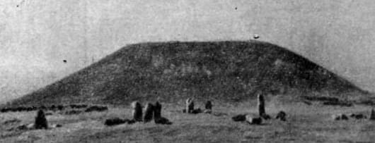
Large Besshatyr burial mound is located in the northeastern part of the burial ground. It is the largest burial mound, majestically rising above the others. Its diameter is 104 meters, and its average height is 15 meters. The best-preserved side of the mound reaches 17 meters in height.
The mound is shaped like a truncated cone, with a flat top measuring 32 meters in diameter. The mound's stone covering at its base is tightly packed in several rows, creating the impression of a plinth upon which the mound rests. On the northern and southern sides of the mound, depressions (2 meters wide) descending downwards are visible.
The southern depression, near the mound's floor, ends in a flat mound of rubble, 20 meters in diameter and 2 meters high. The mound is surrounded by a 2-meter-wide, 50-60 cm-high stone rampart for a distance of 5-7 meters. In 1961, we cleared a 35-meter-long section of the rampart to determine whether it was the remains of a collapsed stone wall.
The excavation did not confirm this assumption; no remains of masonry were found. Thus, it became clear that the monument's builders themselves deliberately constructed a surrounding rampart, but at the same time, its height was approximately twice its current height.
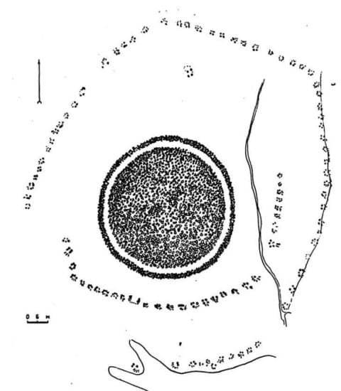
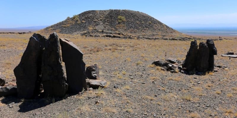
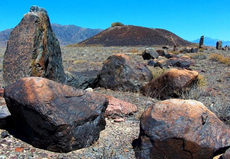
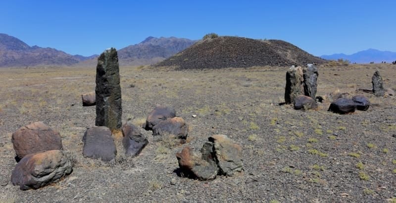
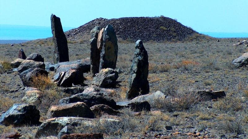
On the western and northwestern sides of the mound, the rampart stones were dismantled by local residents for building material. Another notable feature of the monument is the ring-shaped structures located near the mound, composed of large stone pillars (menhirs) dug into the mound's edges, and large boulders.
For convenience, we will refer to these structures as "enclosures." A total of 94 enclosures exist near the Great Mound. They are arranged in a spiral around the mound, with the beginning of the spiral (enclosure 1) located on the eastern side of the mound, 30 meters from the stone rampart, and the end terminating at enclosure 93, located to the south, 50 meters from the rampart.
In the northern part, the chain of fences runs 70 m, and in the west - 36 m from the rampart. The distance between the fences are 3 meters high on average, with a diameter of 2-3 meters. Fence 94 is located within a chain of fences located on the northern side of the mound.
Some of the vertical stone pillars of the fences are engraved with Kazakh clan tamgas, among which the so-called "koztanba" can be discerned. 250 meters northeast of the mound are seven more fences of a similar type, extending from southeast to northwest for 40 meters.
A large number of small shards of clay vessels, including occasional clay cauldron handles, were discovered near these isolated fences. In 1957, work was conducted to determine the purpose of the fences. Near the Great Mound, primarily on the southeast and south sides, 14 of the largest and most preserved fences were excavated.
With the exception of two of them, ash and soot stains (30 x 50 cm in size) were found at a shallow depth. In addition to ash stains, two enclosures contained small pieces of calcified bone, a small fragment of pottery, and a bead. It can be argued that enclosures generally had a cultic purpose, and in this case, they were undoubtedly associated with the cult of fire.
On the embankment of the Large Mound, there is a huge crater 32 meters in diameter and 7 meters deep, indicating predatory plunder.
Geographical coordinates of Besshatyr burial mound: N43°55'21 E78°12'38


Authority:
K. A. Akishev, G. A. Kushabayev.
"Ancient Culture of the Sakas and Wusuns of the Ili River Valley." Academy of Sciences of the Kazakh SSR. Ch. Ch. Valikhanov Institute of History, Archaeology, and Ethnography. Publishing house of the Academy of Sciences of the Kazakh SSR. Alma-Ata. 1963.
Alexander Petrov.
Photos by:
Alexander Petrov.