


![]()
You are here
History of island of Barsa-Kelmes.


Visiting valley Barsa-Kelmes.
“The islands in the Aral Sea - pancakes, poured onto a frying pan, flat to a gloss, spread out on the water - you can hardly see the shore, and there is no life on them. Neither birds, nor cereals, but the human spirit is only felt in the summer. The main island in the Aral Sea is Barca Kelmes. What it means is unknown, but the Kyrgyz say that "human death"»
Boris Lavrenev. "Forty-first".
"1848. August 6th. I starred on the 6th, went up to the island of Bars-Kelmes, and at night anchored in his sight.
8. Poured water from the wells, left the ensign. Akisheeva with 1 non-commissioned officer and 6 sailors for shooting the island.
10. The night was painful and the situation was so critical that I already recalled descriptions of shipwrecks and figured out what and how to build a raft. “I imagined the fate of those left on Bars-Kelmes: if I had wrecked, they were going to starve to death”
“Daytime notes of A.I. Butakov’s voyage along the Aral Sea in 1848 - 1849” Tashkent: Publishing House of the Academy of Sciences of the Uzbek SSR, 1959.
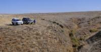
Trip from Kyzylorda to Barsa-Kelmes.
The history of the formation, settlement, and study of Bars-Kelmes is very interesting. There are many legends about him. Even his name is mysterious and mysterious - Barca-Kelmes means: "you will go - you will not return."
As the name implies, Barsa-Kel ¬ mes - a dangerous place, so named for a reason. There are various legends regarding the name of the island. Here is one of them. Long before the island appeared on the map of the Aral Sea, families from several Kazakh settlements located along the banks, during the period of internecine wars, decided to temporarily hide on a piece of land, far visible in the sea. In winter, on ice, people, along with their farm and livestock, safely reached the island.
But severe storms destroyed the ice bridge, and the fugitives could not return. They lived on winter, eating animal and bird meat, drinking snow water, and breaking dry saxaul for fuel. With the onset of the hot summer, the unforeseen happened - fresh water bodies formed by thawed snow in separate depressions and numerous depressions-takyrs dried up. People and cattle were left without water, and all died. No one returned to the mainland.
Since then they have called the blue hill on the smooth surface of the blue sea - Bars-Kelmes: "you will go, you will not return." And the hill was clearly visible in the morning and evening from the mainland, when the waves died down at sea and the air became transparent.
The island was still unexplored for a long time: no one knew the distance from it to the mainland, its shape and size, not to mention the relief, soil, flora and animals that inhabit this island. Incidentally, the name "Barca-Kelmes" is all hard-to-reach salt marshes located in the southeastern part of the Ustyurt desert. Currently, they are not comprehensively mastered by man.
For the first time, Bars-Kelmes was plotted on a geographical map in 1831 by the scientist A. Levshin. On the map of that time, in the southeastern part of the Aral Sea, numerous small islands were depicted under the name Barca-Katemes - their first graphic image.
Thus, such ominous names of the Aral Islands were known to the inhabitants of the Aral Sea region at least half a century ago. On the map of the Aral Sea that appeared in 1831, the island of Bars-Kelmes is allocated too much area and the outlines of its coastal lines are very distorted.
Apparently, the island was drawn approximately, like other small islands located in the southeastern part of the Aral Sea. No one has ventured to go there. Only in 1848 was a scientific expedition organized to study the islands of the Aral Sea, including Barca Kelmes.
It was led by Aleksey Ivanovich Buta¬kov, a charming, humane and democratically inclined person. He owes merit in revealing the secrets of Bars-Kelmes, and this required courage and talent. His biography is amazingly saturated. At sixteen years old he graduated from the Naval Cadet Corps, and after eight-ten years he had already circumnavigated the world. For the study of the Aral Sea in 1853, at the suggestion of the famous German scientist Alexander Humboldt, Butakov was elected an honorary member of the Berlin Geographic Society.
He worked on the Amu Darya and Syrdarya, specifying their outlines on the map. Butakov was later transferred to the Baltic Fleet, where he received the rank of rear admiral. Contemporaries speak of Aleksei Ivanovich “as a real type of naval officers that every country and every nation would be proud of.” Another remarkable person who visited the island of Kulans was the exiled poet Private Taras Shevchenko, whom Butakov took on a voyage along the Aral Sea to sketch the shores of the Aral Sea, violating the tsar’s order to forbid Shevchenko to write and draw.
This trip was a "gift" for the poet. The island keeps a memory of these people. There is a cape named after Butakov. He will be discussed later. Data on the Aral Sea, collected by Butakov’s expedition, interested scientists.
They gradually studied the geological structure of the numerous islands of this relatively small sea, the origin of their soils, the flora of animals, and the secrets of Bars-Kelmes were gradually revealed. It is now known that the islands on the Aral Sea were completely isolated from the land when the Aral basin was filled with the waters of two mighty rivers of Central Asia - the Amu Darya and Syr Darya. From the point of view of geology, this happened relatively recently - about fifty thousand years ago. And the islets themselves in the Aral basin were designated much earlier, since then twenty million years have passed. This is a considerable period.
As a result, the soil and vegetation growing on it, as well as the fauna of the islands, turned out to be of different ages. For example, the soil of the main massif of the island of Bars-Kelmes is gravelly-clayey, the vegetation cover consists of different species of wormwood and saltwort, its fauna is represented only by reptiles and small mammals, which are the indigenous inhabitants of the island, the rest migrated from the mainland.
A completely peculiar sandy landscape was formed here only after the final isolation of the island and only along the sea coast. The wide expanses of the Aral Sea served as an insurmountable barrier for many sandy species of animals (bogey jerboa, thin-toed gopher), and sand-plants (zhuzgun and others) somehow overcame them.
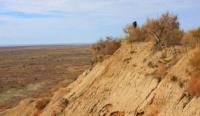
Barsa-Kelmes - the island is relatively small, its territory is limited: its length is 28 kilometers, its width in the western part is 11.5 and in the east it narrows to 2.5 kilometers, its area is about 180 square kilometers. The shape of the island is very diverse: the northern coast, bordered by sand dunes, is gentle, and the southern one abruptly breaks off, forming a chink (steep ledge) sixty to seventy meters high from the level of the Aral Sea.
And if you also take into account that northeast winds prevail, reaching tremendous strength, then the most convenient place for parking and unloading ships is the south-west coast at Cape Butakov on Zhamanmurun.
In the northern part there are vast sandy beaches, ridges of sand, lagoon lakes separated from the sea with very salted water. On steep banks - a pile of clay fragments in landslides and landslides. A characteristic feature of the natural conditions of Bars-Kelmem is the absence of permanent fresh water bodies.
With the problem of drinking water, the settlement of the island is associated. On the island - the only well with fresh water and so far indispensable. Who discovered it is unknown, but this person deserves deep gratitude. It is not yet clear where fresh water comes from in this old well, which is surrounded on all sides by salty, marine.
If it penetrates, filtering through sand, then why is it not in other parts of the dunes? If there are underground sources, then at what depth are they located and how are they located in the earth? Currently, the island has preserved the remains of drilling rig constructions on a clay plain, where wells were drilled to a depth of seventy-five meters, but there was no fresh water there either.
Another source of drinking water on the island is sea ice. It is very much appreciated here and is used only for drinking and cooking. Water from sea ice is almost fresh if the ice is harvested after it lays in stacks for a long time. Under the action of its own gravity, the ice is compacted, salt, which was contained in fresh sea ice, is removed from it.
Absolutely fresh water, even temporarily replacing distilled water, is snowy, but to harvest it for the summer is both unprofitable and impossible. In the years abundant in rains, the inhabitants of the island quite often took ice from the nearest temporary freshwater reservoir, filled with autumn showers so much that in winter the ice thickness in them reached half a meter and, in addition, an unfrozen layer of water remained almost below one meter deep.
Water is handled carefully on the island. The ice is now harvested in large quantities and stored in underground glaciers. With its economical consumption, fresh water is enough for the whole summer. Even before the arrival of the first explorers, there were already settlements on the island. A. Butakov reported that, before visiting the island with his expedition, Kazakhs lived for six years on them, who had a lot of livestock. But in the winter of 1847 - 1848, they went to the mainland.
Remains of their housing, almost flattened with land There is some information about the inhabitants of the island in pre-revolutionary times. For example, in the spring of 1914, part of Kazakh families from the nearest Kaskakulan island moved with their cattle to Barsa-Kelmes. According to the stories of local residents, before the October Revolution of 1917 a merchant and fishery man from the Ural Cossacks was in charge of the island, his name is unknown to anyone, and he was simply called Petka.
He himself lived on the mainland, on the island he was only a collision. Here, several Kazakh families worked for him. They built a dam on one of the beams of the northern part of the island and called this summer the drying reservoir “Petinkul”. This name has been preserved to this day.
The fisheryman had his own ship, for which a marina was built by the same Kazakh families, its traces were also preserved in the sands and on the plateau, two kilometers north-west of the Central estate of the current reserve. They don’t use it now.
Only after the victory of Soviet power did a detailed study of the island begin. Its unique flora and fauna are protected by law, carefully studied. In 1929, on the island, the hunting union of Soyuzpushnina was organized, which was engaged in breeding and fishing for gopher-sandstone. At the same time, some valuable commercial bird species (gray partridge, Syrdarya pheasant) and mammals - gazelles and saigas, rare at that time on the mainland, were imported here for the purpose of acclimatization.
Over the ten-year period of the existence of the hunting farm of Soyuzpushnina (1929 - 1939), there are houses on the Central Estate and on two cordons, dugouts in various areas, intended for housing for the period of hunting ground squirrels.
Temporary ponds-boogets are created, where melt and rainwater accumulate, as not only people needed fresh water, but also imported sharp antelopes and livestock. These reservoirs are called temporary because in dry summers they dry out and animals are forced to drink bitter-salty sea water.
Finally, in the sands of the northern part of the island after a long search, the inhabitants of the island find a place where fresh water lurked shallow from the surface. It was then that the only well was built. The road from this well crosses the tract Karagansai.
It is located four kilometers from the Central Estate of the reserve and is a beam covered with thickets of low caragana with fragrant golden yellow flowers. This is the most habitable place in the economy of the reserve, everyone knows it, young and old, livestock are constantly grazing there.
At the opposite end of the island, from the sea, the gates of Kebirsai open. Kebirsay is a deep hollow of the peripheral part of the plateau with red-wooded beams and sometimes green, swollen on the surface of the soil, devoid of any vegetation. This is a one-piece almost lifeless corner of the desert, wonderful in its own way. A narrow strip of vegetation runs only along the bottom of deep beams. On the kebir slopes, saiga and gazelles trails are visible.
They lead to water. Segizzay is located southwest of Kebirsay, which in Kazakh means eight beams. They cut a plate in the direction of the sea. This is a green, flowering and very lively place in the reserve. Grains and forbs, single dzhigil bushes grow luxuriantly in the beams, and in the elevated areas from afar stands out the patriarch of the clay desert - the black saxaul. Wild hoofed animals and livestock are constantly grazing here.
On the way from Segizsay to the Central Estate there is the Aliyev Buget, which detains melt and rain water flowing from the plateau. This artificial pond bears the name of an old-timer of the island, who knew its nature perfectly. Watering paths stretch to the tract Dzhingildykul - a small, round-shaped takyr, overgrown with jingil around. It is filled with fresh water in spring and autumn and is remarkable as an area of mass lambing of saigas in years abundant in spring rains.
A little to the north, in the beams of the elevated plateau, there is another source of water - the Dzhedybaevsky buget, named after the old-timer of the island, and a garden buget in four kilometers west of the Central Estate. Here, tamarisk flowers are fragrant all summer.
This is a kind of oasis in the desert, where fresh water lasts longer and wild ungulates gather more often. In general, the names on Bars-Kelmes were given in honor of one of the inhabitants of the island. In the forties, that is, almost in our time, a meteorologist lived and worked in the reserve, after whom one of the officers to the west of the Central Estate, Akhmetov Yar, was named.
On the elevated plateau there is another sign noticeable from afar - "Nikolaev dugout", from which only a tubercle has survived. This place is named in memory of a hunter who died at the front during the Great Patriotic War, - N. Rozhdestvensky.
Often the name is associated with an event. For example, somewhat east of Karagansay, in the lowland, but beyond the limits of the dunes, is the Saigach yard. Old-timers said that the first batch of saigas brought from the mainland was released here.
From here they settled across the island. Now saiga brought from the mainland. From here they settled across the island. Now saigas are kept in large herds here, in the heat of the day sitting down to rest on puffy soils, as if on soft carpets, taking advantage of the proximity of the sea for watering.
However, in their favorite “yard”, saigas have never lambered for the entire time they were on the island, since they are crowded here, their number is significant now. To the north there is a steep climb to an elevated plateau.
Its prominent part, facing the west, is called Chaikagora, where before it seemed that loud silver gulls nested, then settled small islands on salt lakes and sands of the sea coast. At the very edge of the island, the eastern skid clearly stands out - a narrow and pointed strip of sandbank deep in the sea, which is also found on the opposite western part of the island.
The local population knows them well as the nesting area of gulls, and captains of ships also know and remember their whole lives, especially if they only had to sit aground and wait for the tide, although it is weakly expressed in the Aral Sea. Sailors bypass this area very carefully, far from the coast.
On the spit there used to be a lighthouse glowing at night and in dense fog, it towered above the very cliff south of the eastern spit. Now the lighthouse has been demolished, a meteorological station has been built there, and the area, by habit, is now called the "Lighthouse", although there is no trace left of it, but such is the strength of the habit.
Near the eastern spit is located, stretched from north to south, Small Salt Lake - a nesting place for common terns. The water in it has now dried up, and the bottom has turned into a white puffy salt marsh, from which dust rises in pillars in windy weather.
In the northwest there is also the Big Salt Lake, where various waterfowl nest. In the midst of flight, when the lake dries up, its bottom serves as a rookery for antelopes. If you go south from here, you will come to Zhamanmurun cordon, which means "bad nose."
And it’s not in vain that it is so called: here the descent to the sea is very steep.
Authority:
M.I. Ismagilov. "Island of the Kulans." Series "Man and Nature." Kaynar Publishing House, Alma-Ata, 1973.
Photos by
Alexander Petrov.