


![]()
You are here
Inder-Emba karst.
Study tours and excursions in Kazakhstan.
"Nature is easiest to subjugate by obeying it."
Francis Bacon.
Tourism in Atyrau region.
Inder-Emba karst district unites the following karst areas: the surroundings of Inder and Chelkar lakes (Kazakh. Shalkar). The vicinity of Inder Lake is located in the Inderbor region of the Atyrau region of the Republic of Kazakhstan on the left bank of the Ural River and is a salt-domed elevation in the form of a plateau-like elevation elevated by 20 - 25 meters above the surrounding steppe and complicated by gypsum hills and karst funnels.
As well as the area around Lake Baskunchak, the Inder uplift has long attracted the attention of many domestic researchers, such as P.S. Pallas, P.A. Pravoslavlev et al. However, the most comprehensive studies of the geology of this region began only in the mid 30s in connection with the discovery and exploration of the borate deposit.
In 1935 - 1936, the Inder Borat Expedition of TsNIGRI worked here. Karst processes and phenomena were studied by Z.V. Yatskevich, G.R. Aleschenko, S.S. Korobov, I.K. Polenov, E.I. Nurmambetov, A.V. Sotnikov, Yu.V. Archdeacon and others.
Sulfate karst developed on the northern and northeastern shores of Lake Inder, due to the emergence of ancient Late Paleozoic sedimentary rocks represented by the thickness of eluvial gypsum (elP2-Q) on the day surface.
Karst rocks are raised to the surface due to salt tectogenesis and make up the upper part of the caprock of the salt-dome massif. The surface of the plateau is actively karst. The karst relief is represented by funnels of various types, ponors, ravines, hollows, valley-shaped depressions and caves.
Among the various forms of karst relief in the vicinity of Lake Inder, the most interesting are caves. They are common in the central and eastern parts of the Inder Rise. Interestingly, regarding the number of caves, the opinions of researchers differ.
Some argue that they are small and insignificant, while others note a large number of them. Their descriptions contradict. If we take into account that the researchers cite a very cursory description of the caves in general terms with approximate parameters, we can conclude that the area is poorly speleological and the role of the speleological method is underestimated in karstological studies.
During the expeditionary work carried out by members of the speleology and karstology section of the Astrakhan branch of the Russian Geographical Society, while studying the karst relief formed on the Inder uplift, special attention was paid to the search and inspection of karst caves.
We discovered several caves, among which two caves were already briefly mentioned in publications of various researchers. These are karst-erosion caves of Utelis-Kstau and One-Eyed Well. Utelis-Kstau cave (from Kazakh. "Otemis kystau" - "Otemis wintering") is the most famous and accessible cave cavity.
Her brief description and diagram is given in his article by Z.V. Yatskevich. The cave is horizontal, located in the eastern part of the Inder Rise. Utelis-Kstau belongs to the corrosion-erosion type and is located near the day surface.
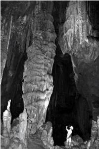
It was developed in gypsum deposits of the salt dome cap (elP2-Q). The cave is a checkpoint, has two entrances, different in size and morphology. The main entrance faces north and has dimensions: height - 3.7 m, width - 3 m.
The cave is a large well-lit underground hall (24 square meters in area, 45 cubic meters in volume and 1.8 to 2 meters high) ), which is associated with a system of cracks and channels of various sizes and morphology.
The floor deposits in the cave entrance hall are represented by thin, dusty sandy loam covering the gypsum coarse material. The general ecological condition of the cave is satisfactory. The microclimate of the cave, due to the large size of the inlet, is highly dependent on surface weather conditions.
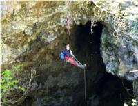
One-Eyed Well Cave is a karst well that opens at the bottom into a small cave cavity. The neck of a well measures 10 meters x 4 meters, in the middle and lower part 6 - 5 meters x 1 meter. The depth to the bottom of the cave is 29 meters.
At the very bottom of the well, it passes into the cave chamber, up to 6 m high, 11 m wide and 13 m long. In the middle of this chamber, under the well, there is a cone of landslide deposits up to 4 - 5 m high, covering the entire bottom area of the cave cavity.
The cave is a "cold sack" and has snow and ice deposits.
Authority:
http://rosstroy.info "Caves of the Northern Caspian" I. V. Golovachev Astrakhan State University; Astrakhan branch of the Russian Geographical Society 414052, Astrakhan, ul. Artelnaya, 16. E-mail: bask_speleo@mail.ru
Photos
Alexander Petrov.