


![]()
You are here
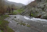
Island mountains of Kyzylkum desert.
Mountains in north of Uzbekistan.
"At the foot of the great mountains
The grass stalks sway a little.
I look up into the blue
Clouds rush into space
Spread white manes.
... I'm walking along a mountain path,
At the peaks, meeting the dawn.
Horus I do not know the equal of Arpa,
There are no more free pastures for us.
Like a flock of white geese
That they dispersed along the pasture,
Mountain stones covered the slope,
And over the world in the beauty of its Mountain,
mountains all around"
Kalyk Akiev. Translated by T. Streshneva). "The day is saying goodbye...".
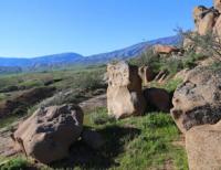
Mountains in Navoi region.
The island mountains of the Kyzylkum desert are located in the north of Uzbekistan, in the eastern part of the Navoi region, in the eastern and northern parts of Karakalpakstan. The Hercynian folded structures of the base of the Turan plate protrude to the surface in the form of low island mountains characteristic of the Kyzylkum desert, up to 470 - 920 m. a. s. l.
These are the remnant ridges: Bukantau with the highest point Mount Irlir 764 m. a. s. l., Zhetimtau with the highest mountain of the same name 565.5 m. a. s. l., Tamdytau with the nameless highest peak 678.5 m. a. s. l., Kuldzhuktau with the highest mountain Aktasty with a height of 713.7 m. a. s. l. and many others, in the west - the Sultan-Uvais ridge with the highest mark Mount Ashchytau with a height of 478.7 m. a. s. l.
The mountains are the remnants of the Hercynian folded formations located on the continuation of the northern chains of the Gissar-Alai system (the Turkestan ridge and the Nuratau ridge) and uplifted by the latest tectonic movements.
The ridges are composed of highly dislocated and metamorphosed Paleozoic shales, limestones, granites and others.
On the tops and ridges of many remnants, leveling surfaces are developed, used for rainfed crops. The desert slopes of the remnant mountains are dissected by short gorges, at the foot there are trails of rubble-sand accumulations. Often they serve as receptacles for fresh groundwater, which in some places are fed by springs that supply mining villages with water.
In the remnant mountains there are various mineral resources (marble, graphite, turquoise, asbestos, coal, etc.), mines are operating. Not so long ago, the Muruntau gold deposit was discovered, where the city of Zarafshan (“gold-bearing” - in Uzbek) has already grown.
Geographical coordinates of island mountains of Kyzylkum desert: N42°02'20 E64°11'27
Geographic coordinates of Bukantau mountains: N42°31'25 E63°43'04
Geographic coordinates of Zhetimtau mountains: N42°04'21 E64°51'34
Geographic coordinates of Tamdytau mountains: N41°28'51 E64°07'28
Geographic coordinates of Kuldzhiktau mountains: N40°49'02 E63°44'19
Geographic coordinates of Sultanuvais Ridge: N42°02'46 E60°32'46
Authority:
Gvozdetsky N.A., Golubchikov Yu.N. "Mountains", series "Nature of the World". Moscow, Thought, 1987.
Photos by:
Alexander Petrov.