


![]()
You are here
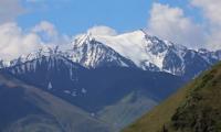
Kairakty gorge.
Traveling in “Kolsai kolderi” park.
“I don’t know where to meet
We'll have to go with you.
The globe is spinning, spinning
Like a blue ball
And cities and countries flash by,
Parallels and meridians
But nowhere are there such punctures,
On which we roam the world. "
"Globe". 1947. Poet M. Lvovsky wrote his poems to the already existing composition by Mikhail Svetlov.
Weekend tours in “Kolsai kolderi” park.
The Kairakty gorge is located between the Korumdyk gorge in the east and the Kugantor gorge in the west, on the northern slope of the Kungey Alatau ridge, on the territory of the “Kolsai kolderi” natural park in the Kegen district of the Almaty region.
The sources of the Kairakty River begin at an altitude of 3731.8 meters above sea level, from a complex glacier located on the northern ridge of the Kungey Alatau ridge. The Kairakty tributary, in turn, consists of two left small tributaries and 4 right unnamed tributaries.
At an altitude of 3162 meters above sea level, the channel of the Kairakty river is formed, which the river receives from two tributaries of the Eastern and Western. The western tributary originates from two glaciers separated by a small meridional bridge in the lingual part there is one moraine lake.
The lakes are located at an altitude of 3618 meters above sea level. Glaciers start from the main ridge of the Kungey Alatau ridge at an altitude of 4104 meters above sea level and flow northward to the height of the moraine lake located in its northern lingual part.
The eastern tributary originates from a glacier located in the upper ridge part at an altitude of 4021 meters above sea level and flows northward for 2 kilometers. The tongue of the glacier ends at a moraine lake at an altitude of 3688 meters above sea level, and there are also three moraine lakes.
The length of the gorge is 9.5 kilometers. In the watershed of the ridge, which separates the Kayrykty and Zhamanbulak gorges, the highest point of the summit is located at an altitude of 4457.5 meters above sea level.
Geographic coordinates of the Kairakty gorge: N42 ° 59'45.09 "E77 ° 29'39.32"
Authors:
Alexander Petrov.
Vukolov V. N. “Across the Northern Tien Shan. Mountain tourist routes along the Trans-Ili Alatau and Kungey Alatau. Speaker: Master of Sports of the USSR A.F. Kharchenko. M . Profizdat, 1991.208 p.
Photos by
Alexander Petrov.