


![]()
You are here
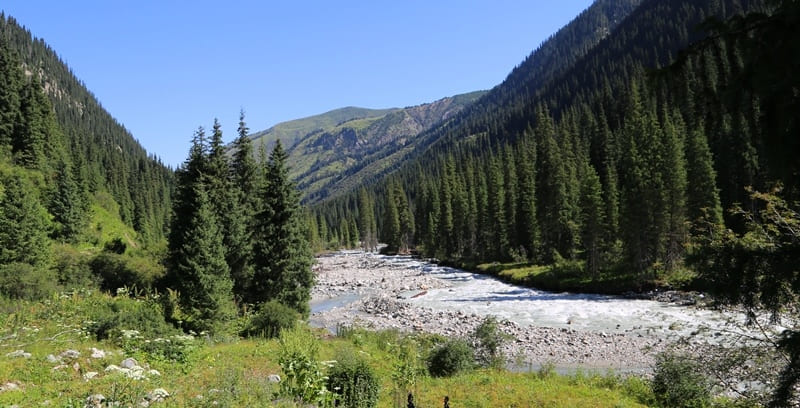
Karakol River in Terskey Ala-Too Mountains.


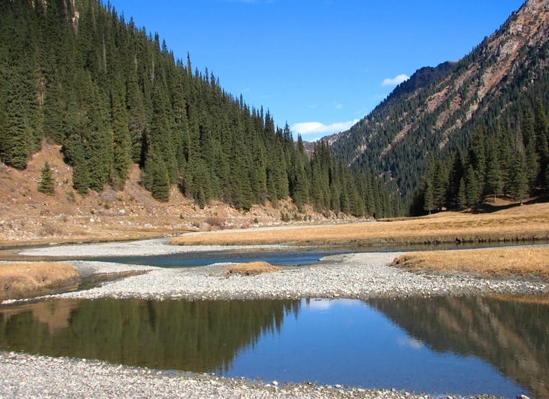
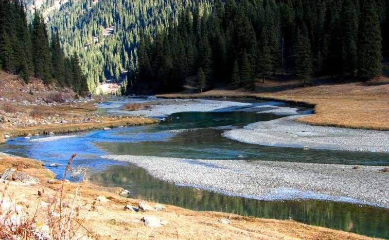
Rivers in Terskey Ala-Too mountains.
"The road descends steeply, spiraling downwards, and would be completely impassable for camels if it were rocky, but fortunately, it is completely smooth and covered with fine gravel. In two places, over several fathoms, there are rocks, thanks to which the caravan abandoned two camels in this pass. We spent the night on the southern slope, by the Karakol River. The Karakol River flows from east to west, then breaks through the Chakhrhorum Mountains and flows into the Naryn. The Karakol Valley is, of course, the lowest point in Syrt."
"Kashgar Diary. Summit of Zaukin Pass." Chokan Valikhanov. 1858.
"The banks of both the bay and the Karakolka River have partly slid toward the water, settling in ledges, while others have completely submerged."
Geologist I.V. Mushketov. 1889.
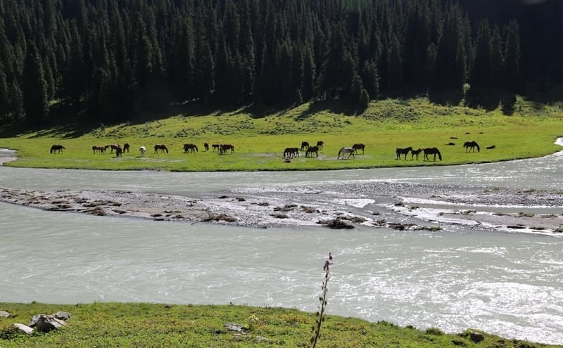
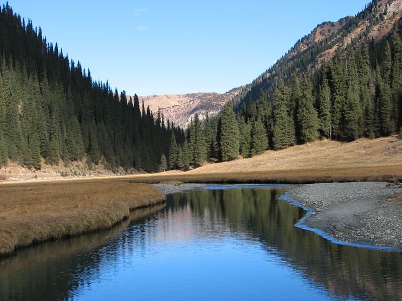
Trip to Karakol River from Cholpon-Ata.
The main channel of the Karakol River forms at an altitude of 2,598 meters above sea level from the confluence of three rivers: the right tributary Keltor, the middle tributary Uyuctor, and the left tributary Telety. The river's source is located in a high-mountain glacier zone within a large glaciation zone.
From the confluence of these three rivers to its mouth in the southern part of Przhevalskoye Bay of Lake Issyk-Kul, the Karakol extends for 40 kilometers.
The river basin contains the following lakes:
- Lake Ala-Kel, located at an altitude of 3,532 meters above sea level, on the western slope of the Karakol Gorge;
- a moraine lake located in a cirque between Atjailau Peak, 3,689.3 meters above sea level, and the Aitor River valley. The lake is the source of a 3.5-kilometer-long unnamed river, which is the left tributary of the Karakol River.
The town of Karakol (formerly Przhevalsk), the village of Chelpek, Böryu-Bash, Burma-Su, and others are located on the Karakol River.
Geographical position of Karakol River.
Karakol River flows through eponymous gorge, located in eastern part of Issyk-Kul Basin, draining northern slope of Terskey Ala-Too Range. River flows directly into Lake Issyk-Kul, forming an alluvial fan on eastern outskirts of town of Karakol. Located in Aksu district in eastern Issyk-Kul region.
Karakol River basin lies within:
The upper mountain-glacial zone (sources),
the subalpine and forest zone (middle part of the valley),
the piedmont-dry steppe zone (lower reaches).
Geological and morphostructural structure of Karakol River basin:
Karakol basin is confined to the fault zone of the northern edge of the Issyk-Kul depression.
Basement rocks are dominated by:
- crystalline gneisses and schists of Paleozoic age,
- granitoid intrusions,
- metamorphic zones, and folded dislocations. The river valley is formed by glacial exaration, with distinct features:
- trough valleys (U-shaped profile),
- cirques in the upper reaches,
- moraine ridges of various origins (terminal, lateral, and central),
- rock screes and kurums in zones of crystalline rock destruction.
In the lower part of the valley, alluvial-deluvial deposits and fan-shaped outflow processes are observed at the mouth.
Hydological characteristics of Karakol River.
The river is fed by glaciers and snow with a pronounced seasonality. The main source is meltwater from glaciers and snow. Floods occur from late April to September. The river's drainage basin covers 394 square kilometers. The average long-term water discharge is 6.6 cubic meters per second.
The river's flow velocity in the Karakol River does not exceed 1.5 meters per second. In its lower reaches, the river crosses the city of Karakol from south to north. It flows into Przhevalsky Bay at the eastern end of Lake Issyk-Kul at an altitude of 1,608 meters above sea level.
The largest tributary of the Karakol River is the Kashka-Su River. The average long-term water discharge is 6.60 cubic meters per second.
Maximum flow: July - August
Minimum flow: January - March
Average annual water temperature: +3...+6 °C (lower upstream).
River runoff fluctuates daily in summer (decreases overnight and increases during the day), which is due to the intense melting of firn and glacial masses.
The riverbed is predominantly rocky, with occasional widening pools. Rapids and steps associated with moraine and structural rapids are present.
Glacier system in upper reaches of Karakol River.
Several small glaciers, related to the modern remnant glaciers of the Terskey Ala-Too, are located in the Karakol basin.
Glacier types include:
Hanging, cirque, and cirque glaciers,
small tongue glaciers descending into cirque widenings of the valley.
Average glacier thickness is 15-60 meters, with a consistently positive rate of degradation (retreat).
Vegetation and altitudinal zonation of Karakol River Valley.
Altitudinal Zone Altitudes Dominant Formations
Nival-glacial 3,500 - 4,000 m: bare rock outcrops, glaciers, firn fields
Alpine 3,000 - 3,400 m: sparse mountain meadows, rhododendron clumps, rocky substrates
Subalpine 2,500 - 2,900 m: shrub formations, tall grasses
Mountain forest 2,000 - 2,500 m: Tien Shan spruce (Picea schrenkiana)
Foothill zone below 1,900 m: forb-grass steppes, shrubs
Karakol Valley is a typical example of the altitudinal zonation of the northern slope of the Terskey Ala-Too.
Economic and scientific significance of Karakol River Valley.
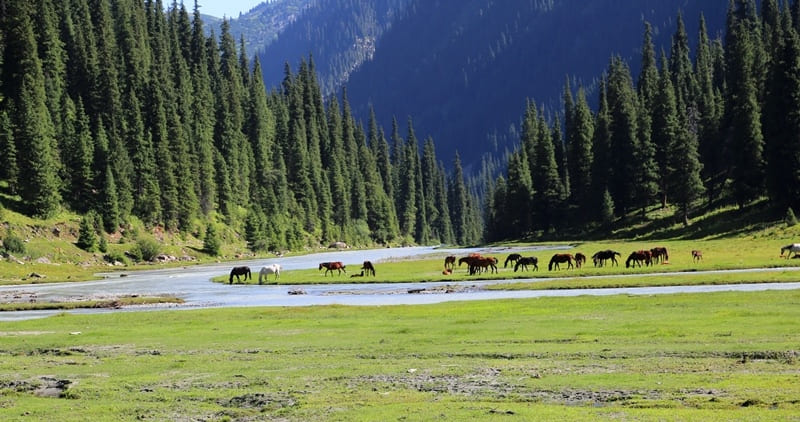
The valley is considered a benchmark for studying the dynamics of modern glaciers in the northern Tien-Shan. The Karakol Gorge has long served as one of the routes to high-mountain pastures, or dzhailau. Steppe tribes would ascend here in the summer with their herds, setting up yurts near springs and streams.
It is used as a base for glaciological and geobotanical research routes.
The lower part of the valley is an active grazing area (summer flocks).
The Karakol Gorge is a major tourist center: a ski resort is located in the lower part of the gorge, a tourist camp is located at the mouth of the Ayutor River, and ascents to Karakol Peak, Oguy Peak, and the Ala-Kul Plateau begin here.
The valley serves as the starting point for the classic trekking route "Karakol - Ala-Kel - Altyn-Arashan."
Here are pastures, sheepfolds, and summer pastures where yaks and horses have long been grazed. Historically, the gorge was used as a route to the passes on the southern side of the ridge, including the crossings into the Irtash, Uchkel, Sarychat, Kuylyu, and Sarydzhaz river valleys.
During the 20th and 21st centuries, the area was used in the scientific works of geographers Mushketov, Korzhenevsky, Palgov, and others.
Legend of Karakol River.
They say that once upon a time, a young hunter named Karakol lived deep in this valley. He was known for his courage and pure heart. One day, a severe heat wave descended on the mountains. The rivers dried up, and the herds began to die. Then Karakol climbed high into the mountains and appealed to the spirits of the glaciers to return the life-giving water.
Sveta did not see what happened, but a stream suddenly burst forth from the summit - pure and clear as a tear. They say that Karakol's soul became a river, forever watering the land and its people. Since then, the river's water has been considered kind and life-giving.
Before setting out on a journey, travelers would fill their skins with it and drink it in small sips - to lighten their hearts.
Geographic coordinates of Karakol River: N42 ° 25'19 E78 ° 26'06
Tributaries of Karakol River.
River Keltor.
Keltor River, 14 kilometers long, is the right (eastern) tributary of the Karakol River. The river in the upper reaches is formed from two tributaries. The right tributary originates from the northwestern slopes of a small spur, in which the Ukraintsev pass is located.
The left tributary (western) originates from the Dzhigit glacier flowing down from the northern slope of the Dzhigit peak 5020 meters above sea level and from the eastern slope of the Ontor pass 3900 meters above sea level. The Ontor pass is located in a minor, northern spur of the Terskey Ala-Too ridge, on the north side of the Dzhigit peak, the valleys of the Ontor (Uyuktor) rivers with the Ontor glacier and Keltor with the Dzhigit glacier (both are the sources of the Karakol river) will separate.
The pass is located on the northern wall of the Dzhigit peak. 900 meters before the mouth, the Keltor on the right receives an unnamed 4.2 km tributary. The sources of the tributary begin from the western slope of the summit, 4003 meters above sea level. The mouth of the river is located at an altitude of 2598 meters above sea level.
Geographic coordinates of Keltor River: N42 ° 15'38 E78 ° 32'08
Uyuktor River (Ontor).
he Uyuktor (Ontor) River with a length of 13.4 kilometers is the middle tributary of the Karakol River. The river flows from the Western Karakol glacier with a length of 3.8 kilometers, flowing down from the northern slope of the Karakol peak at an altitude of 5216 meters above sea level.
There is an almost vertical wall between the Karakolsky and Elephant peaks, along which the East Karakol glacier slides 5 kilometers long. This glacier also replenishes the Uyuktor River with waters. From the western slope of the Ontor pass, the Ontor glacier descends, 1.5 kilometers long, which connects with the East Karakol glacier.
In the upper reaches of the river there is the Elephant Peak, 4726 meters high above sea level. The mouth of the Uyuktor (Ontor) river is located at an altitude of 2598 meters above sea level.
Geographic coordinates of Uyuktor River: N42 ° 13'47 E78 ° 29'04
Telety river.
Telety River, 7 kilometers long, is the (left) western tributary of the Karakol River. The river is located to the west of the dividing, meridional ridge with a length of 15 kilometers, which departs from the main ridge of Terskey Ala-Too just to the west of the Karakol peak.
The river replenishes water from three small glaciers located on the northern slope of the Terskey Ala-Too ridge and partly from the northeastern slope of the Telety pass, 3801 meters above sea level. The forest zone in the valley of the Telety river rises to 2808 meters above sea level. The mouth of the Telety River is located at an altitude of 2598 meters above sea level.
Geographic coordinates of Telety river: N42 ° 17'01 E78 ° 27'52
Rights tributaries of Karakol River.
Ala-Kel river.
3 kilometers after the beginning of the Karakol River, the tributary Ala-Kel, 4.5 kilometers long, flows into the right. The river originates from the Ala-Kel lake located at an altitude of 3532 meters above sea level on the western slope of the Karakol gorge.
The river flows out through a natural dam blocking the lake in the northwestern part. The difference in height on the river is 1057 meters by 4.5 kilometers. The river is very rough and full of water. In some hard-to-reach places, the river forms waterfalls. The mouth of the river is located at an altitude of 2475 meters above sea level
Geographic coordinates of Ala-Kel River: N42 ° 19'33 E78 ° 30'02
Nameless stream, right tributary of Karakol.
4.6 kilometers after the confluence of the Ala-Kel River, an unnamed stream 3.5 kilometers long flows into the right. The stream originates from the tongue of a glacier 2.3 kilometers long, located on the western slope of the Karakol gorge in the Terimtor mountain spur.
The glacier descends from the Terimtor spur into the valley of the Karakol River, from a small sub-latitudinal ridge 3900 meters above sea level. In the eastern part of the glacier, there is the Przewalski Peak 4271.9 meters above sea level.
In the moraine of the lower part of the glacier, there are two small flowing lakes. The mouth of an unnamed stream is located at an altitude of 2303 meters above sea level.
Geographic coordinates of unnamed stream: N42 ° 21'40 E78 ° 29'25
Kashkasu river.
hrough 7.8 kilometers after the confluence of the unnamed stream on the right, the Kashkasu tributary with a length of 10.2 kilometers flows into Karakol. The river starts from the Kashkasu glacier with a length of 3.9 kilometers located on the northern slope of the Terimtor spur.
The sources of the Kashkasu glacier are located in the circus, in the eastern part of which is the Przewalski Peak. In the western part of the Kashkasu River there is a mountainous, remnant massif Aidyanish with a dominant height of 3228 meters above sea level.
Remnant rocks in the massif reach a height of 33 to 56 meters. In the middle course, the river flows from the eastern side of the Karakol ski base. The mouth of the Kashkasu River is located at an altitude of 1996 meters above sea level.
Geographic coordinates of Kashkasu River: N42 ° 24'01 E78 ° 28'54
In the lower part, not far from Lake Issyk-Kul, the Karakol has a drying right tributary, which is filled with rainfall, and in the spring when the snow melts.
Left tributaries of Karakol River.
Aytor River (Ayutor).
2.6 kilometers after the beginning of the Karakol River, the Aitor River, 4 kilometers long, flows into the left. The mouth of the Ayutor River is located at an altitude of 2536 meters above sea level, just above the right tributary of the Ala-Kel River.
The sources of the river originate from 5 glaciers located on the northern and northwestern slopes of the watershed ridge with the Telety river. The longest of them is the Aitor glacier, 2.5 kilometers. The origins of the glacier are located on the northern slope of Gastello Peak 4350 meters above sea level.
Aytor Peak is located on the eastern ridge of the circus. From Peak Gastello to the northeast in the ridge there are peaks: TRP (Ready for Labor and Defense), GERO, Students, Heroes of Krasnodon, Meneleevets.
Geographic coordinates of Aytor (Ayutor) river: N42 ° 18'27 E78 ° 27'04
Left unnamed tributary of Karakol River.
1.5 kilometers after the confluence of the right tributary of the Ala-Kel, a small unnamed tributary 3.5 kilometers long flows into the left. The sources of the river begin from a moraine lake located in the circus, which is the watershed of the Irdyk and Ayutor rivers.
The mouth of the unnamed tributary is located at an altitude of 2389 meters above sea level.
Geographic coordinates of unnamed tributary: N42 ° 20'08 E78 ° 27'07
Zyndanbulak stream.
5.7 kilometers after the confluence of the left unnamed tributary, the spring tributary Zyndanbulak with a length of 3.8 kilometers flows into Karakol on the left. The sources of the stream are in the Atjailau tract. In its upper reaches, the Atjailau peak is located with a height of 3689.3 meters above sea level. The mouth of the Zyndanbulak stream is located at an altitude of 2205 meters above sea level.
Geographic coordinates of Zyndanbulak stream: N42 ° 22'23 E78 ° 27'16
Stream Karchkiya.
3.8 kilometers after the confluence of the Zyndanbulak brook, the Karchkiya tributary with a length of 7.7 kilometers flows on the left. The spring sources of the river are located in the Atjailau tract, in its upper reaches the Atjailau peak is located with a height of 3689.3 meters above sea level.
The mouth of the Karchkiya stream is located at an altitude of 2054 meters above sea level.
Geographic coordinates of Karchkia River: N42 ° 23'23 E78 ° 25'18
Authority and photos by:
Alexander Petrov.