


![]()
You are here
Terskey Ala-Too ridge.

Tours in Mount Terskey Ala-Too.
"We went along the Terskey valley {The northern shore of Issyk-Kul is called Kungey, facing the sun, since its slope is at midday, and the southern one is Terskey, turned away, i.e. away from the sun, since the slope is north. Accordingly, the ridge on the northern shore is Kungey-Ala-tau, and on the southern one is Terskey-Ala-tau.}, which is, in fact, not a valley, but a low ledge tapering to the west, between the southern shore of Issyk-Kul and the accompanying Terskey-Ala-tau ridge, the watershed between the tributaries of Issyk-Kul and the Naryn. Be that as it may, only the foothills of this ridge are visible from the road; it is too close; only through the valleys of the rivers flowing from it, passing by their exits, can one see in the background of the gorge deepening into the mountains, huge peaks, belted by a wide strip of dark-bluish spruce forests and crowned with eternal snows. The general view of the ridge opens only from the northern shore of the lake and, according to the eyewitness P. P. Semenov (Notes of the Geographical Society on General Geography, 1867, p. 213), amazes with its grandeur."
"Travel through Turkestan region and exploration of mountainous country of Tien-Shan." N. Severtsov. 1873.
Travel in mountains of Kyrgyzstan.
Terskey Ala-Too, ridge is located in south of Issyk-Kul basin, its eastern part belongs to Central Tien-Shan system, is located in Naryn and Issyk-Kul regions.
Length of the ridge from Semenov Peak in the Sary-Dzhaz Range to the northwestern part of the Son-Kol Lake basin is 375 kilometers.
There are three parts in Terskey Ala-Too:
Estern part adjoins the Sary-Dzhaz Range and is limited by the Tyuz-Ashuu Pass. Central part is between the Tyuz-Ashuu and Dzhuku Passes, with the following peaks: Karakol, 5216 meters above sea level, Dzhigit, 5170 meters above sea level, Jety-Oguz Wall, 5180 meters above sea level.
Western part is between the Dzhuku Pass and the Chu River Valley, with peaks up to 4763 meters above sea level.
Most significant spurs are in Terskey-Ala-Too Range.
The northern slope of Terskey Ala-Too is heavily dissected - about 20 significant, more than 50-kilometer spurs extend from it, one of which passes into the Kyungoy-Ala-Too ridge, as well as about 20 small spurs. 5 - 6 large spurs extend to the south, the rest, over 50, are low and short.
One of the southern spurs is a bridge connecting with the Keolyu ridge, the other - with the Jetim-Bel ridge. In the western part of Terskey Ala-Too, the southern spurs connect or pass into the Kara-Dzhorgo, Kara-Goman, Kara-Moinok, Uchemchek ridge, with a length of 50 - 100 kilometers.
The elevation changes on the northern slope are from 2000 to 4000 - 4500 meters above sea level, on the southern slope mainly from 3000 to 4000 - 4500 meters above sea level. The highest pass is on the shoulder of Karakol Peak - up to 4800 meters above sea level.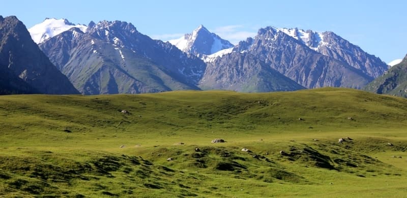
The easiest ways to cross the ridge are by road through the Tyuz-Ashuu and Barskoon passes.
Western Terskey spur, 125 kilometers long, is located at an altitude of 3200 to 4763 meters above sea level.
Central Terskey spur. The main ridge, 150 kilometers long, is located at an altitude of 3600 to 5216 meters above sea level.
Northern Spurs of Central Terskey spur, 25 - 50 kilometers long, is located at an altitude of 3200 to 4716 meters above sea level. The Southern Spurs of the Central Terskey spur, 15-20 kilometers long, is located at an altitude of 3,000 to
,843 meters above sea level.
Eastern Terskey spur, 100 kilometers long, is located at an altitude of 3,200 to 4,600 meters above sea level.
The snow line is on the northern slopes at an altitude of 3,700 - 3,900 meters above sea level. On the southern slope at an altitude of 2,000 - 2,500 meters above sea level there are forests of Tien Shan spruce, higher up there are subalpine and alpine meadows, which give way to nival landscapes.
The southern slopes are covered with alpine tundra vegetation, above 3,000 meters above sea level there is a high-mountain cold desert, in the river valleys there are alpine meadows.
Geological history of Terskey Ala-Too ridge.
In the Paleozoic and Mesozoic periods, the territory where the Issyk-Kul Basin and the ridges surrounding it are now located was covered for a long time by the inland Tethys Sea, which created a thick layer of sedimentary rocks. Mountain-building processes took place both a long time ago - during the Paleozoic period, and comparatively recently - in the Tertiary and Quaternary periods.
From the intrusion of magma into the thickness of the earth's crust in the Paleozoic period, massive granites and diorites of Terskey and Kungey have been preserved, the cores of these ridges are composed of ancient (Precambrian and Lower Paleozoic) deeply metamorphosed (modified) rocks: gneisses, marbles, quartzites and crystalline schists.
Features of orography of Terskey-Ala-Too ridge.
The Terskey-Ala-Too ridge is characterized by a deeply dissected alpine type of relief with modern glaciation and relative altitude amplitudes of more than 1000 meters above sea level. The ridge is asymmetrical: it has a short gentle southern slope and a long northern slope.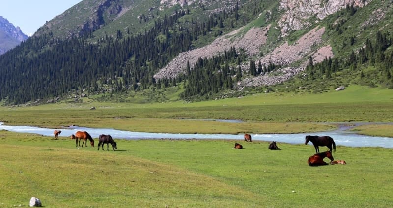
Dissected by deeply cut gorges the territory where the Issyk-Kul basin and the ridges surrounding it are now located was covered for a long time by the inland Tethys Sea, which created a thick layer of sedimentary rocks. Mountain-building processes took place both a long time ago - during the Paleozoic era, and comparatively recently - in the Tertiary and Quaternary periods.
From the intrusion of magma into the thickness of the earth's crust in the Paleozoic era, massive granites and diorites of Terskey and Kungey have been preserved, the cores of these ridges are composed of ancient (Precambrian and Lower Paleozoic) deeply metamorphosed (modified) rocks: gneisses, marbles, quartzites and crystalline schists.
Features of orography of Terskey-Ala-Too ridge.
The Terskey-Ala-Too ridge is characterized by a deeply dissected alpine type of relief with modern glaciation and relative altitude amplitudes of more than 1000 meters above sea level. The ridge is asymmetrical: it has a short gentle southern slope and a long northern slope.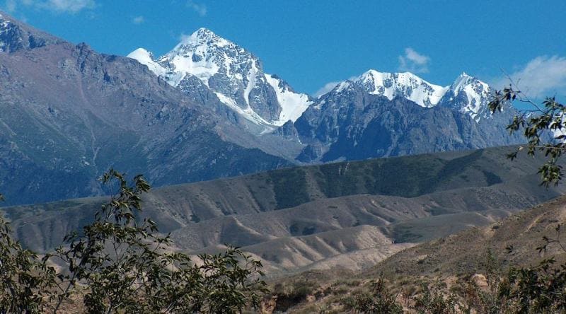
Dissected by deeply cut gorges, the northern slope descends in giant steps to Issyk-Kul. The very crest of the ridge is slightly dissected, carries flat surfaces inclined to the south, in places imperceptibly turning into the southern slope. The highest central part of the Terskey Ala-Too ridge is between the Barskoon and Turgen-Aksu gorges, the highest point is Karakol peak 5280 meters above sea level in the upper reaches of the Ontor River, the left source of Karakol.
The following passes are located here (from west to east): Barskaun, Dzhuuk, Kashkasu, Dzhukuhchak, Ashutor, Karakol, Festivalny, Chon-Ashu and the most significant areas of spruce forests. The western part of Terskey is very destroyed, there are many saddles and relatively low passes, but few glaciers and rivers.
The northern slope is strongly dissected by longitudinal valleys into a system of short and low ridges. The extreme western part of the ridge is devoid of vegetation due to the small amount of precipitation. Between the gorges of the Akterek and Ton rivers, massive granite outcrops are observed in the lateral spurs.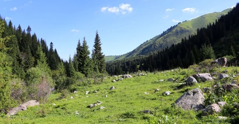
Particularly powerful mountain-building processes took place during the Neogene and Quaternary periods, when the earth's crust was crumpled into folds. These tectonic movements of the Alpine folding formed the modern high-mountain relief of Terskey and Kungey, as well as the Issyk-Kul depression.
Mountain-building processes in the Terskey Ala-Too and Kungey Ala-Too mountains continue to this day, which is reflected in earthquakes in the eastern part of the Issyk-Kul basin, accompanied by avalanches and landslides.
Thus, in the Issyk-Kul region, earthquakes with a magnitude of up to 11 points were noted in 1887, 1889 and 1911.
Along the zone of deep tectonic disturbances, hot mineral springs are observed in the Aksu and Jety-Oguz gorges. Modern mountain-building processes are accompanied by the uplift of the western part of Issyk-Kul, as a result of which, on the western and northern shores, ancient river deltas, having risen, formed long capes and peninsulas, jutting far into the lake near the mouths of the rivers.
On the contrary, in the east the shores of Issyk-Kul are submerged, which led to the flooding of the mouths of Tyup and Dzhergalan and the formation of bays of the same name. From a boat, and sometimes from the eastern shore of Issyk-Kul, as well as on the southern shore near the mouth of the Ton River, the outlines of flooded villages, stone buildings and monuments are visible, which gave rise to legends about a flooded city, a kind of Issyk-Kul city of Kitezh.
To the east of the Turgen-Aksu gorge, the ridge has a height of less than 4,000 meters above sea level and only in the extreme east, near the Semenov glacier, does it rise above 4,000 meters above sea level. There are many relatively low passes here: Ichketash, Mintor, Kash-kator, Ashutor, etc.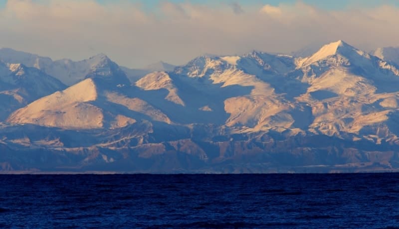
During the Ice Age, the valleys and slopes of the Terskey-Alatau ridges were twice covered by powerful streams of ice. The valleys now occupied by spruce forests were at that time covered with ice, the thickness of which reached 400 - 500 meters.
The glaciers descended to 2200 - 2500 meters above sea level and were 20 - 26 kilometers long. Along the southern slope of Terskey-Ala-Too on the Arabel and Kumtor syrts, apparently, there was a huge, wide glacier that occupied the entire valley, only individual peaks of the ridge rose.
Traces of ancient glaciation have been preserved in the form of troughs - widened trough-shaped valleys with smoothed sides and moraine clusters.
Climate of Terskey-Ala-Too ridge.
The moderate continental climate of the Issyk-Kul basin is the mildest in Central Asia and is due to the influence of non-freezing Issyk-Kul. The lake increases the air temperature in January by about 10° and causes a cool summer, which is so unusual for Central Asia.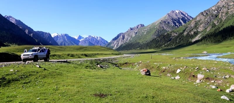
The average monthly temperature in July - August in Karakol (1774 meters above sea level) is 16.5 - 16.9 °, in Jetyoguz (2300 meters above sea level) 13.9 - 14.2 °, in the Chon-Kzylsu gorge, in the area of the Physical-geographical station (2555 meters above sea level), 9.5 - 9.7 °, in the highlands, at the tongue of the Karabatkak glacier (3250 meters above sea level), 6 - 6.2 °.
On the southern coast of Issyk-Kul, vegetables and fruits ripen a month later than in Bishkek and the Chui Valley, the earliest fruits - apricots and plums - appear on the market at the end of August, and the first tomatoes - only in September. During the cool summer, cloudless weather prevails on Issyk-Kul: in June - August in Karakol there are 300 - 320 hours of sunshine, or 67 - 70% of the possible, but in the midlands - in Chon-Kzylsu (2555 meters above sea level) - 190 - 240 hours.
Intensive solar radiation is caused by the high position of the sun: 70 - 72 ° on the summer solstice and 23 ° on the winter solstice. In the Issyk-Kul basin, a warm and dry westerly wind prevails (60%), coming through the Boom gorge and bearing the local name "ulan" or "boom".
The cold eastern wind "santash" sometimes meets over the lake with the western wind and causes the formation of waterspouts. Coastal winds - breezes - are common on Issyk-Kul: during the day they blow from the lake to the shore (locally called "sea wind"), and at night - from the shore to the water ("gornyak"). The same change in wind direction occurs in mountain gorges.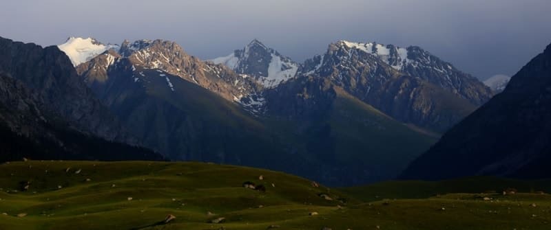
A sharp evening breeze raises high waves on Issyk-Kul, like at sea in bad weather, and a boat caught in the wind can be tossed about by the waves until the morning, because the oars are useless. Precipitation in the mountains of Central Asia is largely due to westerly winds.
At first glance, it seems surprising that air currents arising in the Atlantic Ocean, having traveled many thousands of kilometers and overcome the hot deserts of Central Asia, bring ocean moisture to the Tien Shan and thereby largely determine the nature of the weather in the Tien-Shan mountains.
The air, passing through the Boom Gorge, expands in the Issyk-Kul basin, dries dynamically and takes on the character of a foehn. Passing over the surface of Issyk-Kul, the air masses are again saturated with moisture from the lake's evaporation, and having entered its eastern part, favorable for moisture condensation, they form precipitation, mainly in the warm season.
Due to these features, precipitation in the lake basin increases as it moves from west to east: in the western part (Balykchy) 115 mm per year, in the middle part (Bokonbaevskoye, Cholpon-Ata) 200 - 250 mm, in the eastern part (Karakol) 415 mm, and near the Kungey-Ala-Too ridge (Kurmenty, Tyup) 570 - 676 mm.
Glaciation of Terskey Ala-Too Ridge.
In the eastern part there are over 120 glaciers with a total area of about 80 square kilometers, in the central part - about 500 glaciers with a total area of over 520 square kilometers, in the western part - more than 530 glaciers with a total area of about 550 square kilometers.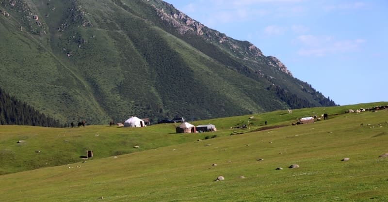
In total, there are more than 1,150 glaciers in the ridge with a total area of over 1,150 square kilometers. Terskey-Ala-Too Ridge, after the Pobeda Peak and Khan-Tengri massif, is the second largest glaciation center of the Tien Shan, with about 1,100 glaciers with a total area of 1,081 square kilometers.
A significant role in the formation of the relief of Terskey is played by ancient and modern glaciation, which caused the formation of troughs - trough-shaped valleys, cirques - bowl-shaped depressions on the slopes of mountains with steep walls, ridges of terminal and coastal moraines.
Heavy precipitation, weak evaporation and low average annual temperatures create favorable conditions in the high-mountain zone of Terskey so that the snow that falls does not have time to melt during the summer and accumulates in the form of firn fields and glaciers.
The snow line, above which the snow does not melt completely even in summer, is located in the northern slope of the ridge, in the eastern part, at an altitude of 3650 meters above sea level, in the western part at an altitude of 3900 meters above sea level, and in the syrty zone, on the southern slope, at an altitude of 4000 - 4270 meters above sea level.
The most developed in the Terskey-Alatau and Kungey-Alatau mountains are valley glaciers, the formation of which is favored by narrow and deep gorges between the parallel lateral spurs of the main ridge, as well as numerous small glaciers and cirques occupying the bottom of the transverse valleys.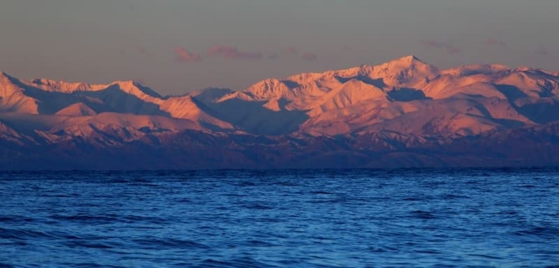
A little more than half of the area of glaciation of Terskey falls on the northern slopes facing Issyk-Kul, where large glaciation nodes are located in the upper reaches of the Turgen-Aksu, Aksu, Arashan, Karakol, Jety-Oguz and Konurulen rivers.
The glaciers of the northern slope of the ridge are bordered by steep snow slopes, reach a length of 5 - 7 kilometers with an ice thickness of 60-90 meters and descend significantly below the snow line - to 2900 - 3500 meters above sea level.
Due to the rocky frame, the tongues of the glaciers are often littered with rock fragments, boulders and rubble. The speed of glacier movement is low, determined by the bottom relief, the size of the glacier and the time of year, and for the glaciers of the Tien-Shan it is only 5 - 15 meters per year, and on the szyrts even less - 1 - 2 meters.
As in the rest of the world, glaciers in Central Asia are retreating: their thickness decreases, the ends of the glaciers are shortened by 3-30 meters per year, zones of dead (motionless) ice are formed, buried under a continuous layer of moraine.
This process began about 50 years ago due to cyclic changes in meteorological conditions. An example of glacier retreat is the unnamed glacier located on the southern slope of Terskey in the Kuyly Valley at the headwaters of the Karakoltor River.
This glacier has decreased by almost 3 kilometers in length, and the melted ice had a thickness of up to 115 meters and a volume of 200 - 250 million cubic meter
Rivers in Terskey-Ala-Too ridge.
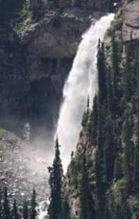
The rivers of the Issyk-Kul basin belong to the endorheic basin, about 80 small mountain rivers flow into the lake, and none of them flows out of it. The Terskey-Ala-Too and Kungey-Ala-Too rivers are mountain streams with a fast and turbulent current, often with rapids and waterfalls; their beds are rocky, full of rock fragments and pebbles.
The valleys of these rivers, located along the lateral spurs, are wide, and the transverse valleys of the tributaries are narrow. The length of the mountain rivers is small, the rivers: Tyup - 101 kilometers, Dzhergalan - 83 kilometers, Dzhuuk - 55 kilometers, Jety-Oguz, Chon-Kzylsu, Aksu and Barskoon - a little more than 40 kilometers.
The Dzhergalan has the most water. Issyk-Kul receives about 80% of its water from the Terskey-Alatau rivers and only 20% from the Kungey-Alatau rivers. The water in the Terskey rivers is very clean and transparent, for example, the turbidity of the Karakol and Chon-Kyzylsu does not exceed 20 g / m3 per year, which is explained by the great hardness and weak erosion of rocks.
The Terskey rivers are of the Tien-Shan type: their greatest flood occurs in July-August, since they are fed mainly by meltwater from high-mountain snowfields and glaciers. In addition to these mountain rivers, the Issyk-Kul basin is characterized by small rivers - karasu, confined to the foothills and fed by 80% by springs.
Geographic coordinates of Terskey Ala-Too ridge: N41°56'19 E77°25'38
Authority:
Series Nature World. "Mountains". N.A. Gvozdetsky, Yu.N. Golubchikov. Moscow "Thought". 1987.
Photos by:
Alexander Petrov.