


![]()
You are here
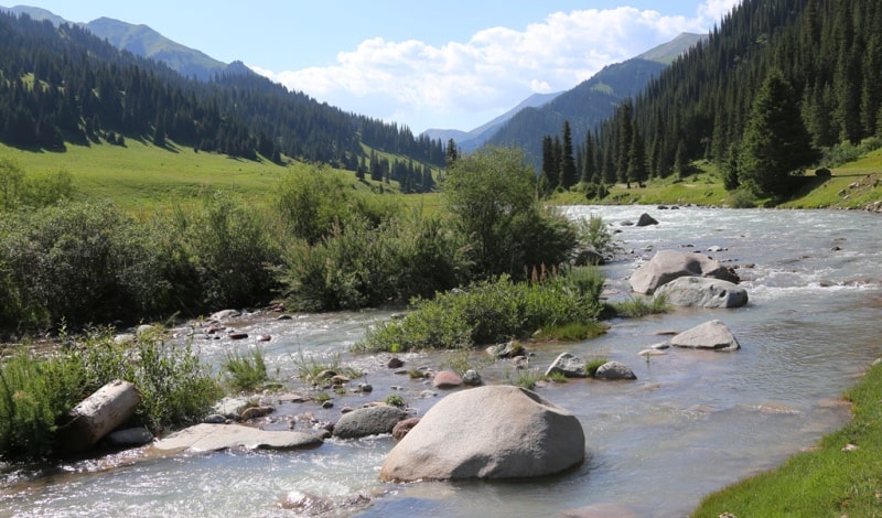
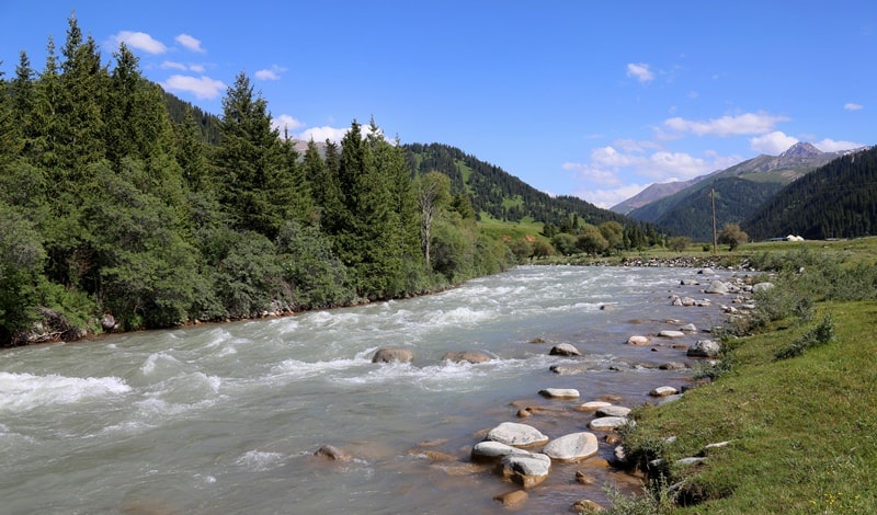
Karkara river in Kazakhstan.
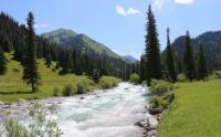
Photo tours across Kazakhstan.
"Water flows down, and a person tends up."
Chinese proverb.
Photos of Karkara River.
The border river Karkara is located on the northern slope, in the eastern part of the Terskey Alatau ridge, flows through the Raimbek and Kegen regions of the Almaty region. Karkara River is formed from the confluence of the two rivers Kokzhar and Turuk.
The eastern tributary of the Kokzhar begins from the northern slopes of the Terskey Alatau ridge on the territory of the Raimbek district of the Almaty region. The western tributary of the Turuk also begins from the northern slopes of the Terskey Ala-Too ridge in the Tyup district of the Issyk-Kul region.
The area of the river basin is 1970 square kilometers, the average annual discharge of water at the mouth is 11.3 cubic meters per second. In the vicinity of the Kyzylmoynok pass with a height of 2801 meters above sea level, first along the Kokzhar River, and then 6.7 kilometers later along the Karkara River, the state border between the Republic of Kazakhstan and the Kyrgyz Republic begins.
On the territory of the Kyrgyz Republic, Karkara flows 32 kilometers from the confluence of the Kokzhar and Turuk rivers. The left bank of the river with tributaries is located on the territory of the Kyrgyz Republic. Karkara is a left tributary of the Kegen River on the territory of Kazakhstan in the vicinity of the Shyrganak (Karkara) village, the mouth is located at an altitude of 1,777.8 meters above sea level. After flowing into Kegen, the river loses its name.
Northwest of the village of Karkara, the Karkara River acquires a flat character and is divided into numerous channels and oxbows. To the north of the village of Buleksaz, in the valley of the same name at an altitude of 1821 meters above sea level, the right channel of the Keshi-Karkara separates from the main channel of the river and at an altitude of 1786 meters above sea level it flows into the Kegen River on the left.
After the Karkara River leaves the mountains, it spreads over the swampy foothill plain, forming meanders that stretch far beyond the Kegen village to the east. It is necessary to pay attention to the repeated names of rivers on Soviet topographic maps, which are present 12.5 kilometers before the exit of Karkara to the foothill plain.The very first sources of the Karkara River begin from the Dzhak River located on the territory of the Republic of Kazakhstan.
Geographic coordinates of Karkara River: N42 ° 51'19 E79 ° 14'19
Jak River.
The southern tributary of the Kokzhar River is the Dzhak River, 14 kilometers long, which originates from the northwestern slope of the Kashkator Pass 3609 meters above sea level. The river receives three tributaries on the right.
The first tributary, 3 kilometers long, the river receives from a swampy lake located at an altitude of 3913 meters above sea level. The second tributary Kokpak, 2.5 kilometers long, the river receives through 130 meters. The stream flows down from the western slope of the Kokpak pass 3482 meters above sea level.
The third unnamed tributary, 4.3 kilometers long, is received by the river 900 meters after the confluence of the Kokpak brook. The tributary originates from the southern side of the unnamed pass 3472 meters above sea level and flows into the Jak at the site of a large camp of local shepherds and shepherds.
Geographic coordinates of Kokpak River: N42 ° 28'40 E79 ° 40'39
Geographic coordinates of Jac River: N42 ° 27'01 E79 ° 39'48
Kokzhar river.
The length of the Kokzhar River is 35 kilometers. The main channel of the river is formed at an altitude of 3009 meters above sea level by the Jak River, which largely fills the river. Passing a height of 3009 meters above sea level, the Dzhak river loses its name, and the river waters get a new name - Kokzhar.
Along its course until the confluence with the Turuk River, Kokzhar will receive 28 tributaries on the right, most of them small and only some significant. After 1 kilometer of its course, the Kokzhar River passes through a small reservoir with a dam located at an altitude of 3014 meters above sea level.
An unnamed 3.2 km long tributary flows into the reservoir on the right. The source of the stream is located at an altitude of 3691 meters above sea level. After 4 kilometers, Kokzhar receives an insignificant tributary-stream on the right. The speed of the river after the confluence of the right tributary of the Kubergena reaches 1.5 kilometers per second.
Geographic coordinates of Kokzhar River: N42 ° 33'35 E79 ° 25'01
Right tributaries of Kokzhar River.
River Kubergeny.
Soon, 7 kilometers after the reservoir, the river receives on the right a 4.5-kilometer long tributary of Kubergena. The river originates from the western slope of the Kubergenti pass, 3570 meters above sea level. The mouth of the river is at an altitude of 2904 meters above sea level.
Geographic coordinates of Kubergenta River: N42 ° 31'04 E79 ° 36'52
Tuz River.
8 kilometers after the Kubergenti tributary, the Tuz River flows into the river on the right at an altitude of 2799 meters above sea level. The Tuz River is 12 kilometers long. One of the tributaries of the Tuz originates from the north-western side of the Tuz pass, 3656 meters above sea level.
The Tuz pass is a watershed between the sources of the Tekes and Tuz rivers. The right tributary begins from the southwestern side of the Kindyktobe pass, 3627 meters above sea level. One of the sources of the Tekes River begins on the eastern side of the pass.
Starting from the source, the river receives 6 small tributaries on the right. The longest is the last tributary in front of the mouth of the river to Kokzhar with a length of 5 kilometers originating from the southeastern side of an unnamed pass 3628 meters above sea level. On the left, the river receives two tributaries, streams.
Geographic coordinates of Tuz River: N42 ° 33'42 E79 ° 32'24
Beytybulak river.
3.5 kilometers after the Tuz River, the 5.4 kilometers long Beytybulak River flows into Kokzhar on the right. The river originates from an altitude of 2902 meters above sea level. The estuary is located at an altitude of 2768 meters above sea level.
Geographic coordinates of Beytybulak river: N42 ° 33'18 E79 ° 28'26
On the right bank, between the mouths of the Tuz and Beytybulak rivers, two tributaries flow into the Kokzhar.
Zharbulak river.
2.5 kilometers after the confluence of the Beitybulak, the Zharbulak flows on the right with a length of 3.6 kilometers. The sources of Zharbulak lie at an altitude of 3286 meters above sea level, the mouth of the river is at an altitude of 2739 meters above sea level.
Geographic coordinates of Zharbulak river: N42 ° 33'44 E79 ° 27'19
Between the mouths of the Zharbulak and Beytybulak rivers, Kokzhar receives three tributaries on the right.
Tiek river.
4.2 kilometers after Zharbulak, the Tiek River, 8 kilometers long, flows into Kokzhar. The sources of the river begin from the southwestern slope of the pass of the same name, 3427 meters above sea level. The mouth of the river is located at an altitude of 2702 meters above sea level. The Tiek River at the mouth has a cone of stone and clay up to 500 meters.
Geographical coordinates of Tiek River: N42 ° 35'00 E79 ° 25'28
Shokmortash river.
9 kilometers after the confluence of the Tiek River, the 5.4 kilometers long Shokmortash River flows into Kokzhar. The sources of the river are located at an altitude of 3794 meters above sea level. The mouth of the river is located at an altitude of 2668 meters above sea level.
Geographic coordinates of Shokmortash River: N42 ° 35'52 E79 ° 23'20
Kyzyltor river.
4.5 kilometers after the confluence of Shokmortash into Kokzhar, the Kyzyltor River with a length of 6.2 kilometers flows into the right. The sources of Kyzyltor begin in the Oklytas Tau mountains in the east from the dominant height of 4019.5 meters above sea level.
The river has three right tributaries originating in the highest part of the Oklitas tau mountains. On the left, the Kyzyltor receives two tributaries, one of which is 5.2 kilometers long and both of them originate in the Tiek Mountains from the southwestern slopes of the peak 4111 meters above sea level. The mouth of the Kyzyltor is located at an altitude of 2578 meters above sea level.
Geographic coordinates of Kyzyltor River: N42 ° 37'46 E79 ° 20'53
Three tributaries flow into Kokzhar on the right between the Shomortash and Kyzyltor rivers. The first two are insignificant, the third tributary, 6 kilometers long, originates from the northern slope of an unnamed peak 3794 meters above sea level.
1.3 kilometers after the confluence of the Kyzyltor with the Kokzhar, in turn, the Kokzhar receives a tributary of the Turuk on the left, hence the river gets a new name - Karkara.
Left tributaries of Kokzhar River.
Ayusai River.
5 kilometers after the confluence of the Kubergenti River into the Kokzhar River, the 8.3 km long Ayusai tributary flows into the left. The main channel of Ayusai is formed at an altitude of 3006 meters above sea level from two tributaries.
The right tributary of the Ayusai begins from a swampy lake at an altitude of 3488 meters above sea level, northwest of the Ayusai peak, 3957.4 meters above sea level.
The left tributary also originates from the northern slopes of the Terskey Alatau ridge. The mouth of the river is located at an altitude of 2834 meters above sea level. The Ayusai River is located on the territory of the Kyrgyz Republic.
Geographic coordinates of Ayusai River: N42 ° 30'32 E79 ° 32'15
Zholdysai River.
After the confluence of the Ayusai River, a tributary of the Zholdysai with a length of 9.4 kilometers flows into the left through 2.7 kilometers. Zholdysai originates on the northern slopes of the Terskey Ala-Too ridge at an altitude of 3487 meters above sea level. The mouth of the river is located at an altitude of 2799 meters above sea level. The Zholdysai River is located on the territory of the Kyrgyz Republic.
Geographic coordinates of Zholdysai River: N42 ° 31'17 E79 ° 31'12
An unnamed left tributary of Kokzhar.
2.8 kilometers after the confluence of the Zholdysai, an unnamed tributary with a length of 7.3 kilometers flows into the left. The main channel of the tributary is formed at an altitude of 2829 meters above sea level from two tributaries.
The right tributary originates from the northern slope of Terskey Ala-Too at an altitude of 3383 and 3373 meters above sea level.
The left tributary originates from the northern slope at an altitude of 3272 meters above sea level. The mouth of the river is located at an altitude of 27668 meters above sea level. The unnamed left tributary of the Kokzhar is located in the territory of the Kyrgyz Republic.
Geographic coordinates of unnamed left tributary of Kokzhar River: N42 ° 31'45 E79 ° 30'02
Kishkene-Orolmo river.
3.4 kilometers after the confluence of an unnamed tributary, the Kishkene-Orolmo river, 6.8 kilometers long, flows into the left. The sources of the right tributary of the river are located on the northern slope of the Terskey Ala-Too ridge, northeast of the unnamed peak 3454.3 meters above sea level.
The left tributary of the river originates from the southeastern side of the Orolmo Pass 3302 meters above sea level. The mouth of the Kishkene-Orolmo river is located at an altitude of 2730 meters above sea level. The Kishkene-Orolmo River is located on the territory of the Kyrgyz Republic.
Geographic coordinates of the river Kishkene-Orolmo: N42 ° 32'27.53 "E79 ° 26'49.70"
Literally 460 meters after the confluence of the Kishkene-Orolmo, the Koyanda tributary, 4.2 kilometers long, flows into the left. The sources of the river are located on the eastern slope of the Koyandy pass, 3202 meters above sea level. The mouth of the Koyanda River is located at an altitude of 2724 meters above sea level. The Koyandy River is located on the territory of the Kyrgyz Republic.
Geographic coordinates of the Koyanda River: N42 ° 32'26 E79 ° 26'07
Karkara river.
Right tributaries of Karkara River.
Sartashu river.
2 kilometers after the confluence of the Kyzyltor into the Karkara River, a 6.5 km long tributary of the Sartash flows into the right. The sources of the river begin from the southern side of the pass of the same name, 3629 meters above sea level. Two left tributaries are formed from the southern slopes of the Oklytas tau mountain range, in the vicinity of the dominant peak 4111 meters above sea level. The mouth of the Sartashu is located at an altitude of 2587 meters above sea level.
Geographic coordinates of Sartashu River: N42 ° 37'14 E79 ° 19'18
Between the right tributaries Sartashu and Kyzyltor, on the right, Karkara receives two small tributaries originating from the southern slope of the dominant, unnamed mountain 3106 meters above sea level.
Sarysu river.
Through 30 kilometers after the confluence of the Sartash tributary into the Karakara, the river receives the Sarysu tributary on the right with a length of 17 kilometers. The sources of Sarysu are located north of the Saryzhailau tract at an altitude of 3327 meters above sea level.
In the upper reaches, the river is formed from 5 tributaries. At an altitude of 2076 meters above sea level, 4.5 kilometers north-west of the village of Mynzhylky, Sarysu receives an inflow from the right with a length of 6 kilometers. The main channel of the river is formed at an altitude of 2030 meters above sea level. The Sarysu estuary is located at an altitude of 1983 meters above sea level.
Geographic coordinates of Sarysu River: N42 ° 46'04 E79 ° 12'56
Between the mouths of the Sartashu and Sarysu rivers, 9 minor tributaries flow into the Karkara on the right.
Kyzylbulak river.
At an altitude of 2030 meters above sea level, the Kyzylbulak river with a length of 8.7 kilometers flows into Sarysu on the left. The sources of the river begin from the northern side of the pass located at an altitude of 2487 meters above sea level. Passing the Sartasu tract, the river acquires a flat character, a meandering channel with frequent meanders.
Geographic coordinates of Kyzylbulak river: N42 ° 44'11 E79 ° 13'25
Kur-Karkara river.
400 meters after the confluence of the Sarysu River into the Karkara, the Kur-Karkara tributary with a length of 21 kilometers flows into the right. The sources of the river begin on the northern slopes of the Oklytas tau mountains from the vicinity of the highest part of the mountain range, 4019.5 meters above sea level and 3584 meters above sea level, which is located to the north-east.
At the exit from the gorge, almost on the flat part, at an altitude of 2,130 meters above sea level, the river flows through the small village of Mynzhylky. The mouth of the Kur-Karkara is located at an altitude of 1981 meters above sea level.
Geographic coordinates of Kur-Karkara River: N42 ° 46'01 E79 ° 15'04
Ak-Karkara river.
4.3 kilometers after the confluence of the Kurkarkar with the Karkara, the Ak-Karkara tributary with a length of 20.3 kilometers flows on the right. The sources of Ak-Karkara begin from the northern slopes of the Oklitas tau mountains at an altitude of 3636 meters above sea level. The mouth of the Ak-Karkara is located at an altitude of 1961 meters above sea level.
Geographic coordinates of Ak-Karkara River: N42 ° 47'06 E79 ° 16'34
River Zhel-Karkara.
4.2 kilometers after the confluence of the Ak-Karkara, a tributary of the Zhel-Karkara with a length of 29.5 kilometers flows on the right. The sources of Zhel-Karkara begin from the northern slopes of the Oklytas tau mountain range, which in turn is located on the northern slopes of the Terskey Alatau ridge.
The right source of the river starts from the northern slope of the highest mountain in this region, Baskarkar, 4059.1 meters above sea level. The left, western tributary begins at an altitude of 3966 meters above sea level. The main channel of the river is formed at an altitude of 2501 meters above sea level. The mouth of the Zhel-Karkara River is located at an altitude of 1927 meters above sea level.
Geographic coordinates of Zhel-Karkara River: N42 ° 49'31 E79 ° 20'05
Kurtubay river.
Through 17.4 kilometers after the source, the Kurtubay tributary with a length of 12 kilometers flows into the Zhel-Karkara on the right at an altitude of 2240 meters above sea level. The source of the river begins from springs at an altitude of 3286 meters above sea level.
Geographic coordinates of Kurtubay River: N42 ° 45'26 E79 ° 23'36
Kainatpa tuz stream..
1.5 kilometers after the confluence of the Zhel-Karkara, a 9-kilometer long tributary of the Kainatpa Tuz flows into the right. The stream originates from the northern and southern sides of the Sarykol village at an altitude of 2094.7 meters above sea level.
The mouth of the Kainatpa tuz stream is located at an altitude of 1924 meters above sea level. 2.8 kilometers before the mouth on the right bank of the stream, at an altitude of 1965 meters above sea level, there are 308 outcrops of natural salt.
meters and a width of 73 meters. Slightly downstream, on the left bank of the stream, there are also salt outlets. Beautiful crystals are found in small puddles and salt deposits.
Geographic coordinates of Kainatpa Tuz stream: N42 ° 51'47 E79 ° 15'46
Keshi-Karkara channel.
To the north of the village of Buleksaz, in the tract of the same name at an altitude of 1821 meters above sea level, the right channel of the Keshi-Karkara with a length of 10.3 kilometers is separated from the main channel of the river. At an altitude of 1786 meters above sea level, Keshi-Karkara flows into the Kegen River on the left.
Geographic coordinates of Keshi-Karkara channel: N42 ° 59'50 E79 ° 06'26
Left tributaries of Karkara River.
Irsu river.
18.6 kilometers after the confluence of the Uchkashka River, the Western Karkara River leaves the Kyrgyz Republic. At 39 km after the confluence of the Uchkashka Zapadnaya into Karkara, the Irsu River, 34 km long, flows into the Karkara on the left, 930 meters east of the Buleksaz village.
The Irsu River is formed from the confluence of two rivers: Taldybulak and Kylchikbai at an altitude of 1965 meters above sea level. On the foothill plain, the river bed is swampy, meandering and has significant meanders. The mouth of the Irsu River is located at an altitude of 1843 meters above sea level.
Geographic coordinates of Irsu River: N42 ° 49'44 E79 ° 08'24
Taldybulak river.
The Taldybulak River with a length of 24 kilometers is the left (western) tributary of the Irsu River. The sources of Taldybylak are located on the eastern slope of Tukumbulak peak 3186.3 meters above sea level. The summit is located in the main ridge, the most eastern end of the Kungey Alatau ridge.
One of the northeastern sources originates from the eastern slope of the small mountain range Saryaygyr at an altitude of 3031 meters above sea level. The dominant height of the Saryaygyr mountains is an unnamed peak 3174 meters above sea level.
At an altitude of 1979 meters above sea level, a tributary flows into the right, originating from the eastern side of the Syptas pass, at a height of 1997 meters above sea level. At the same height, the main channel of the Taldybulak is formed, which flows to the mouth with the Kylchikbay River through a swampy area with frequent meanders in the channel.
Geographic coordinates of Taldybulak River: N42 ° 47'45 E79 ° 04'39
Kylchikbai river.
The Kylchikbai River with a length of 19 kilometers is the right (eastern) tributary of the Irsu River. At an altitude of 1965 meters above sea level, the Taldybulak and Kylchikbai rivers merge to form the Irsu river. The sources of the river are located in the eastern spurs of the Kylchikbay mountains at an altitude of 2381.7 meters above sea level in the Tyup district of the Issyk-Kul region in the Kyrgyz Republic.
The river also receives spring water from the northern slopes of the watershed ridge between the Tyup and Karkara rivers. At an altitude of 2000 meters above sea level, the river crosses the state border between the Republic of Kazakhstan and the Kyrgyz Republic.
Geographic coordinates of Kylchikbai River: N42 ° 47'24 E79 ° 05'27
Zhamanbulak river.
1.5 kilometers before the mouth of the Irsu, on the left, a tributary Zhamanbulak with a length of 17 kilometers flows into the Irsu River. The sources of Zhamanbulak are located on the foothill plain, at an altitude of 2261.4 meters above sea level, 3.7 kilometers northwest of the Boleksaz valley.
The Zhamanbulak bed has numerous meanders on the flat terrain. The mouth of the Zhamanbulak River is located at an altitude of 1866 meters above sea level.
Geographic coordinates of Zhamanbulak river: N42 ° 53'33 E79 ° 06'34
Authority and photos by:
Alexander Petrov.