You are here
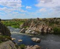
Karskiye vorota on Ishim River.

Natural sights of Ishim River in Kazakhstan.
“Raised by the rays of the rock.
Separately look at the sunset.
The clouds hang wearily
And the drops don’t rustle.
The time of autumn is getting closer,
The heat is getting more and more tiresome.
The day is filled with abundant fluff,
And the night gathers dust until the morning"
Victor Storopov.
Karskiye vorota in Kazakhstan.
“Karskiye vorota” on the Ishim River is located at an altitude of 154 meters above sea level, located on the Ishim River, 10.8 kilometers northwest of Lake Ulykol, 5.4 kilometers southwest of the village of Birlik, 5. 7 kilometers northeast of the village of Toksan bi, in the area named after Gabit Musrepov, in the area named after Gabit Musrepov, North Kazakhstan region.
The Ishim River, at the site of the so-called “Kara Gate,” cut through the bedrock of granite and divided the channel into two channels; a granite island rises in the middle of the river. For a long distance, the banks of the river are framed by rocks; here and there, huge granite boulders with a smoothed surface are scattered, this indicates that the water level rises during floods and the stones are submerged in the water. Juniper grows along the banks, among the stones and on the rocks.
There are several types of fish in the river: tench, pike, carp, ide and others here are favorite places for local fishermen. The ecology of this place leaves much to be desired.
The natural landmark on the Ishim River has nothing in common with the Karskiye Vorota in the Russian Federation, since the Kara Gates are a strait between the islands of Vaygach and Novaya Zemlya (Russia), connecting the Barents and Kara Seas, with a length of 33 kilometers.
It is the passage of the southern route of the Northern Sea Route to Cape Chelyuskin.
Geographic coordinates of “Kara Gate” on Ishim River: N53°00'20.54" E66°39'58.58"
Authority:
Alexander Petrov.
Photos by:
http://visit.sko.kz/news/read/Karskie_vorota_pokazahstanski.html#:~:text


