


![]()
You are here
Kokshetau national park.
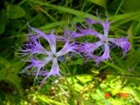
Flower Tours Natural Park Kokshetau.
“You’re frustrated because you keep waiting for the blooming of flowers of which you have yet to sow the seeds”
Steve Maraboli.
Wildlife Tours Natural Park Kokshetau.
National Natural Park “Kokshetau” is established in April 1996. Its basic territory, in 60 km to the south-west of Kokshetau town occupies above 182000 hectares and it includes mountains and forests, as well as lakes of Zerenda, Shalkar, Imantau and Aiyrtau nature zones.
On the whole territory of the park there is the special protection regime, which excludes the damage to the area, which has natural and cultural value. The meaning of the name Kokshetau (formerly Kokshetav) is Blue Mountains, an accurate description, like all Kazakh place names.
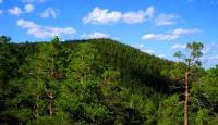
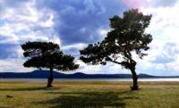
North of Astana, on entering the southern Siberian Lowlands, the steppe changes its visage, becoming a rich landscape of water, hills and forest, a glorious and versatile region that is one of Kazakhstan's most photographed areas.
The area between Astana and Kokshetau is known as the "Kazakh Switzerland", and though its hills can hardly compete with the Alps in grandeur, the picturesque scenery of rocky peaks, forested slopes and jewel-like lakes rightly attracts tens of thousands of holiday-makers from Kazakhstan and Russia throughout the summer months.
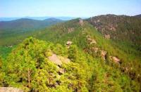
Approximately in hundred kilometers from Kokshetau city there is the massif of the most ancient rocks in Central Asia (eclogites) which are at least more than three and a half million years old. Kokshetausky elevation also has other very picturesque places - Imantau, Zerenda, ArykbaIyk mountains which are also favourite hoIiday spots.
The Kokshetau Park is famous for its many spas and clinics, its kumys, healing mud and mineral water. The combination of mountains, coniferous forests and lakes creates not only a beautiful landscape, but a particularly healthy climate.
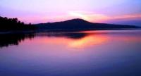
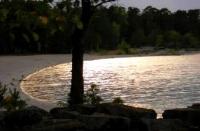
There are over 80 picturesque lakes nestling in Kokshetau's low-lying pine forests. The deepest, Lake Chuchye (18 m), is situated at the foot of the Zheke-Batyr range. This is a great place for fishing: the lakes are full of pike, perch and wild carp.
Here, against the background of the tree-covered Kokshetau mountain, is the crag named Okzhetpes, the top of which resembles an elephant lying down, and Zhum-baktas (the riddle-stone), rising 18 metres from the water.
(See the story in the section on weddings.) The work is conducted for the recreation of ecosystems, which are under the threat of destruction, for the protection of the historical monuments and natural resources, as well as improvement of service provision for the visitors.
Presence of the developed forestry services and posts on the main roads, mobile patrols in the rest areas provides the protection of the area from fire, pollution with wastes, regulates the allocation of the visitors.
The national park is the nature-protective scientific institution, where the goals to preserve nature are combined with the ecological education and holidays of people in the unchanged or slightly changed natural conditions.
It preserves the ideals of natural areas, gene pool of the rare and disappearing species of organisms, unrepeatable natural formations, and flora and fauna resources. Here you can visit interesting landscapes, archaeological and historical monuments, take a horse-riding tour or a yacht-tour, you can purchase the goods produced by the local craftsmen.
All year round you can try meals and drinks of Kazakh national cuisine, Finnish sauna, Russian Steam Sauna. On the lakes of Shalkar, Imantau, Zerenda, even on business days, in the summer time there are around one thousand tourists from Kokshetau and other oblasts of Kazakhstan and Russia.
The town is surrounded by forested, hilly landscape, and in clear weather the blue-tinged skyline of ridges and hills can be discerned on the horizon. Kokshetau is located on the edge of the northern foothills of the low mountain range of the same name.
It is a region rich in forests and lakes, and its highest peak, Mount Kokshetau in the Burabay-Kokshetau National Park, reaches to 947 metres (the Kazakh name Burabay has officially replaced the Russian Borovoye, though you will hear and see both names used).
The town was once the administrative centre of Kokshetau Oblast until the territorial reshuffle of 1997, when the North Kazakhstan Region was created with its administrative centre in Astana. In doing this the new capital gained a beautiful hinterland - and a weekend leisure spot where its resident's could escape the city and relax in natural splendour.
You can still see reminders of Kokshetau's role as a centre of provincial administration. The broad streets with pot-holed pavements are flanked by magnificent Soviet-style buildings, a relief to the eye after the desolate uniformity of multistorey residential blocks.
The many abandoned industrial complexes in the city and on its outskirts contribute little to making the place look more cheerful - Kokshetau has suffered more than many other towns in the north since the exodus to their homeland of a large number of ethnic Russians after Kazakhstan's independence, and the town is estimated to have lost one-fifth of its population.
However, in its new role as a satellite town for Astana, the hitherto rather unlucky Kokshetau hopes to benefit from transit tourists on their way to Borovoye, thus developing its own potential.
Geographic coordinates of Kokshetau National Park: N53 ° 05'51.59 "E68 ° 22'01.04"
Authority:
The guidebook across Kazakhstan. Authors Dagmar Schreiber and Jeremy Tredinnick. Publishing house "Odyssey".2010.
Photos by
Alexander Petrov.