


![]()
You are here
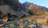
Kulikalon basin.

Nature of Fanу mountains.
"The stars fall at our feet,
We leave our mountains
Carrying soot on the cheeks
Not crashed meteors."
Yuri Vizbor. 1963.
Lakes of Kulikalon basin.
Kulikalon basin is located at an altitude of 2828 to 2873 meters above sea level, located among the Kulikon lakes, in the Artuch river valley, on the northern slope of the Gissar Range, in the eastern part of the Govkhona mountains, in the southwestern part of the Chimtarga valley, in the Penjikent district of the Sughd region.
The Kuulikolon basin is located to the east of the Govkhona mountains, to the north of the Chimtarga valley. The Kulikalon basin is a grandiose beauty, a bewitching sight, which is best observed by climbing the low meadow peak of Mount Fluorite.
The perimeter of the Kulikalon basin is 13,013.75 meters. The basin area is 4.76 square kilometers. Below, on both sides in dense forests, more than a dozen absolutely marvelous lakes, different in size and color, interconnected by a network of small rivers and streams, glisten like fragments of a broken mirror.
The blue expanse of Kulikalon spreads right under your feet, in front, like a gray-haired giant, the top of Ruzerawat rises 3700 meters above sea level. The back is covered by the sparkling snow-ice ridge of the Kulikalon wall reaching a height of 4755.1 meters above sea level.
A system of a dozen small and large reservoirs overflowing into each other friend, flows into the large Kulikalon Lake. The circus of these magnificent lakes, which is framed from the south by high mountains with glaciers and snowfields, indescribably beautiful.
The Kulikalon depression is a cluster of moraine lakes. The highest of them - Dyushakha - are located at an altitude of 3000 meters above sea level under the wall of the Mirali peak, 5106.1 meters above sea level.
Being on Lake Kulikalon, you can make a one-day excursion, passing from the southern tip of the lake to the Temir-Tau pass and going down to the lakes of Dyushakha. On the descent there are smooth slabs sprinkled with rubble.
An unexpected sharp drop in the spur separating the gorges of the Surkhob and Zheltaya rivers created the Zard Pass, which presents an opportunity to cross from the Zheltoy glacier to the glaciers of the Lesser Hansa.
A large glacier covered the entire Kulikalon basin, and it is a continuous bottom moraine. This glacier filled the final moraine at the headwaters of the Artuch River. Retreating and shrinking, the glacier split into two streams.
The moraine lake Kulikalon and several short glaciers in the sinuses of the Kulikalon wall, south of the lake, now remain from the first one. The second stream started from the walls of the Mirali peak. Its terminal moraine is visible above Bibi Jonat Lake.
From this glacier remained the moraine lakes of Dyushakha, the short Maria glacier and the hanging glaciers under the slopes of the Intermediate peak. From the Kulikalon basin you can see a wide view of the walls of the Western Fany Range and the peaks of Mirali, Aurondag, Saryshakh.
The snow-toothed crown of the Great Hansa overshadows Lake Iskanderkul from afar. A more extensive view of the Greater and Lesser Hansa, as well as a significant part of the Eastern Fany Range, opens from the slopes of the Dvoynoy Pass.
Geographical coordinates of Kulikalon depression: N39°15'31.03" E68°11'07.95"
Authority:
"Fan Mountains and Yaghnob". N.V. Paganuzzi. 1968 Moscow. Publishing House of Physical Culture and Sports.
Alexander Petrov.
Photos by
Alexander Petrov.