


![]()
You are here
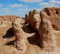
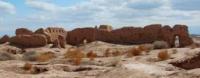
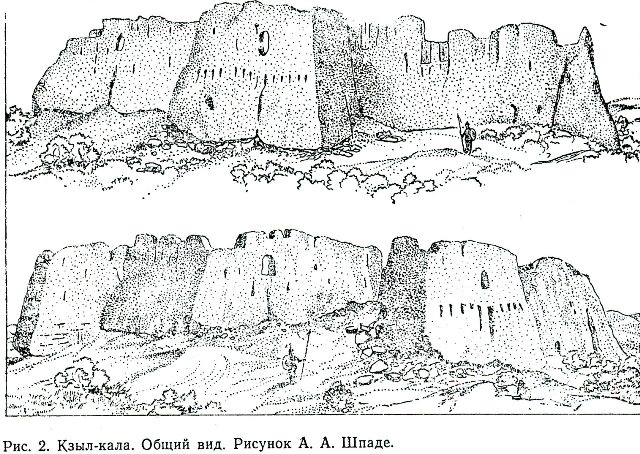
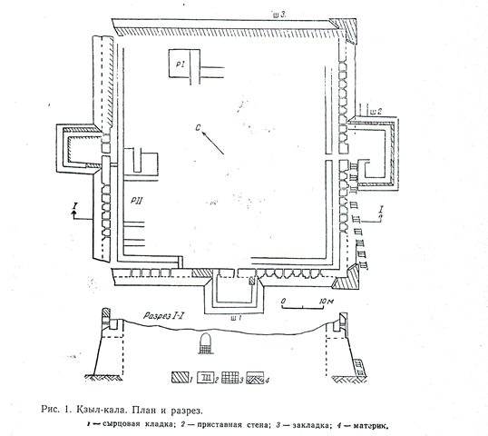
Kyzyl Kala fortress.
Cultural and educational tourism in Karakalpakstan.
“Until the X century, the right bank of the southern Khorezm was the center of the ancient Khorezm kingdom. Here lay the pre-Muslim capital of the country - the city of Kyat. But after the transition of the center of political life to Urgench at the end of the 10th century, this territory recedes into the background and is clearly declining. The residence of the ancient Khorezmshahs - the Fil castle, or Fir, in 997 was washed away by the Amu Darya. In the 12th century, the Arab geographer Sam'ani reports that some cities on the right bank were in ruins, and their area was being plowed up."
Tolstov S.P. "In the footsteps of the ancient Khorezm civilization." 1937 - 1945
Monuments of Karakalpakstan.
The Kyzyl Kala fortress is located 622 meters south-west of the Nuku-Khorezm highway, 6 kilometers north-west of the Shark-Yulduzi village, 14.8 kilometers northwest of the Bustan village and 26.4 to the north and slightly east of the village of Beruni in the Ellikala region of the Republic of Karakalpakstan.
The monument was first discovered by employees of the Khorezm archaeological and ethnographic expedition of the USSR Academy of Sciences under the leadership of S.P. Tolstov in 1938. Architectural measurements and general plan of the fortress were made by the architect V.A. Lavrov in 1940.
In 1981 and 1982, archaeologists of Karakalpakstan carried ou
The walls of the fortress have been preserved quite well, in some places they still rise by 13 - 16 meters. The walls are very carefully built of square raw materials measuring 39 - 40 - 41 x 39 - 40 - 41 cm. Between them, along the entire perimeter, there is a corridor 1 - 1.6 meters wide.
The thickness of the outer wall is 1.6 - 1.9 meters, and the inner wall is 1.1 - 1.6 meters. The outer wall was cut by two tiers of arrow-shaped loopholes. The entrance to the fortress, 1.42 meters wide, is located in the middle of the southeastern wall and is flanked by a gatehouse. In order to get to the gateway, you need to go through the ramp.
The ramp is 26 meters long and 1.55 meters wide. In the middle of the two walls, with the exception of the northeastern one, there are rectangular protruding towers measuring 14 x 8.4 meters and 12 x 10 meters. The external decoration with pilasters has been preserved on three walls (except for the northeastern wall).
In 1982, two excavations were laid, three stratigraphic pits, in addition, surface clearing was carried out. Excavation I was laid along the north-western wall and 4 rooms of the 12th - early 13th centuries were opened, measuring 4.3 meters and 5.35 and 3 meters.
Their walls have been preserved to a height of 0.3 - 0.4 meters. They are made of raw materials, measuring 30 x 30 x 5 cm, and coated with a thick layer of clay plaster. Bins, a tandoor and a horseshoe-shaped ceramic hearth were found in the premises.
Excavation II has partially revealed two rooms (I - II centuries A.D.) adjacent to the northeastern wall measuring 5.1 x 6.85 meters and 2.32 x ? meters. Kyzyl Kala was probably built in the Ist -II2nd centuries. AD as a defensive fortress and was part of the chain of Khorezm fortifications created by the state to protect the northeastern border of ancient Khorezm.
The Kyzyl Kala fortress is located on the territory of Ancient Khorezm (modern Karakalpakstan) and is located in close proximity to the ancient settlement of Toprak-kala. According to some reports, Kyzyl Kala was part of the Toprak Kala fortification system, and served as an additional fortification.
Kyzyl Kala is a monument of the last stage in the history of architecture of ancient Khorezm and can be considered as a prototype of the Afrigid castles corrugated with massive columns. Kyzyl Kala is a unique architectural monument of Ancient Khorezm of the Kushan-Afrigid period of ancient history.
It stands in the middle of the plain, like a guard guarding the pearl of Ancient Khorezm - the Toprak kala fortress. There is a legend that Toprak kalu and Kyzyl kalu are connected by an ancient underground passage.
This is quite possible, since Kyzyl kala performed protective functions. It lasted until the invasion of Genghis Khan, entering the system of fortifications of the Khorezmshah state. At the same time, the fortress was the center of an agricultural area and a junction of caravan routes through the Sultanuizdag mountain range.
In the XII - early XIII centuries, an attempt was made to restore the fortress, apparently connected with the flourishing of Khorezm on the eve of its conquest by the Mongols. During the excavations of Kyzyl-kala, abundant material material was found: ceramic, stone, glass, bronze fragments; the remains of the mural.
About 300 meters to the southeast, the remains of the pipeline were discovered, which can be traced for 5 meters. It was made up of separate ceramic pipes-kuburs, which were inserted into one another, for which one end was narrowed. The pipeline dates back to the Ist - IInd centuries. AD
Geographic coordinates of the Kyzyl Kala ancient settlement: N41 ° 55'48.83 "E60 ° 47'03.61"

Literature:
1. Grazhdankina NS "Building materials for the mausoleums of Mizdahkan". Architectural heritage of Uzbekistan, Tashkent, 1960.
2. Esbergenov H.E., Yagodin V.N. "Some results of the study of Mazara Shamun-nabi." VKK FAN UzSSR, No. 4, 1966.
3. Nekrasov A.A. "Inscriptions on the gravestones of the Mazlumkhan-Slu mausoleum in Mizdahkan." ZKV, vol. U, L. 1930.
4. Pilyavsky V.I. Urgench, "Mizdahkan". M. 1948.
5. Filimonov V.M. "Mazlum-Slu Palace, a unique monument of civil architecture." In the collection: Materials and research on the history and restoration of architectural monuments in Uzbekistan. Issue 1, Tashkent, 1967.
6. Yagodin V.N. "New data on the history of the religion of Khorezm." SE, No. 4, 1963.
7. Yagodin V.N. "To the study of the chronology and topography of the ancient Mizdahkan." In the collection “History, archeology and ethnography of Central Asia”. M. 1968.
8. Yagodin V.N., Khodzhayov T.K. "The necropolis of the ancient Mizdahkan". Tashkent, 1970.
9. Yakubovsky A.Yu. "Mizdahkan Settlement". EKV, vol. U, L. 1930.