


![]()
You are here
Lake Zaysan.


Tours to Zaisan Lake.
"Already along the route, in the labyrinth of cliffs, we encountered, that is, saw or heard, almost all the birds found near Zaysan."
O. Finsch and A. Brehm. Journey to Western Siberia in 1876.
"Simultaneously with the arrival of a steamship on Lake Zaysan and the Black Irtysh, I proposed to move with a detachment along the southern shore of Lake Zaysan and toward the Black Irtysh. The topographic surveys begun in 1862 were intended to be extended north of Lake Zaysan and the Black Irtysh to Srednyaya Bukhtarma and Narym.
I divided the entire area to be surveyed into three sections:
1) the valley of the northern bank of Lake Zaysan,
2) the valley of the Kurchum River, and
3) the valley of the left bank of the Srednyaya Bukhtarma and Narym.
I entrusted the survey of each of these sections to an experienced officer of the topographic corps. Simultaneously with the topographic work, it was planned to conduct astronomical determinations of points on Lake Zaysan."
Ivan Fedorovich Babkov. "Memories of my service in Western Siberia. 1859-1875. Demarcation with Western China, 1869."
Travel to lakes of East Kazakhstan region.
Lake Zaysan is located at an altitude of 390 m. a. s. l. Lake Zaysan, located in basin of the same name, between the Mynrak range in south, Tarbagatai range in southwest, and Bozaigyrkum sands in east, is located in Kokpekty and Aksuat districts of Abai region and Tarbagatai and Kurshim districts of East Kazakhstan region.
Zaysan is the largest lake in northeastern Kazakhstan.
It is no wonder that back in the XVIIIth century, the Siberian historian Tatishchev wrote:
"The Kalmyks call Zaysan a general lake for the sake of grandeur."
History of names of Lake Zaysan.
At that time, the lake was called Nor-Zaysan, and the word zaysan means prince - head of a clan. Its name is associated with both the Mongolian word "saykhan" (beautiful, wonderful) and the Oirot word "zapasun" (fish). The combination of the Mongol custom of naming lakes with praise and the Oirot word gave rise to a legend about the incredible abundance of fish in the lake, which in the distant past saved the local peoples from starvation.
The Mongols and Kalmyks did not eat fish; hunger forced them to catch them. This is where the names Nor-Zaysan, Zaysan-Nor, and Zaasingnor - "beautiful fish lake" - came from. Lake Zaysan was previously called the "lake of bells," apparently for the melodic sound of the waves, reminiscent of the hum of wires, perpetually interrupted by the almost constant winds.
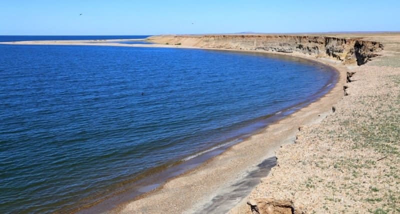
The Chinese border runs 60 km from the lake's eastern shore; the Black Irtysh River flows into Lake Zaysan on the Chinese side. The lake is located at an altitude of 420 m, is 105 km long, and 22-48 km wide, with a maximum depth of 15 m. The ancient Lake Zaysan is located at the bottom of the vast Zaysan Depression, enclosed between the Southern Altai, Saur, and Tarbagatai mountains.
Zaysan is a freshwater lake. The basin area is 1,800 square kilometers, and the depth is up to 10 meters. The lake is a flowing lake, fed by the Black Irtysh, Kokpekty, Zharma, Kendirlik, and other rivers, and flows out only one river, the Irtysh. With the construction of the Bukhtarma Hydroelectric Power Station, the lake's water surface has increased to 5,500 square kilometers.
According to legend, dinosaurs once roamed its shores and the lake. Lake Zaysan is something of a natural paradox. Essentially, it is a vast, flat valley of the Irtysh River. The Black Irtysh, which flows from China, flows into the lake, and the White Irtysh, more commonly known as the Irtysh, flows out.
The Zaysan Valley's climate is desert or semi-desert, hot in summer and harsh, with blizzards and frosts in winter. This is despite the lake being surrounded by mountains on three sides: to the north, the high Altai Mountains with their humid taiga vegetation (mountains up to 4,500 m high); to the east, the Saur Mountains (a spur of Tarbagatai) with larch forests and peaks up to 3,900 m high.
To the south, the lake is bordered by the low, treeless Monrak Range, with peaks up to 2,500 m high. Between these mountains, breaking free from the gorge of the Chinese Mountains, the mighty Irtysh spreads wide and freely, 200 km long and 150 km wide.
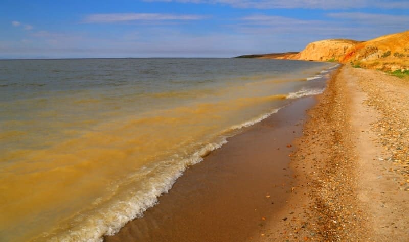
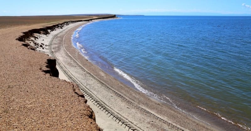
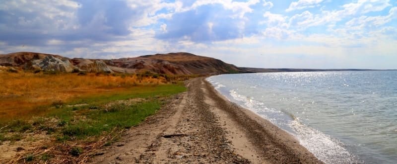
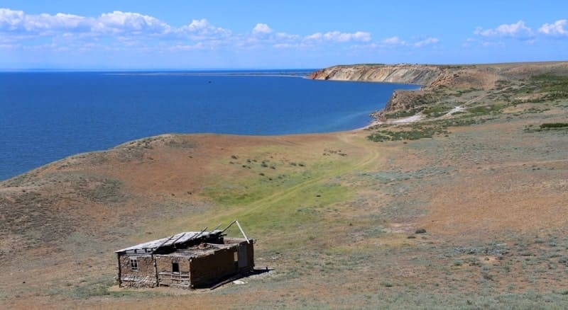
Its shores are mostly flat and low-lying, with only a few isolated hills rising in a few places, serving as beacons of sorts, scorched and baked by the heat and sun. To the north, these are the Chikilmes and Karabiryuk Mountains, and to the east, the Ashutas Mountains.
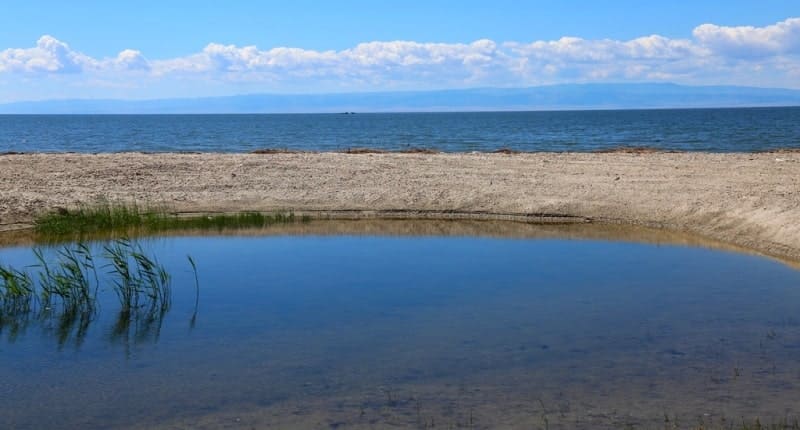
(The word "ashutas" translates as "bitter, salty stone," as it contains ancient charred plant remains and has a sulfurous odor.) The shores are mostly deserted, and due to the water level rising several meters by the Bukhtarma Reservoir, vegetation, even reeds, has not yet formed everywhere.
Only in the east, where the Irtysh River, known locally as the Black River (the water is turbid because it hasn't had time to settle in the reservoir), flows into the lake, its low-lying delta is lushly overgrown not only with impenetrable thickets of reeds, but also, in places (on islands), with groves of poplars and shrubs.
Here, among the yellow water lilies and white water lilies, waterfowl thrive and thrive: cormorants, pelicans, herons, geese, ducks, and other smaller birds, formerly called game. Roe deer and wild boar are found here, and tigers once inhabited it.
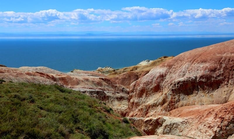
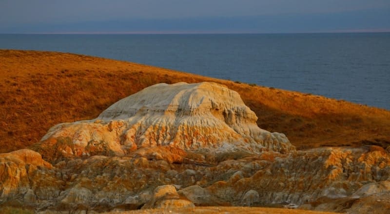
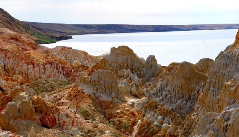
At first glance, the Zaysan Basin is not a particularly welcoming or picturesque place. However, amidst this plain, often dissected by ravines, one can occasionally encounter small lakes and rolling hills composed of multicolored clays - an surreal, almost fantastical sight - true lunar mountains composed of otherworldly rocks.
The aeolian mountains in the Shekelmes tract and near Cape Barkhot on the northern shore of Zaysan are particularly famous among tourists. Silence, broken only by the shrill cries of swifts, the ringing of swiftly flying sajs and bulduruks, and the quiet voices of desert wheatears, reigns in the deserted Kiin-Kerish.
The nests of falcons and mighty buzzards can be seen on the clay cliffs. There's not a trace of humans anywhere, and at first glance, it seems they never set foot here. Stunned by the landscape, tourists even come here from abroad. But how clever nature is: one heavy rainfall and all traces of humans are gone!
They quickly wash away, and the clays once again shine with their pristine purity and untouched beauty. The Zaysan Basin is famous for its rare and even endemic animals (found nowhere else on earth). These include the spotted lizard, the three-toed fat-tailed jerboa (almost the champion among Lilliputian mammals), the extremely rare yellow lemming, Roborovski's dwarf hamster, and the Zaysan round-headed bat.
Marmots, badgers, saker falcons, little bustards, and bustards still live here. Even more recently, in past centuries, herds of saiga antelope, kulans, and Przewalski's wild horses roamed the expanses of the Zaysan Valley (it's worth remembering that it was from the town of Zaysan that Przewalski was given the first specimen of this rare horse's skin).
The history of the exploration and development of Zaysan is closely linked with the names of Russian explorers: N. N. Przewalski, V. V. Sapozhnikov, A. N. Sedelnikov, and others. And in 1876, members of the expedition led by the famous German naturalist A. Brehm repeatedly encountered herds of kulans on the northern shore of Zaysan, even managing to catch a young kulan.
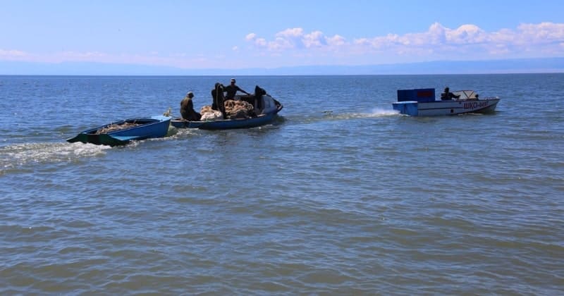
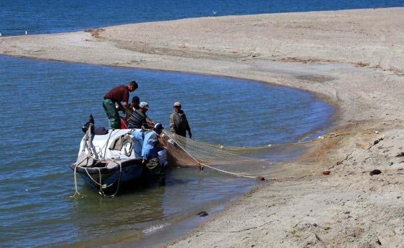
The lake is home to more than 20 species of fish: sturgeon, sterlet, nelma, taimen, carp, ide, tench, pike, perch, and others. A caviar farm is located here. The name Zaysan itself means "noble" - according to legend, this is what the tribes who first came to the lake and found an abundance of fish there, saving them from starvation.
A special place in the study of the lake belongs to the works of G. N. Potanin, who was part of an expedition to Zaysan in 1863. Zaysan is a lake of tectonic origin, formed by the filling of a graben with water. Grabens form in faults in the earth's crust, causing the lake's shores to be steep and sheer.
Zaysan was much larger in the past, as evidenced by traces of surf lines lying well above the current waterline. There is disagreement regarding its age; some suggest that Zaysan formed in the Cretaceous period - at least 60 million years ago.
If so, it would be one of the oldest inland bodies of water that has survived to this day. Most of the lakebed is covered with a layer of silt brought by rivers flowing into the lake from the mountain slopes. There are also isolated sandy and rocky areas, mostly with small pebbles.
The waters of Lake Zaysan make up most of the Bukhtarma Reservoir, formed in 1960. According to a popular version, the first Russian to see Zaysan was the tsar's envoy to China, Fyodor Baikov (c. 1612–1663–1664). Tsar Alexei Mikhailovich, Dissatisfied with the Chinese advance into the Amur region, already settled by the Russians, he decided to settle the matter peacefully (nothing came of it).
In 1654, Baikov and his men left Tobolsk and followed the Irtysh River all the way to Zaysan, which he called Kyzylbash in the Kalmyk manner. The lake's shores were subsequently explored by Nikolai Przhevalsky and, in particular, Grigory Potanin (1835-1920) in 1863.
The history of the lake's exploration and development began in the early XVIIIth century and is closely linked with the names of Russian explorers. Of particular importance in its exploration are the works of G. N. Potanin, who visited Zaysan as part of an expedition in 1863.
Since 1966, when water flow regulation began in the Bukhtarma Reservoir, the water level in Zaysan has risen by 7 meters, doubling its surface area. Recently, ichthyologists discovered crabs in the lake, which had migrated down the Black Irtysh from China.
In the XIXth century, Irtysh Cossacks built special boats, called karbass, specifically for catching sturgeon. The fish were so abundant that children were not allowed near the gear: a strong and large fish could easily capsize the boat and entangle them in the nets.
It is said that particularly large pike were used as poles on the lake ice in winter. The gradual disappearance of pike perch in Lake Zaysan is explained by lucrative orders from Europe for juvenile pike perch, which contain more protein. Legally permitted fish must be at least 38 cm long, but now fishermen are taking any small fish.
In an attempt to preserve the fish in Lake Zaysan, a hybrid fish, the carposazan, was released into the lake.
Geographic coordinates of Lake Zaysan are: N48°04'49 E83°40'43
Authority:
"Zhetysu is Land of tourism”. A Tourist Guide-book. Almaty. 2003. 68 p. and material for this page is taken from printed edition.
Photos by:
Alexander Petrov.