


![]()
You are here
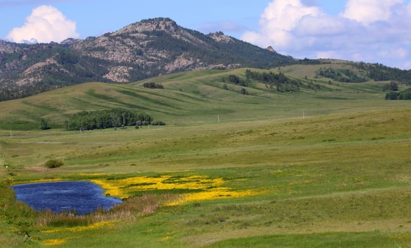
Low mountains of Central Kazakhstan.
Mountains in Central Kazakhstan.
“Life is a continuous ascent along an untrodden path that winds along the mountain slopes ... I stand on a white mountain and look into the blue distance of the roads traveled. Ahead rises a peak under a blue hat of snow. If I manage to climb it - I will see new distances..."
A. Keshokov. "View from the white mountain."
Routes by car in Central Kazakhstan.
Low mountains of Central Kazakhstan, in another way - the Kazakh uplands, are located in the Central part of Kazakhstan on the territory of Akmola, Karaganda, Ulytau and Abai regions and partially captures the western parts of the East Kazakhstan region in the east.
The low mountains stretch from west to east for 1162 kilometers, from north to south the mountains stretch for 636 kilometers.In the area of the Kazakh hilly hills, which occupies most of Central Kazakhstan, against the background of the hills proper, which was formed as a result of small recent tectonic uplifts, deformation and dismemberment of the ancient peneplain, low mountains are located in separate, separate massifs.
Previously, they were considered as the remnants of the denuded Hercynian mountainous country. However, they correspond to areas of recent uplifts - blocky massifs and acticlinoria formed by neotectonics. The axes of the anticlinoria have a wavy profile, which in such cases makes the low mountains discontinuous.
The western and northern parts of the hillock are formed mainly by Caledonian folded structures, the middle and eastern parts by Hercynian. The cores of large massifs of the Caledonian folded zone (Kokshetau, Ulytau) consist of metamorphic rocks of the Archean and Proterozoic, the wings - from the deposits of the Lower Paleozoic.
The large anticlinoria of the Hercynian folded zone (Chingiz and others) have Lower Paleozoic and Proterozoic rocks in their core, while their wings are composed of Silurian and Devonian. The abundance of intrusions and effusions determines the wealth of mountain ranges in ore deposits.
Despite the relatively small heights, the massifs have a typical mountainous relief with strong dissection. Characterized by steep rocky slopes, scree, various forms of weathering. The orientation of massifs and ridges is usually associated with the strike of rocks.
The Kokchetav mountains (Kokshetau) rise in the north of the Kazakh hilly area among the Kokshetau upland, which is based on the ancient Kokshetau block, which is still experiencing tectonic uplifts. The highest peak of the mountains is Sinyukha, 947 meters above sea level.
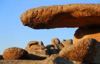
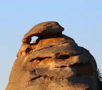
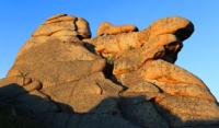
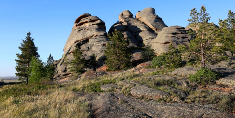
The mountains are composed mainly of granites, the weathering of which creates bizarre landforms, including in the form of mattresses lying one above the other (mattress-like units). As a result of the barrier influence of mountains on the western transport of air masses, the Kokshetau Upland receives more precipitation than the surrounding plains of the steppe latitudinal zone, and forest-steppe, and in the mountains, forest landscapes have formed on it.
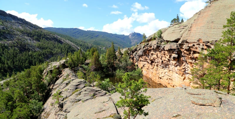
The upland landscapes of granite low mountains are very picturesque. Special beauty is given to them by “deep transparent lakes located at the foot of the mountains and the ruinous relief of weathered granite rocks, forming bizarre statues and chaotic heaps” (Gvozdetsky, Nikolaev, 1971, p. 152).
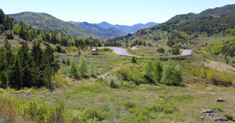
Lake, mountain and forest landscapes of the districts of Shchuchinsk - Borovoe, Zerenda and others are used for organizing tourism, recreation and treatment of workers. The Borovoye resort, located between the lakes Borovoye and Chebachy, enjoys all-Union fame.
In the region of the Kokshetau mountains there are deposits of precious metals and other ores, quarries for the extraction of mineral construction raw materials. Located southeast of the Erementau low mountains (Mount Akdym, 899 meters above sea level), associated with the core of the anticlinorium from Precambrian rocks, with granite and quartzite rocks, it rises among dry steppes with chestnut soils.
But here, forb-cereal steppes develop on mountain gravelly chernozems, thus forming a high-altitude zone of the chernozem stele. Birch and aspen-birch ravine forests are distributed along the logs, beams and at the exit of groundwater near the foot of the mountains.
Located to the south, but in the same tectonic (Caledonian) and latitudinal landscape dry steppe zones, associated with the Hercynian granite intrusions, the Bayanaul (1026 m. a. s. l.) and Karkaralinsky (up to 1403 m. a. s. l.) mountains have a different type of landscape.
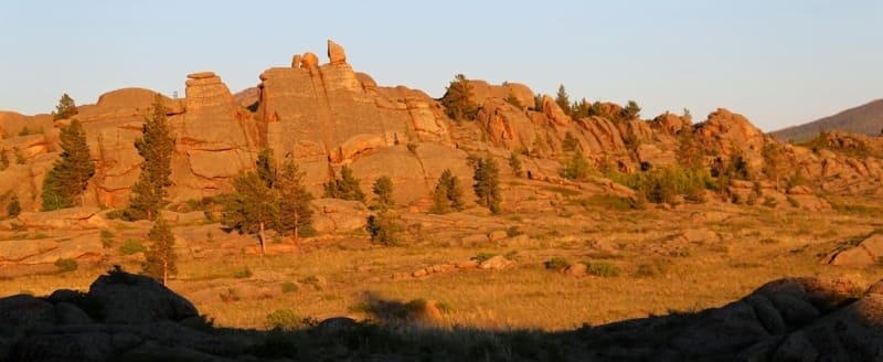
Raised by the latest tectonic movements hundreds of meters and exposed by intense denudation, granite intrusions have given the relief a great picturesque quality. In the intermountain depressions there are transparent lakes, for example, Lake Zhasybai in the mountains of Bayanaul.
Pine forests and light forests grow on bare granite rocks in the Bayanaul mountains with characteristic mattress-like parts. The Karkaraly Mountains have a noticeable landscape asymmetry: their northern slopes are steeper, richer in springs and vegetation.
Located in the depths of the dry steppe of Central Kazakhstan and close to large mining sites, mountain and forest landscapes can be used as excellent places for recreation and tourism. There are deposits of copper and polymetallic ores in Bayanaul and Karkaralinsky districts.
The Ulytau massif is located in the Caledonian folding zone, surrounded by semi-deserts. The highest height of the massif is 1133 m. a. s. l. The mountains are strongly dissected and rocky to the base. The main part of the mountains is composed of collapsing granites and is so exposed by arid denudation that “in many places it appears as a mountainous rocky desert without any developed soil cover” (Gvozdetsky, Nikolaev, 1971, p. 185 ).
Only in the crevices of the rocks sparse sods of steppe grasses, wormwood, small shrubs huddle, and thickets of creeping Cossack juniper and deciduous shrubs settle on large talus consisting of large boulders. The unproductive desert steppe pastures, which are widespread in places, are used for grazing small cattle and camels. In the region of the Ulytau mountains, deposits of iron and ferromanganese ores, polymetals, brown coals are known.
Among the Hercynian folded structures in the center of the Kazakh hilly area are the Kyzyltas mountains, the highest in Central Kazakhstan, with the Aksoran massif rising in the south to a height of 1566 m. a. s. l. Like Ulytau, they are located in a semi-desert latitudinal zone.
Together with the surrounding small hills, lying at a level of 700 - 900 m. a. s. l., the Kyzyltas mountains "form the main orographic and water-separating core of Central Kazakhstan" (Gvozdetsky, Nikolaev, 1971, p. 189). Elevated insular mountains formed by granite intrusions are clearly distinguished here among the mountainous and hilly semi-desert.
As a result of arid denudation, granite rocks are exposed here too, bushes and sods of petrophytes are observed only in crevices, and on rough clastic screes - thickets of Cossack juniper. At the foot of the mountains, along streams and near groundwater outlets, willow, aspen and birch forests grow green.
On the northern slopes of the Kyzylrai granite mountains, areas of pine woodlands have been preserved. There are deposits of polymetallic ores in the region. In the east, among the semi-desert latitudinal zone, stretches the Chingiztau ridge (Mount Kosovo, 1305 m. a. s. l.), also belonging to the region of the Hercynian folding.
It is an anticlinorium elongated from the northwest to the southeast, abruptly breaks off to the northeast and descends in steps to the southwest. The top surfaces of the ridges are leveled, plateau-like. Stony sheep, fescue and feather grass steppes dominate on the flat tops and slopes of the mountains.
The mountain-steppe landscape is enlivened by aspen-birch woods, willow thickets, and along the valleys of rivers and streams and near groundwater outlets - forb-cereal wet meadows. Mountain steppes are mainly used as summer pastures for small cattle.
Geographical coordinates of Kazakh hillock: N48°27'26 E75°29'27

Authority:
Gvozdetsky N.A., Golubchikov Yu.N. "Mountains", series "Nature of the World". Moscow, Thought, 1987.
Photos by:
Alexander Petrov.