


![]()
You are here
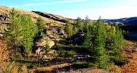
Massif of Yereymentau.


Yereymentau mountains tours.
“I am awfully greedy; I want everything from life. I want to be a woman and to be a man, to have many friends and to have loneliness, to work much and write good books, to travel and enjoy myself, to be selfish and to be unselfish… You see, it is difficult to get all which I want. And then when I do not succeed I get mad with anger”
Simone de Beauvoir.
Excursion tour from Astana to Pavlodar.
Erementau Mountains (from the Kazakh Ereymentau), a low-mountain mountain system is located in the central part, southeast of the Kazakh uplands, in the eastern part of the Akmola region in the Erementau region, the central, small part of the mountains is located in the appendicitis of the Karaganda region in the Osakarovsky region.
The Erementau Mountains stretch from north to southwest for 103 kilometers, the width of the mountain range in the central part reaches 38 kilometers. The highest mark is Mount Akdym, 901 m. a. s. l., the second highest peak is Mount Kunsholgan, 836 meters above sea level.
In the north, the mountains border on the North Kazakh plain, in the south with the small Niyaz mountains, in the east with the Irtysh-Karaganda canal, in the west with the low-mountain ridge of the Falcon Mountains. The Erementau Mountains are connected with the core of the anticlinorium from Precambrian rocks, with granite and quartzite rocks, rising among dry steppes with chestnut soils.
Here, forb-cereal steppes develop on mountain gravelly chernozems, thus forming a high-altitude zone of the chernozem stele. Birch and aspen-birch ravine forests are distributed along the logs, beams and at the exit of groundwater near the foot of the mountains.
The northern part of the mountains consists of several low-mountain spurs: Sharykty with the highest mark Ashchykol 392 m. a. s. l., Kaskaat with a dominant height of 402 m. a. s. l., Baiguly with the highest mark 507 meters above sea level, Mount Sarytobe 338 m. a. s. l., Zhamanadyr with a dominant elevation of 454 m. a. s. l.
A little to the south of the northern part of the mountains there are spurs: Aydarly with the highest elevation of 454 m. a. s. l. and the second highest peak Maltabar with a height of 453 m. a. s. l. and the Koytas mountains with a height of 355 m. a. s. l.
In the central, eastern part of the Erementau mountains, they are supplemented by low-mountain spurs: Ushtagan with a dominant elevation of 361 m. a. s. l., Keregetas with the highest elevation of 461 meters above sea level and Mount Zhamankora 404 m. a. s. l., Mynshukur with a dominant elevation of 555 m. a. s. l., Bozashkyrtau with the highest elevation of 602 m. a. s. l., Karatau with the highest elevation of 661 m. a. s. l., Seriktas with the highest elevation of 507 m. a. s. l., Aigyrzhal with the dominant elevation of 415 m. a. s. l., Seriktas with the highest elevation 507 m. a. s. l., Kalmykozha, Akshoky with a dominant mark 670 m. a. s. l., Belodymovskaya dacha with a dominant mark - Mount Akdym 901 m. a. s. l., the second highest mountain Kunsholgan 836 m. a. s. l. - Terenozek mountains 747 m. a. s. l. and a peak 748 m. a. s. l.
The Erementau Mountains is a mountainous island of rocky hills and mountain ranges bordered by a narrow ribbon of preserved unplowed foothill steppes. It is part of the ancient Timan-Altai mountain system, which in the Pleistocene existed as a single entity and occupied an area stretching from the northeast of the European part of Russia through the southern part of Western Siberia to northern Kazakhstan.
In the Holocene, the Timan-Altai mountain system was separated by geological processes into separate parts and collapsed over a significant extent or covered with sedimentary rock strata. The relic of this system is the Kazakh upland with a heterogeneous geological structure.
There are traces of ancient and young mountain ranges and ridges that cross this elevated massif in various directions. Relic sites of watershed territories of different ages approach it from different sides. They are stretched by lines of hills, sometimes ancient and inconspicuous.
At present, it is possible to single out connections between Yerementau along watersheds with the coast of the Arctic Ocean, with Central Siberia, Altai, Tarbagatai, Dzungarian Alatau, Chu-Ili mountains, Western Tien Shan and the European part of the country.
Geographic coordinates of Ereymentau mountains: N51°23'34 E73°16'54
Authority:
ttp://ereimentau.kz
Photos by:
Alexander Petrov.