


![]()
You are here
Mangyshlak plateau.
Jeep of safari in mountains Mangyshlak Karatau.
“Everything in excess is opposed to nature”
Hippocrates.
Luxury individual and group tours on Mangyshlak.
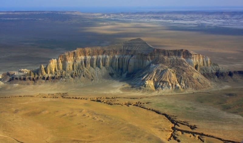
The Mangyshlak highland is located in the northern part of the Mangyshlak peninsula and consists of a number of vast ranges: Western and Eastern, Southern and Northern Karatau, Kaskyrzhol, Ushauyz, also the highlands include individual mountains that are in the system of ranges: Karakyz-Kagakyz, Kaushe, Emdy, meridional mountains Karatau, Karataushyk, Akmaya, Myrzatai. The Mangyshlak Upland is located on the territory of the Mangystau region, Mangystau region.
The wide folded structure of the Mangyshlak Highlands (Mangystau) was formed in the Meso-Cenozoic sedimentary cover of the epihercynian platform in connection with the local uplift of the folded base of the Turan Plate, which is part of this platform.
The base rocks come to the surface in the center of the highlands, making up the low-mountain ridge Karatau, the dominant mark is the highest mountain on the Mangyshlak peninsula - Besshoky, 556.1 meters high above sea level).
In a rough scheme, the plateau is an anticline fold, the core of which is formed by a folded Hercynian basement from Upper Permian, Triassic, and Jurassic rocks. In connection with the immersion and uplift of the fold hinge, three protrusions of the Hercynian base are located along one line - Western, Eastern Karatau and Karatauchik (the westernmost small massif).
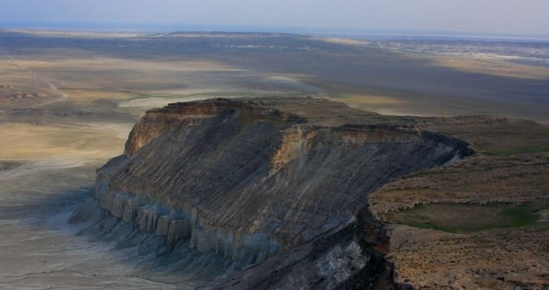
To the north and south of the Western Karatau, monoclinal ridges rise, formed by the Cretaceous rocks of the wings of the anticline. Their ridges and cliffs facing Kara-tau are composed of light Upper Cretaceous limestones, which is why these ridges are called Northern and Southern Aktau (Aktau - "white mountains", Karatau - "black mountains").
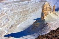
In the longitudinal valleys between the Karatau ridge and the Aktau ledges, Lower Cretaceous clays and sandstone layers with spherical concretions up to 1.5 - 2 meters in diameter (up to 3 meters or more in places) are exposed.
As a result of the weathering of the sandstone and the removal of sand, the concretions were brought to the surface, forming clusters in the form of rows of giant balls, hollow inside when the internal parts of the concretions are blown out.
The Mangyshlak highland is characterized by desert landscapes belonging to the northern zone of the Central Asian deserts. On the most elevated sections of the ridges, not only Karatau, but also Northern Aktau, in accordance with the pattern of altitudinal zonality, the desert landscape is replaced by semi-desert.
The highlands are an important area for the mining industry, and are also used as pastures. Wide folded structures of the Mangyshlak Highlands and Tuarkyr are parts of the Meso-Cenozoic cover of the Epi-Hercynian platform, the formation of which is associated with local uplifts of the folded base of the Turan Plate.
The rocks of this base come to the surface in the center of the Mangyshlak highlands, forming the Karatau mountains, and also to the southeast of it, where these rocks form the Kyzylkiya uplands in the Tuarkyra system.
Outside the folded highlands, Mangyshlak is a low (150 - 175 meters above sea level) limestone plateau with deep drainless solonchak depressions in the south (including the huge Karagie depression −132 meters below sea level).
Large oil fields (Zhetybay, Uzen) have been discovered in the southern Mangyshlak. From the north, the low-lying Buzachi peninsula with sands, clayey plains and salt marshes joins Mangyshlak.
Mangyshlak belongs to the northern desert zone, representing areas of clayey, partly stony, sandy (in the east and northeast) and saline deserts. E. V. Lobova (1960) refers Mangyshlak, as well as most of Ustyurt, to the Turan province of carbonate gray-brown soils.
The northern half of the peninsula (to the north of latitude 44°) is occupied by a typical clayey wormwood desert. The vegetation cover is dominated by Northern Turanian species of wormwood in combination with hodgepodges (biyurgun, boyalych, etc.).
The southern half is dominated by solonchak deserts (with gray-brown solonetsous and gray-brown solonchakous soils), combined with clayey wormwood and solonchak succulent saltwort deserts from sarsazan, saltwort, etc., as well as with devoid of vegetation solonchaks in deep depressions.
In some places, the rockiness of the substrate makes itself felt; it is especially pronounced in the Mangyshlak highland, where the pattern of altitudinal zoning also comes into play. On the highest ridges, the desert turns into a semi-desert.
Geographical coordinates of Mangyshlak Highlands: N44°19'59.94" E51°47'26.50"


Authority:
A.G.Isachenko, A.A.Shliarnikov. The nature of the world. "Landscapes", Moscow, "Idea", 1989. (Andrusov, 1915; Borneman, Spiridonov, 1929; Dolenko, 1930; Rusanov, 1930; Fedorovitch, 1947; Rybin, 1952; Shlezinger, Plecheev. 1959; Kazakhstan, 1969; Faizov, 1970; Geology of the USSR, 1970; Ground of peninsula Mangyshlak, 1974; Bohr, Dzhamalbekov, 1983; Safronov, 1986).
Photos by
Alexander Petrov.