


![]()
You are here
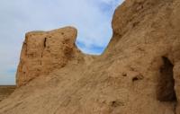
Monshakty-asar settlement (Zhalanashtobe).
Tourist travel in Kazakhstan.
“Narrative history always suffers from imprecision, but it is a portrait. Statistical history will always be just a mechanical imprint"
Anatole France.
Travels across Kazakhstan and Central Asia.
The settlement of Zhalagashtobe (Monshakty asar) is located 3 kilometers north-west of the village of Bukharbay batyr and 11.8 kilometers south-east of the village of Zhalagash and 196 meters north of the highway from the village of Zhalagash - the village of Maddenie in the Karmakchinsky district of the Kyzylorda region.
The Monshakty-asar fortress (Zhalanashtobe) belongs to the groups of "eastern" asars. It is located in a wide valley on the right bank of the Syrdarya River, occupied by arable land. The settlement is a fortified settlement located on a low rounded hill, about 150 meters in diameter and 9 - 10 meters high.
The fortress is a two-tiered round-shaped tobe with a diameter of 60 meters and a height of 6 - 7 meters. In the southern part of the lower tier, rounded pits are traced, 2 - 3 meters in diameter and up to 0.5 meters deep.
Fragments of animal bones and stucco ceramics are found throughout the area. The platform of the upper tier is flat, round, 40 meters in diameter. A triangulation sign is installed at the top of the tobe. The entire territory of the monument is overgrown with dense shrub vegetation.
Geographic coordinates of the settlement of Monshakty-asar (Zhalanashtobe): N45 ° 00'25.39 "E64 ° 33'55.45"
Authority:
https://sketchfab.com/3d-models/098--e9a78589b7e940ec87311037a4cf4887
Photos by
Alexander Petrov.