


![]()
You are here
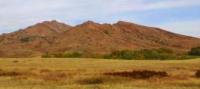
Mount Auliye in Ulytau.
Mountains in Ulytau.
“Naturally, we learn about travels to unknown lands at the dawn of history only if and only where important events have been preserved for subsequent generations in images or writings, whether in the form of inscriptions carved on stone and other testimonies or records made by poets and scientists who mastered the art of writing. However, it goes without saying that both voluntary and forced travel took place long before that time, perhaps at the dawn of human history."
Richard Hennig. "Unknown lands".
Sights of Ulytau nature.
Mount Auliye ata is located in eastern part of Ulytau mountains, 4.3 kilometers to west and slightly south of Ulytau settlement, 27 kilometers southeast of Sarlyk village in Ulytau district of region of name region.
Mount Aulie or Aulietau (that is, the sacred mountain), rises to a height of 1131 m. a. s. l. and attracts pilgrims from all over the country, the number of which, despite almost 400 meters of rise in height, does not decrease and is constantly increasing.
There are many legends and theories associated with Mount Aulie, which speaks of its importance and fame. Some scholars believe that Khan Jochi and his descendants revered Mount Aulie (Ulytau) as the Family Mountain, the worship of which meant a lot to them, even after the rulers of the Golden Horde converted to Islam.
However, archaeologists believe that the mountain had a sacred character already in the Bronze Age. The reason for the interest in the top is that at the height are the burials of seven holy Sufis, most of whom were healers, as well as a cave, which, according to popular belief, has magical properties.
Plates with the names of Sufis were installed on the graves already in our time by one of the residents of the Ulytau village - Bakbergen Ayashev, by the way, a famous healer. Some say that the legendary Asan Kaigy, a Kazakh philosopher and poet who lived in the XVth century, is buried at the top of Aulietau.
Some believe that not far from the cave, located 300 meters away, not reaching the top, his wife is buried. People climb to the top of the mountain by two main routes:
1. From the north-east (you can get to the start of the pedestrian part from the village of Ulytau by car, it will take about 15 minutes (3 km), the road will go west from the village, through a spring, and then south-west) leads to the top the easiest and most affordable route.
The ascent to the top will take about an hour and a half (climb - 388 meters, distance 2.1 km), descent - about an hour. The trail is marked with stones (often just laid out by them), orientation on the terrain will not present any difficulties.
The first part of the path is a rather steep ascent (the main climb occurs here), during which it is necessary to climb the ridge, and then continue moving along the ridge along a very gentle path.
At first, the trail leads to the neighboring peak of Aulie, on which there are two burials, as well as a good observation point, then the direction of movement changes, the trail turns to the south-west, towards the top, on the way branching off to the southeast to the Aulie cave (it is also called the cave Zerdesh-baba).
In front of the top, in a small saddle, there are several burials, and there is also a white metal yurt.
2. From the south-west (before the start of the pedestrian part from the village of Ulytau, you will have to travel by car first 7 kilometers along the asphalt road leading to the Kazakhmys recreation area, and then move off the asphalt in a westerly direction, in order to turn north after 3 kilometers and leave in the gorge, having overcome about 3 kilometers to the parking lot and passed a serious ford across the river, in time it will take about half an hour).
The direct ascent to the top begins from a picturesque meadow, where you need to leave the car, and takes about an hour and a half (climb - about 350 meters, distance 3.1 km), descent - about an hour. The trail is not marked on the terrain, however, the direction of movement is obvious, at first the ascent is carried out almost strictly in the northern direction, right up to the ridge, the reference point on which is a large rock, from which the movement further continues to the northeast, to the very top.
Geographic coordinates of Mount Aulie: N48°38'38 E66°56'47
Authority and photos by:
Vitaly Shuptar. www.guide.kz
Alexander Petrov.