


![]()
You are here
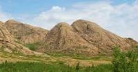
Mount Edyge in Ulytau.
Travel to Ulytau.
“You don't have to live. Traveling is a must."
W. Burrow.
Excursion trips across Ulytau.
Mount Edyge with a height of 1063 meters above sea level is located in the Edyge mountains, which in turn are the eastern spurs of the Ulytau ridge, 16.2 kilometers southwest of the village of Ulytau, 8 kilometers northeast of the village of Korgantas in the Ulytau district of the Ulytau region.
Mount Edyge is composed mainly of granites. The slopes are dissected by small gorges of temporarily operating watercourses. On the slopes there are pine forests and steppe vegetation, in places in humid depressions there are birch groves, in crevices of rocks there are steppe grasses, wormwood, ephedra, and on stony taluses there are shrubs.
On the top of the mountain there are gravestones for Emir Edyge and Khan Tokhtamysh. You can climb to the top of Edyge from two sides:
1. From the north-west (the easiest way to get to the start of the pedestrian part is by car from the Sarlyk village, in the southeast direction, bypassing the Kenenbay reservoir and several fords across the Sarikuz river, as well as the Tokseit wintering place, it will take about 1 hour with 28 kilometers of travel ).
The site where you can leave the car is located 2 kilometers south of the Tokseit wintering area. Direct ascent to the top takes about 1.5 - 2 hours (climb - 420 meters, distance 2.6 kilometers), descent - about an hour.
2. From the southeast (the easiest way to get to the start of the pedestrian part is by car from the village of Ulytau, for which you need to cover about 28 kilometers by car, at first 7 kilometers along the asphalt going south from the village and then along the asphalt going south west from the highway to the Kazakhmys recreation area, and then along the steppe road, about 13 kilometers in the south-west direction and 8 kilometers in the north-west direction, everything will take about 1 hour).
The direct ascent to the top will take about 1.5 hours (climb - 386 meters, distance 2.1 kilometers), descent - about an hour. Both in the first and in the second case, the trail is not marked on the terrain, however, the direction of movement is obvious.
Geographic coordinates of Mount Edyge: N48 ° 34'36.95 "E66 ° 48'58.56"
Authority:
Vitaly Shuptar. www.guide.kz
Alexander Petrov.
Photos by
Alexander Petrov.