


![]()
You are here
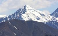
Mountains of Kyrgyzstan.
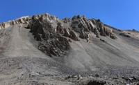
Point of interest in mountains of Kyrgyzstan.
“Nature is an infinite sphere whose center is everywhere”
Ralph Waldo Emerson.
Tours to Kyrgyzstan.
Tien-Shan – is one of six mountain ranges of Asia, mountain system in Central Asia (Kazakhstan, Kyrgyzstan, Uzbekistan, China), 2500 km long.
It is land of rocky canyons, endless ranges armoured by eternal snows, giant peaks, huge glaciers and very cold mountain lakes reflecting in their crystal water a blue sky and mountain forests. Our trekkings cover the territories of Kyrgyzstan and Kazakstan only. The highest points are Mt. Pobeda 7439 m. a. s. l. and Mt. Khan-Tengri 6995 m. a. s. l.
As a whole, climate is continental. The average temperature of July in Low valleys is 20-25 °C; in Middle-height valleys 15-17 °C; at the foot of the glaciers 5 °C and lower. The average temperature of January everywhere except High-altitude regions is – 6 °C and lower.
Over ninety percent of the Kyrgyzstan lies above 1000 meters asl and almost three quarters above 2000 meters. Generally speaking, anything above 1500 meters is counted as mountainous. The country boasts three 7000-meter peaks: Peak Pobeda, Khan Tengri and Peak Lenin, which have been climbed only in relatively recent times.
There are also many virgin peaks yet to be climbed, and some mountains are yet to be given names. There are many distinct mountain ranges which criss-cross the country, dividing it into many distinct regions, each with their own microclimate and ecology.
Most of the ranges vary in length from 100 kilometres to 300 kilometres – the longest, (Kakshaal-Too) is 582 kilometres long and the Kyrgyz Range, lying to the South of Bishkek, is 454 kilometres long. Most ranges are between 10 and 40 kilometres wide.
They form part of two of the world’s mountain systems: the Tien Shan System, (in the north, east and central parts of the country), and the Pamirs, (in the south and West). The Tien-Shan Mountains comprise the largest mountain range in Asia stretching for some 2800 km (at their widest point 800 km wide), with a total of 40 peaks over 6000m.
It stretches across several countries and about much of the system lies in the territory of the Kyrgyz Republic. It is the central portion, south-east of Lake Issyk-Kul which contains the very high mountain peaks such as Khan Tengri and Peak Pobeda, closely grouped together along ridges that stretch east-to-west.
The area surrounding the Enilchek Glacier has two peaks over 7000 meters, twenty three higher than 6000 meters (including 3 virgin peaks) and eighty more peaks between 5000 and 6000 meters (including 14 virgin peaks). The existence of this great range has been known since ancient times.
In fact the southern fringes of the system were first described by the Buddhist monk Hsuan Tsang in the seventh century BC, who wrote of 'encountering nothing but ice and snow. The snow falls both in summer and springtime. Night and day the wind rages violently'.
They also would have been visible to Marco Polo who (if we believe his account) travelled in along this route in 1273, with his father and uncle. However, despite the records and observations recorded by many early travellers until the expeditions of the Russian geographer and explorer Peter Semyenov in the mid-nineteenth century, the Tien-Shan Mountains remained “more legend than fact”.
(Semyenov was granted the honorary title of “Tien-Shansky” by the Tsar for his exploits). The mountains of Kyrgyzstan hold many attractions for mountaineers and trekkers. For most of the Soviet period, (or as some locals refer to it – “in former times”), the region was off-limits to foreigners and even Soviet mountaineers had trouble obtaining the permissions necessary for an expedition.
Although the system is less rigid these days, there are still some restrictions, and permits necessary, in certain areas – especially in the border zones. The difficulties faced by mountaineers are exacerbated by the weather – it can snow suddenly and for several days at a time – increasing the risks of avalanches and crevices.
The ranges which are snow-capped throughout the year are distinguished by the phrase “Ala Too” – although in Kyrgyz the phrase means “many colours” – or “colourful” – or “bright mountains”. The snow-line lies at about 3600 meters.
The relief of the mountains varies extensively from Massif to Alpine and many different types of landscape can be experienced.
Woods tend to be located on North facing slopes, where snow lies longer whilst grassland meadows, (jailoo), tend to be located on southern facing slopes which benefit greater from the warming effects of the sun’s rays.
Authority:
(Abdurashid) “Discovery Travel” Magazine.. www.centralasia.travel
Photos by:
Alexander Petrov.