


![]()
You are here
Mountain system Pamir-Alai.

Tours in Pamir-Alai Mountains.
“Traveling as the greatest science and serious science helps us to find ourselves again”
Sights of Pamir-Alai Mountains.
This mountain system, which includes the highest mountains in Kyrgyzstan, Tajikistan and Uzbekistan - the Pamir Highlands, is located between the Ferghana Valley in the north and the upper Amu Darya (Pyanj - Wahandarya) in the south.
Most of it is located within Tajikistan, the north-eastern part refers to Kyrgyzstan, the western - to Uzbekistan.
The eastern and partially southern edge of the Pamir Highlands enters foreign territory (in China and Afghanistan). Almost all of the Pamir mountain ranges stretched in the latitudinal direction. But there are two large ridges located perpendicular to them - in the meridional direction.
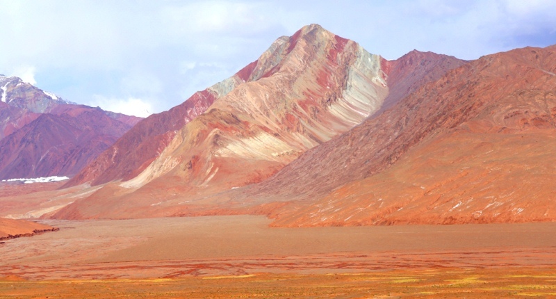
The latitudinal ranges of the Western Pamir are separated from the highlands of the eastern Pamir by the Zulumart meridional ridge, or rather, an entire system of ridges stretching west of Lake Karakul. At the same time, the mountainous region west of Lake Karakul and approximately to the ridge of the Academy Nauk is, as it were, transitional from the rounded contours of the relief characteristic of the central Pamir to the highland relief of its western part with sharp peak shapes and deep river valleys.
Another meridional ridge - the Academy of Sciences also serves as a boundary - it shares the Fedchenko Glacier basin and the upper reaches of Darvaz and Vancha.
Relief and geological structure of the Pamir-Alai.
The northern ranges of the Pamir-Alai system are the Alai and Turkestan ranges that border the Ferghana Valley from the south. Both ridges are noticeably asymmetric: their southern slopes are steep, the northern ones are accompanied by advanced ridges (Kichik-Alai, i.e., Small Alai, and others).
From the line of the Alai and Turkestan ranges in the area of the Matchinsky mountain junction (altitude more than 5600 meters above sea level), the Zeravshan ridge leaves, which stretches west to the south of Zeravshan.
Alai, Turkestan and Zeravshan ranges carry numerous glaciers. These ridges are characterized by serrated ridges, sharp peaks, mountain glacial landforms. An exception are the western parts of the Turkestan and Zeravshan ranges, average heights and mostly flat tops.
Here, due to less elevation, ancient alignment surfaces have been preserved. In the westernmost spurs of the system of northern chains of the Pamir-Alai (the Nuratau ridge and others), ancient alignment surfaces are also traced, raised due to tectonic movements and dissected by younger gorges.
From the high icy ridge of the Zeravshan ridge, a powerful Gissar ridge leaves from the southern side. This entire system of the northern Pamir-Alai ridges belongs to the zone of Hercynian folding. Their geological history is identical to the geological history of the southern spurs of the Tien-Shan.
These ridges of the so-called Gissar-Alai system are composed of sedimentary and metamorphic rocks of the Paleozoic with the inclusion of large intrusions (granites, diorites). The modern relief of the ridges is the result of the latest uplifts occurring in the Neogene and Quaternary.
The studies of N. A. Gvozdetsky in the northern advanced parts of the Alai ridge, the western part of Turkestan and in the extreme western spurs of the entire system showed that the concept of S. S. Schulz is applicable to the northern Pamir-Alai ridges, as well as to the Tien-Shan that the tectonic formation of the relief is associated with the formation of folds of large radius.
In the Paleozoic limestones of the northern Pamir-Alai ridges, karst phenomena are developed, mainly caves (Kan-i-Gut cave with huge halls in the northern front ridge of the Turkestan ridge, caves in the advanced parts of the Alai ridge and in the Osh mountains of southeastern Ferghana).
In the western part of the Zeravshan Range, southwest of Urgut, a typically pronounced karst landscape with craters is observed, similar to the landscape of Crimean caves. Here, on the Kirktau plateau, recently discovered the deepest in Central Asia, 950 meters deep and one of the deepest karst abyss in the world in Kiev.
The areas of the Pamir-Alai, located south of the described Gissar-Alai system, are heterogeneous in tectonic respect. To the south of the Gissar Range is the West Tajik Depression (it is also called the South Tajik). In the west, it is bordered by the spurs of the Gissar Range.
Most of this territory, according to modern concepts, belongs to the Epigercin platform and has the folding of the Mesozoic and Cenozoic cover associated with movements along the fault lines of the Hercynian base.
These faults and folds of the Mesozoic and Cenozoic cover extending from the northeast to the southwest do not coincide with the latitudinal strike of the Hercynian base structures, but correspond to the strike of the structures of the western part of the adjacent Pamir region of the Alpine geosynclinal region (Cenozoic geosynclinal Tethys) their education.
Only comparatively a narrow strip in the east of the depression (and not the entire depression, as before) is now attributed to the zone of the Pamir marginal trough of the Alpine geosynclinal region.
In the West Tajik Depression, there are many relatively low folded ridges stretching from the north-east to the south-west and south-south-west, slightly curved and convex to the north-west. Ranges are composed of Mesozoic (mainly Cretaceous), Paleogene and partially Neogene sedimentary strata with a large role of carbonate and sand and clay motley colors of rocks.
Structural relief forms are typically expressed, especially cuestar ledges. The valleys, slopes, and often the crests of the ranges are composed of terraces. In limestone, gypsum and saline rocks, karst phenomena are developed.
Significant sizes (up to 3 kilometers of total length) and drip and drip formations of gypsum and marble onyx stand Karlyuk caves in the Kugitangtau ridge. The folded structures of the Pamir region of the Alpine geosynclinal region are separated from the Hercynian structures of the northern tectonic zone of the Pamir-Alai by a system of deep faults, which are associated with earthquakes of the Surkhob valley. Blockages - deposits of deadly rocky mudflows, breakdowns and landslides of the earthy weathering crust - were buried during the 1949 earthquake in the ancient Tajik city of Khait and the villages of the Yasman Valley.
In the Pamir region of the Alpine geosynclinal region, several tectonic zones are distinguished, which extend almost latitudinally, but in the west (in the area of the Peter the Great and Darvaz ranges) they deviate to the south, forming an arc facing the bulge to the northwest.
The outer zone of the Pamirs is formed by continental lagoon, less often marine sediments of the Mesozoic and Cenozoic up to 8 - 10 kilometers thick. In the lower Mesozoic, effusives are developed. Sedimentary strata participate in intense folding, numerous formations.
The Northern Pamir is composed of sedimentary metamorphic and volcanic rocks of the Paleozoic with Hercynian intrusions of granitoids. This is a large anticlinorium with anticlinal and synclinal structures of the second order.
The Central Pamir is characterized by the presence of almost all systems of the Paleozoic and Mesozoic, while the Mesozoic is represented by marine (including carbonate) and lagoon and continental fractions. There are volcanic and sedimentary deposits of the Paleogene. Intensive development, complex folding affected not only the Mesozoic, but also Paleogene deposits. Arrays of granitoids are mainly of late Mesozoic age.
The Southwestern Pamir is formed by deeply metamorphosed Precambrian rocks - gneisses, crystalline schists, marbles, granitoid intrusive bodies. This zone is a large anticlinorium. The Southeast Pamir is an area of development of the Upper Paleozoic and marine Mesozoic with significant participation of limestone.
The sedimentary strata form relatively simple folded structures, elongated to the east-southeast and complicated by longitudinal surface formations (M.V. Muratov and I.V. Arkhipov, 1961). B.A. Petrushevsky (1961) includes the South-Eastern Pamir in the Central zone, which he calls the Middle Pamir Synclinoria, while the South-Western and Northern Pamirs calls the South Pamir and North Pamir meganticlinorium zones.
Thus, the ancient Pamir rocks (gneisses with crystalline schists and Paleozoic sedimentary-metamorphic strata) are confined to uplift zones, i.e., they are exposed in the highly elevated anticlinor kernels of the Alpine geosynclinal region.
The Cenozoic fold-forming movements of the Alpine geosynclinal (Cenozoic geosynclinal Tethys) were accompanied by powerful uplifts and denudation of folded ridges, which created a modern relief. The ridges of Peter the Great and Darvaz directly belong to the Pamir Highlands, including their eastern parts, and belong to the two northern zones of the Pamir region of the Alpine geosynclinal region.
The ridge of Peter the Great is composed (with the exception of the eastern section) of the Mesozoic and Cenozoic sediments. Its northern slope has clear levels of leveling surfaces, on which karst phenomena (in Mesozoic limestone and gypsum) are clearly expressed in many areas.
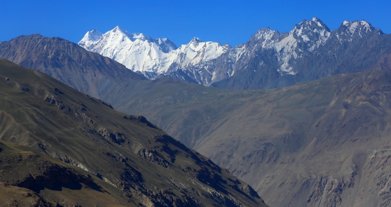
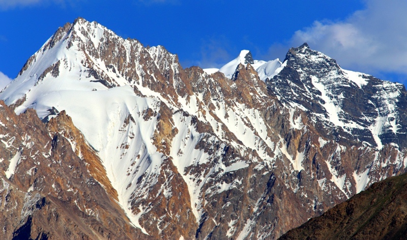
The Pamir Highlands, or the Pamir proper, is located in the east of the Pamir-Alai mountain system, south of the Alai valley that separates the Alai and Zaalai ranges. On the Pamir map, it has the characteristic shape of a quadrangle.
The greatest heights are located at its edges. The northern border of the Pamirs is best carried along the foot of the Zaalai ridge, the southern border along the Pyanj and Vakhandarya rivers (attaching the entire Vakhan ridge to the Pamir), then along the left source of Tashkurgan. In the east, the Pamir includes the Sarykol Range and the Kashgar Mountains with the highest altitudes in the entire Pamir (the peak of Kongur is 7,579 meters above sea level and Muztagata peak is 7,555 meters above sea level.
In the west, the border should be drawn along the Panj valley and then north of the main bend of the river ( a little east of 71 ° E) so that the highest, eastern, parts of the Peter the Great and Darvaz ranges belong to the Pamir.
The Zaalaysky ranges in the north, Kashgar and Sarykolsky in the east, Vakhansky and its western extension - the Shahda ridge Rinsky in the south, the high ridges of the Western Pamir, abutting against the ridge of the Academy Nauk, form the elevated edges of the Pamir Highlands.
Some researchers (KV Stanyukovich, E. M. Murzaev) suggested that the Pamir be called only its eastern half, based on the peculiarity of its landscapes and referring to one of the first researchers of the Pamir - the geologist D. L. Ivanov.
However D. L. Ivanov does not belong to the priority in the study of the Pamirs, and his article “What should I call the Pamirs?” (1885) refers to the time when the mountains Central Asia were still about Shade poorly understood and when it was not only natural but also the inevitable inconsistency in the use of their own geographical names.
However, after the territory was covered with topographic surveys and more correctly depicted on geographical maps, the signature "Pamir" lay exactly in the quadrangle, the borders of which we just outlined, and laid, of course, not by accident.
Despite the sharp differences in the relief of the Western and Eastern Pamirs, the Pamirs clearly acts as an integral orographic unit, the commonality of which is manifested in the eccentric arrangement of the highest heights (K.K. Markov, 1935), i.e., in the elevation of the mountains along the outskirts of the Pamirs.
And if in later studies it turned out that the Eastern Pamir in its natural features is very different from the neighboring mountainous regions, in particular the Western Pamir, it would seem that there should be only one conclusion from this - to single out the Eastern Pamir as a special physical and geographical region without confusing the use of geographical names.
We must also bear in mind the dismemberment of the eastern edge of the Pamir - Kashgar Mountains and note that the name "Eastern Pamir" is used rather conditionally, only in relation to our territory of the Pamirs.
If we take the Pamir Highlands as a whole with its foreign eastern part (with the Kashgar Mountains), then the well-known symmetry will be restored and the Eastern Pamir will soon become Central, as some researchers call it (K.K. Markov, O.E. Agakhanyants).
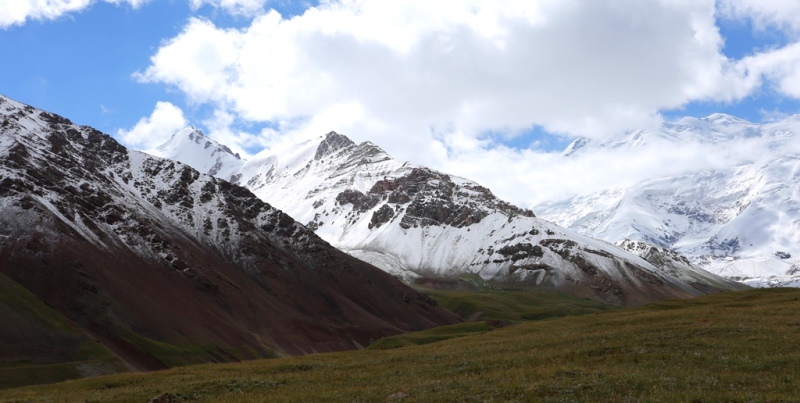
The strongly icy ridge of the Zaalai ridge rising in the north of the Pamirs (Lenin peak is 7134 meters above sea level) significantly exceeds the Alai ridge stretching north and other ridges of the Gissar-Alai system. N.L. Korzhenevsky calculated that the average height of the ridge Zaalaysky ridge even surpasses the ridge of the Academy Nauk and is, therefore, the highest ridge of the Central Asian part of the Pamirs.
In the eastern part of the Zaalaisky ridge, a road was laid through the notch of the Kyzylart pass leading into the Eastern Pamir and further west to Khorog (Osh-Khorog tract).
The Zaalaisky ridge, belonging to the external tectonic zone of the Pamirs, is composed of Mesozoic and Cenozoic deposits. Gypsum karst is quite widespread on its northern slope and at the foot. The internal territory of the Pamirs, lying south of the Zaalai Range, according to orographic features, is sharply divided into two parts: the Western Pamir and the Eastern Pamir, conditionally called by tradition.
The Western Pamirs are characterized by a system of high ridges of a southwestern and almost latitudinal direction, separated by deep valleys and gorges.
These are the ridges of Peter the Great and Darvaz (their eastern segments), as well as Vanchsky, which are connected in the east with the meridional ridge of the Academy of Sciences; to the south - the Yazgulemsky, Rushansky, Shugnansky and Shakhdarinsky ranges.
The northern of these ranges and the ridge of the Academy of Sciences belong to the tectonic zone of the Northern Pamirs, Vanchsky, Yazgulemsky - to the Central Pamir, the last three ranges - to the South-Western.
In the Western Pamirs is the highest peak in Central Asia - the Peak of Communism, 7495 meters above sea level, rising in the ridge of the Academy of Sciences at the junction of the Peter the Great ridge. This peak rises next to the Fedchenko Glacier, the largest in the region and one of the largest mountain valley glaciers in the world.
At the junction of the ridges of Peter the Great and the Academy Nauk is the Pamir firn plateau - the remainder of the ancient leveling surface, raised to a height of more than 6000 meters above sea level. Of the southern ranges of the Western Pamirs, the highest are Rushansky (Pathor peak - 6080 meters above sea level) and Shakhdarinsky (Karl Marx peak - 6726 meters above sea level).
Erosive, gravitational and other denudation processes in the Western Pamirs reach exceptional intensity. The Eastern Pamir is characterized by completely different orographic features. Here, essentially in the central part of the highlands, the ancient relief is well preserved (K.K. Markov, M.V. Muratov), while on the western and eastern outskirts of the Pamirs - in the Western Pamirs and Kashgar mountains - it is mainly destroyed by a deep cutting from the edges of mountain gorges and glacial and nival processes.
The relief of the Eastern Pamirs is characterized by flat bottoms of vast valleys and hollows, raised to a huge height - 3500 - 4500 meters above sea level. Ranges and mountain ranges rise above them, sometimes reaching heights of more than 6,000 meters above sea level (the peak of Soviet Officers on the Muzkol Range is 6,233 meters above sea level).
In the north-eastern part of the Pamirs there are large flat drainage basins with lakes. The basins and wide flat valleys of the Eastern Pamirs are filled with products of mountain destruction - fine earth, gravel, pebble, sand, piles of ancient moraines.
Permafrost is found in soils. The slopes of the mountains are dressed with rubble and eluvial boulder loam (K.K. Markov, 1935). Ranges dividing wide valleys, with enormous absolute heights, are often named relatively small relative heights and resemble the mid-mountain ranges.
The highest ridges have sharp mountain glacial forms (this is a young structure against the general background of an ancient relief).
In the Eastern Pamirs, the Karakul Lake basin belongs to the tectonic zone of the Northern Pamirs, the Muzkol Range and the Rangkul Lake region belong to the Central zone, the Oksu River basin belongs to the Southeast Pamir zone.
In different regions of the Eastern Pamirs (basin with lakes Shorkul and Rangkul, Nizatash pass) among the mesoforms of the ancient relief, limestone remains attract attention that N. A. Gvozdetsky is inclined to consider as relict forms of the tropical karst formed in the Oligocene and, possibly, in Miocene in climate and savannah landscape.
So, the Pamir-Alai mountain system is heterogeneous in surface structure. Northern chains (Gissar-Alai system), closest resembling the Great Caucasus in terms of relief and glaciation forms. West Tajik depression with relatively low ranges and structured landforms.
Powerful Zaalaysky ridge and strongly dissected and high Western Pamir. The high, less dissected highlands of the Eastern Pamirs are all different geomorphological regions. The main orographic units are the Gissar-Alai system, the West Tajik Depression and the Pamir.
The climate of the Pamir-Alai mountain system. In climatic terms, the Pamir-Alai is also heterogeneous, although all of it is in the subtropical zone. Huge heights causing high-altitude climatic zonality, and sharp differences in the distribution of moisture associated with the directions of moist air currents and orographic barriers, cause climatic contrasts.
In the western part of the Pamir-Alai, on the Gissar Range, up to 1,500 mm or more of precipitation falls annually, and forests from walnut and maple grow there, while in the Eastern Pamir, only about 100 mm of precipitation falls and it is characterized by the most Desert alpine landscapes you can imagine.
The climate of the Pamir-Alai is formed under the influence of: continental tropical air formed in the summer over Central Asia and the neighboring Iranian highlands, continental air of temperate latitudes formed in the winter over Siberia and Central Asia.
Cyclones of the Iranian part of the front are of moderate latitudes (in the low and mid mountain tiers), constant western moist air currents in the higher layers of the atmosphere (from an altitude of about 3000 meters above sea level).
Due to the nature of the atmospheric circulation, precipitation occurs most in the western part of the mountain system and mainly on the western and southwestern slopes, while the eastern slopes and the valleys and plateaus lying behind them are in the rain shadow.
The contrasts in the distribution of precipitation over comparatively short distances are striking. So, even in the depths of the mountain system, on the Fedchenko Glacier, due to the barrier effect of the Academy of Sciences ridge and adjacent ridges, giving an impulse to rainfall, the annual rainfall reaches 2236 mm, and only a few tens of kilometers to the east, in the regions of the Eastern Pamirs , their number, as we have seen, is negligible.
In the highlands, especially much rain falls where latitudinal and sub-latitudinal ridges converge to the east, forming a kind of trap for western air flows. Large glaciers originate in such places (Zeravshansky, glaciers in the upper reaches of the Obihingou River - Garmo, Gando, etc.).
In the middle mountains, under the influence of cyclones of the Iranian branch of the temperate latitude front, more precipitation falls on the south and south-west side of the mountains, however, due to the southern exposure, there is more insolation, so it is often necessary to see more dense forests on the northern slopes.
According to the nature of climatic processes, mid-mountain and especially low-mountain regions have much in common with neighboring desert regions. In winter, however, since intrusions of cold air do not spread above 500 - 600 meters, it is warmer in the mountains than on the plains, i.e. a temperature inversion occurs, and when cyclones pass and heavy precipitation occurs on the southern and south-western slopes of the mountains on the northern slopes phenov phenomena develop. In the spring, as in the southern deserts, as a result of increased cyclonic activity, rains often continue, which continue even in the beginning of summer.
The maximum rainfall here is spring, winter-spring, spring-summer. Drought in the mountains begins only in the second half of summer, since the rains here stop much later than on the plain. Before the onset of drought, ephemeral vegetation develops in the foothills and low mountains.
The duration of drought in the mountains is much shorter than in the desert plains, only August and September are sharply arid. In these months, the vegetation burns out and goes under the snow cover of the winter season much more dried up than in the Tien-Shan, where in summer there is a maximum of rainfall and the vegetation does not stop until the autumn snowfalls.
Only in the Eastern Pamirs, in contrast to the rest of the Pamir-Alai, is a summer maximum of precipitation observed, which is explained by the influence of circulation processes developing over Tibet (B.P. Alisov, 1956), or by the action of the South Asian monsoon (O. E. Agakhanyants, 1965 ) As in the Tien-Shan syrts, summer precipitation often falls in the form of cereals and snow.
In the foothills of the Pamir-Alai and in the low mountains, winters are relatively short and mild, summers are long, with high temperatures; rainfall is greater than in neighboring deserts (350 - 700 mm per year). At altitudes of 1,500 - 3,500 meters above sea level, the climate already has the characteristic mountain features, it is cooler and more humid in the predominant part of the territory. Within these altitude ranges, there is a belt of greatest moisture and in some places precipitation exceeds 1000 and even 1600 mm per year. In the Eastern Pamirs, the climate is very dry, sharply continental and severe (at an altitude of about 4000 meters above sea level, the average January temperature is −20 °, July 8 °). In the valleys of the Western Pamirs, temperatures are higher (at an altitude of about 2100 meters above sea level, the average temperature in January is −7.4 °, July 22.5 °) and, although not the same as in the Eastern Pamirs, it is still very dry (annual rainfall is less than 260 mm), in the highlands of the Western Pamirs, much more precipitation falls, especially in the north.
Glaciation of the Pamir-Alai mountain system. The snow line in the Pamir-Alai mountains rises in the direction from west-north-west to east-southeast. On the Turkestan ridge, it is located at an altitude of about 3,500 meters above sea level, in the area of the Fedchenko Glacier - 4,400 meters above sea level, in the central and eastern regions of the Pamirs it rises to 5,200 - 5,240 meters above sea level. The height of the snow line more than 5000 meters above sea level is characteristic only for the tropics and is due to the extreme dry climate here.
In the northern chains of the Pamir-Alai, the greatest glaciation is observed in the Matchinsky mountain junction. The Zeravshan glacier (in the upper reaches of Zeravshan) has a length of about 25 kilometers here.
The icing of the Pamirs is grandiose, especially in the northern and northwestern parts. About 7000 glaciers are known in the Pamirs, of which over 700 are more than 2 kilometers long, and seven glaciers exceed 20 kilometers.
The Fedchenko glacier is 77 kilometers long, the Grumm-Grzhimailo glacier (east of the Fedchenko glacier) is about 37 kilometers, the Garmo (between Peter the Great and Darvaz ridges) is 27.5 kilometers, the Bolshoi Saukdara glacier (in the Zaalaysky ridge) is about 25 kilometers.
In terms of the number of largest glaciers and the area of glaciation, the Pamir ranks first among other mountain glacial regions of Central Asia. The area of glaciation of the Pamirs reaches almost 7,500 square kilometers, which is more than 10% of the entire surface of the Pamirs.
The amount of water contained in the Pamir glaciers, according to rough estimates, is equal to the amount of water in the Aral Sea (B.P. Alisov). The glaciation area of the entire Pamir-Alai is more than 9600 square kilometers.
The glaciers of the Pamir-Alai, like the Tien Shan, are in most cases in a state of retreat. In the ice ages of the middle and upper Quaternary, glaciation developed most strongly in the same areas that are now most covered by glaciers, i.e., in the North-Western Pamirs and on the Zaalaysky ridge.
The ancient Muksui glacier (the continuation of the current Fedchenko glacier) reached 164 kilometers. In the central and eastern parts of the Pamirs, glaciers of the foot existed. They were also distributed in the Alai Valley along the foot of the Zaalaisky Range, where long moraine ridges now lie.
The rivers of the Pamir-Alai mountains belong mainly to the Amu Darya basin. Of these, in addition to the Amu Darya itself, in the upper reaches bearing the name Pyanja, the largest - Kyzylsu - Surkhob - Vakhsh.
The rivers of the eastern outskirts of the Pamirs belong to the basins of Yarkend and Kashgar. From the rivers of the Kashgar basin to the territory of Tajikistan belong the upper reaches of the eastern Kyzylsu and Markans. In the Gissar-Alai system lies the basin of the mountain Zeravshan, from the northern slopes of the Alai and Turkestan ridges of the river flow towards the Syr Darya.
Large rivers starting in the highlands have glacial and snow supply, and in comparison with the Tien Shan rivers, the share of glacial supply is greater. This is especially true for rivers starting from the glaciers of the North-Western Pamirs, flowing down from the Zaalaisky Range, and to the upper Zeravshan (Matcha River).
The rivers flowing from the Pamir-Alai mountains are of no less importance for irrigation than the Tien Shan rivers. Of particular importance in this regard are the Amu Darya with oases in its lower reaches and the V.I. Lenin Karakum Canal, the tributaries of the Amu Darya with oases within the very mountainous region (Gissar Valley, Vakhsh oasis and other oases of the Western Tajik Depression), Zerafshan (Samarkand, Bukhara, Karakul oases), the river of southern Ferghana.
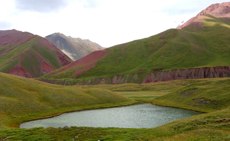
Lakes of the Pamir-Alai mountains. The largest lake in the Pamir-Alai - Karakul, in the Eastern Pamirs - lies at an altitude of 3914 meters above sea level. The basin of the lake is at the base of tectonic origin, greatly altered as a result of the impact of ancient glaciation.
Depth - up to 236 meters. Water is brackish and unsuitable for drinking. In winter, the lake freezes. The mountains rising on the sides, forming bays, islands, the blue color of water reflecting a clear cloudless sky - all this creates a picturesque landscape, especially pleasing to the eye after the lifeless gray deserts surrounding the lake.
In the south-east of Karakul Lake, in one of the basins of the Eastern Pamirs, there are relatively small lakes Shorkul (now almost divided into two separate reservoirs - western and eastern) and Rangkul, connected by a channel.
Shorkul lake is brackish, Rangkul is almost fresh. Of the flowing lakes of the Pamirs, Sarez, Yashilkul and Zorkul stand out for their size. All of them lie in modern river valleys and were formed by springing their valleys with mountain landslides or moraines.
Zorkul lies above all the large lakes of the Pamirs - at an altitude of 4126 meters above sea level. The largest of the flowing lakes of the Pamirs, which are of obstructed origin, Sarezskoye was formed in 1911, as a result of a mountain collapse damaging the Burgang-Murgab river.
The height of the obstruction blocking the valley is about 750 meters. It is called Usoi, as the village of Usoi is buried under it, the lake is named for the village of Sarez, which was flooded with water. It stands out not only for its size in plan (its length is more than 60 kilometers), but also its depth (over 500 meters), it is the next deepest lake in Central Asia after Issyk-Kul.
From the lakes of the Gissar-Alai system, one can name Iskanderkul on the northern slope of the Gissar ridge, which belongs to the basin of the Zeravshan River. This wastewater dam lake, dammed by the terminal moraine of an ancient glacier. It is famous for its exceptional picturesqueness.

Authority:
N.A. Gvozdetsky, N.I. Mikhailov. “Physical geography of the USSR. Asian part. Third edition, revised and supplemented. Moscow "Thought" 1978.
Photos by
Alexander Petrov.