


![]()
You are here
Mugalzhary Nature Reserve.
Tours of tulips of Kazakhstan.
“The child-flower opens its cup and exclaims:
"Oh dear world, do not fade, please!"
Tagore Rabindranath.
The nature of Kazakhstan.
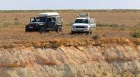
The Mugalzhary state nature reserve is located in the Mugalzharsky and Shalkarsky districts of the Aktobe region. The motivation for organizing the Bolshoi Badgers integrated nature reserve was the conservation of the azonal ecosystems of the low-mountain massif of the Mugalzhar mountains with habitats of populations of rare, endemic and relict species of flora and fauna, including the Red Book species and the extreme southern ecotope of moose.
Splitting of forests along beams and depressions is the basis for the conservation of ecosystems that are richest in the steppe and desert zones, combining zonal, azonal, and intrazonal species of plants and animals.
The Mugalzhary massif and adjacent territories have a large set of geological and paleontological monuments. Here is a key ornithological territory of international importance - a nesting and resting place for migratory birds.
The Mugalzhary Mountains are a continuation of the folded system of the Urals. Therefore, the main orographic features are predetermined by large meridional anticlinoria and synclinoria, composed of sedimentary, volcanogenic, metamorphic strata of the Proterozoic and Paleozoic, as well as up to the Paleozoic, Caledonian, and Hercynian plutons.
Mostly rocks are distributed before the Paleozoic and Paleozoic, forming large linear meridionally oriented tectonic zones. Widely developed granitoid massifs and superimposed synclinal structures formed by conglomerate-sandstones, dolomites, limestones, shales of lower and middle Carboniferous.
The marginal zones are often overlain by sandstones, sandy clay and siliceous-carbonate sediments of the Jurassic, Cretaceous, Paleogene and Neogene, with a thickness of up to 100-350 m, and river valleys are Quaternary alluvial formations.
In the superimposed troughs, relatively powerful loose deposits of the Mesozoic-Cenozoic are presented. Mugalzhary is the most elevated region of Western Kazakhstan, which is the southern end of the Urals, consisting of two meridionally elongated ridges separated by intermountain depressions.
The most elevated western part of Mugalzhar is elongated in the meridional direction and consists of many unsystematically located small hills interconnected by bridges with weakly expressed saddles. The slopes of the mountains are divided by small gullies and narrow channels.
The western slopes are steeper (up to 15 - 20 °) than the eastern (up to 10 °). The greatest height is Bolshoy Boktybai mountain (657 m) and Two brothers (634 m). Along the main ridges stretched meridionally gently sloping small ridges and ridges.
The climate is sharply continental, characterized by high summer temperatures - the average July temperature is +25 + 26 ° C and moderately cold, very little snowy winter -13 ° C. The frost-free period lasts 160 - 180 days. The average annual air temperature is + 6.9 ° C; the sum of temperatures above 10 ° C is 3200 - 3500 °.
The average annual rainfall is 200 - 220 mm, the hydrothermal coefficient is 0.5 - 0.6. The average annual wind speed is from 4 - 4.5 m / s, during the year winds of the south, southeast direction prevail. The soil cover of the northern part is represented by dark chestnut soils carbonate, phosphorite and solonetzic in combination with steppe solonetzes.
Carbonate soils are widespread and form on carbonate clays. Saline soils are usually found in combination with solonetzes. In the southern part, mountain chestnut trees are common in combination with light chestnut underdeveloped, brown desert and solonetz desert.
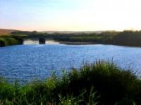
Meadow-alluvial soils are developed in damp sand basins. Salt solonchaks and takyrs are developed along the outskirts of the sand. The rivers originating in Mugalzhary belong to the basins of the Caspian and Aral Seas, and temporary watercourses to the internal drainage territories.
Here the river Zhem and its tributaries Auliye, Kundyzdy, Atzhaks originate; Ohr with a tributary of Tamda; Shuyldak, Syrlybai, Kayyndy, forming the Shet-Irgiz. The main share of river flow falls in the spring. In drying streams, ravines, water occurs only during melting snow and spring rains.
The territory is an area of formation, intense circulation and drainage of groundwater. Mostly fractured waters with a free surface are developed in the rock before the Paleozoic and Lower-Middle Paleozoic. The thickness of the fractured zone varies from 30 to 100 m.
Groundwater circulates at a depth of 30 to 50 m, in the periphery it goes to a depth of 250 to 300 m. Groundwater is generally fresh from 0.1 to 1 g / l, mainly sodium bicarbonate, less commonly calcium and magnesium.
In the weathering crust of effusive-intrusive rocks, sulfate-chloride or chloride sodium waters are formed with a mineralization of 1.5 - 3 g / l or more. Nutrition due to atmospheric precipitation infiltration. Fracture-karst, rarely fractured waters, confined to conglomerate-sandstones, limestones, dolomites of the Upper Devonian-Lower Carboniferous, are widespread in the marginal parts.
Groundwater is unloaded in river valleys, logs in the form of springs with a flow rate of 7 - 12 l / sec. Water with a mineralization of 0.8 - 1 g / l is mainly calcium carbonate or mixed. The main macrocomplexes stand out in the vegetation cover of the slopes of different exposures.
Authority:
Natural resources of Aktobe region. Ecoproject LLP. 216 p.
Photos
Alexander Petrov.