


![]()
You are here
Mugodzhary mountains.
Trip to mountains of Mugodzhary.
“Mugodzhary, obviously, are a continuation of the Guberlinsky mountains: their connection is noticeable between the Guberlinskaya fortress and Orsk, where the Ural River has dug its bed through the mentioned rocky chain and, compressed, rolls its waves between rocky and steep banks, which are the same in nature, and by outline.
These mountains in the steppe are called Tashkichu and Karaul-tepe. First, separated by the Kirgeldy, they join 30 versts from the Ural River, from where they head south in the form of an elevated plateau and then form the Urkach Mountains, or "Mountains of Ur", since the Uri River, or Or, washes their foot.
Near the sources of this river, the Urkach Mountains join with the Mugodzhar Mountains, which run to the southwest. To the west of the Urkach mountains, two chains of hills stretch: one separates the basin of the Urals and Ilek, the other - Ilek and Emba.
"Journey from Orenburg to Bukhara". E.K. Meyendofr. M. 1882. (Translated by E. K. Betger).
Traveling in Aktobe region.
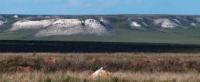
Mugodzhary Mountains are the southern continuation of the Ural Mountains, located in the northwest of the North Aral Sea, north of the Shoshkakol ridge and the Shagrai plateau, 147 kilometers southeast of the city of Aktobe, located on the territory of the Aktobe region.
Geographical position of Mugodzhar mountains.
The name of the area reflects the ethnonym: either Mongol or Mangal (Kalmyks), since in Russian sources of the 18th century they are called somewhat differently (Malgazir, Mugulzharsky, Magulzharsky). According to some scholars, this is a Kazakh word, which translates as "sharp ledges located on the peaks."
The territory of Kazakhstan includes only the southern part of the Ural Mountains - Mugodzhary. Mugodzhary are divided into two mountain ranges - western and eastern. They are a mountain range with a slope from north to south.
Near the mountains Airyk and Big Baktybai become much higher. To the south of them, they drop a little and near Zhamantau, in the upper reaches of the Atzhaksy river, they end with a sheer cliff. Farther south they become even lower and turn into hills.
They are undulating hills similar to Saryarka. Under the influence of exogenous processes, they collapsed and now they are among the low mountains. The length of the mountains from southwest to northeast reaches 200 kilometers, the width in the central part is 36 kilometers, the average height is 450 - 500 meters.
From the south, the mountains border on the northern spurs of the Shoshkakol ridge. The highest mountain of the Mugodzhar mountains is Big Bakhtybai, 657 meters above sea level. The next highest mountain is Berchogur, 638 meters above sea level, located 58 kilometers north of Big Bakhtabay Mountain.
The third highest mountain is - Two brothers 634 meters above sea level, located 22.9 kilometers northeast of Mount Berchogur. Mount Zhamantau, 561 meters above sea level, dominates in the northern part of the mountains.
In the southeast of Mugodzhar, the Big Badgers sands are located, separating them from the Aral Sea basin. Mugodzhary is crossed by a branch of the Kandyagash - Arys railway at the Emba - Shalkar (Chelkar) section. Under the influence of exogenous processes, they collapsed and now they are among the low mountains.
Relief and geological structure of Mugodzhar.
Mugodzhary in geological terms represent the southern continuation of the Ural folds. The modern relief arose as a result of a long denudation, which led to the formation of a peneplain. In this regard, Mugodzhary is an analogue of Pai-Khoi.
Against the background of the flat steppe, Mugodzhary stands out sharply, having an elevated flat wavy base. Two parallel ridges rise above the base: western and eastern. In some areas, the ridges are pointed, outcrops of crystalline rocks form rocks.
Between the ridges stretches a wide (up to 20 meters) longitudinal lowered steppe strip, interrupted by small transverse bridges. The western ridge of Mugodzhar is higher than the eastern one: in the Big Bokty-bay mountain it reaches 656 meters above sea level.
This ridge is composed of diabases and diabase porphyrites; the western slope of the eastern ridge has a similar structure; its eastern slope is composed of gabbro and diorites. The longitudinal depression between the ridges is composed mainly of Devonian sedimentary rocks.
The western slope of Mugodzhary is quite steep, and the eastern one is long, gradually turning into a plain.
Minerals of Mugodzhar mountains.
Mugodzhar mountains are rich in nickel, cobalt, chromite, copper, ferrous and rare metals. On the territory of Kempirsay, the Khromtau and Nikeltau mines were discovered. There is a coal mine near Bershugir. Marl limestone appeared at the end of the Cretaceous and is used in the production of cement.
Glass is made from the sands of the Southern Mugodzhary. In Mugodzhary, building stone is traditionally mined and crushed stone is produced (near the villages of Mugalzhar and Berchogur). In 2010, a new plant for the production of crushed stone was put into operation in the Shalkarsky district of the Aktobe region on the basis of the Berchogur-4 diabase deposit with a capacity of 700 thousand tons of crushed stone per year. Mugodzhary is a natural continuation of the Ural Mountains.
Climate of Mugodzhar mountains.
The climate is dry, similar to the climate of neighboring plains. Although the mountain systems are low, they impede the movement of air, contribute to more frequent precipitation in summer and cool the temperature in the vicinity by 1 - 2 ° C.
The average annual rainfall is 300 mm. Summer is hot, sometimes the temperature rises to +38°C. The winter is stormy, frosty, the temperature sometimes drops to -40°С. A cold wind blows from the Mugodzhar mountains, sometimes turning into a storm.
Rivers and lakes Mugodzhar.
The Or River (the left tributary of the Ural River) originates from the Mugodzhar Mountains, the Emba River and its tributaries to the west, and the Irgiz River to the east. Many of them feed on melted snow waters and therefore dry up in summer.
The aridity of the territory of the Mugodzhar mountains is affected by the insufficient amount of surface water. In Mugodzhary, a huge supply of fresh water (7,000 billion cubic meters) has been accumulated in the cracks of the earth's crust, which is used both as drinking water and for the needs of the national economy.
Flora of Mugodzhar.
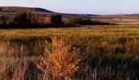
Mugodzharsky hills are covered with semi-desert vegetation with rock outcrops. Relic birch groves are located in the hollows. In the northern part of Mugodzhary, feather grass-forb steppes dominate, and in the southern part - wormwood-cereal and wormwood-saltwort steppes.
In the ravines occasionally there are groves of birch, aspen, willow, bird cherry. The slopes are covered with bushy steppes of wild cherry, bean, caragana.
Soils of Mugodzhar.
Sandy soils predominate in watersheds and depressions. There grow feather grass, wormwood. In heavily dissected depressions, there are plants belonging to the group of white and black wormwood. On the upper slopes of the ravine, bushes of acacia, meadowsweet, and wild cherries grow, and on the banks of the rivers - poplars, birches, oaks, and willows.
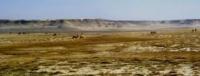
In the small hilly arid steppes of Mugodzhar, the soils are light chestnut. A vegetation cover is formed there, characteristic of the steppe and desert zones. Fescue and fluffy fescue, quinoa grow on solonchak-chestnut soils. The western part of Mugodzhary is used for crops, and the eastern part - only as pastures.
Fauna of Mugodzhar is represented by inhabitants characteristic of the steppe, semi-desert, desert zones. Saiga, elk, wild boar, hares, corsacs, wolves, foxes, ground squirrels and common hamsters live in the valleys of the steppes and mountains. Swans, geese, ducks are found in the lakes, and little bustards are found on the hills.
Geographic coordinates of Mugodzhary mountains: N49°00'47.22" E58°39'34.20"
Authority:
“Central Asia Mountains”. 2009, Almaty,Publishing house “Mektep”. Authos Aldar Gorbunov, Anna Ivachenko, Sharipa Bisarieva.
http://big-archive.ru
Photos by
Alexander Petrov.