


![]()
You are here
Natural Park Buyratau.

Tours to park Buyratau.
“Nature has taken care of everything in such a way that everywhere you find something to learn”
Leonardo da Vinci.
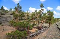
Sights of Park Buyratau.
State National Natural Park "Buiratau" (Ereymentau branch) is located on the territory of the Yereymentau district of the Akmola region and (Belodymovsky branch) on the territory of the Osakarov district of the Karaganda region.
The State National Natural Park "Buyratau" was established on March 11, 2011 by the Committee for Forestry and Hunting of the Ministry of Agriculture of the Republic of Kazakhstan as part of the implementation of the sectoral program "Zhasyl Damu for 2011 - 2014" with the support of the project of the United Nations Development Program of the Global Environment Facility (UNDP / GEF) “Conservation and sustainable management of steppe ecosystems”.
National Park "Buyratau" (translated from Kazakh - "Curly Mountains") is located in the transition zone between moderate arid and dry steppes, which determines the uniqueness of the territory in the combination of steppe ecological systems with forest (birch forests, black alder).
The territory of the national natural park belongs to the second category of specially protected natural areas with the status of a nature conservation and scientific institution of Republican significance, intended for the preservation of biological and landscape diversity, for the use of unique natural complexes and objects of the State Natural Reserve for nature conservation, ecological and educational, scientific, tourist and recreational purposes. reserve fund of special ecological, scientific, historical and cultural and recreational value.
The objects of the PA fund are: forest, geological, hydrogeological, geomorphological, zoological and botanical objects. The park "Buyratau" includes the eponymous regional natural park of local importance, the territory of the Belodymovsky and Ereimentau state nature reserves of republican importance.
The park was created on the lands of the state forest fund of Temirtau and Ereymentau forestry institutions and is located on the territory of the Ereymentau district of the Akmola region and the Osakarovsky district of the Karaganda region, consists of two branches - "Ereymentau" (60 814 hectares) and "Belodymovsky" (28 154 hectares).
The total area of the national park is 88,968 hectares. A protected area of 88,064 hectares has been created around the park. The central office is located in the village of Molodezhny, Karaganda region. The territory of the state national natural park "Buyratau" is located within the steppe zone in the transition zone between moderate arid and dry steppes.
According to the physical and geographical zoning of Kazakhstan, the territory of the state national natural park "Buyratau" is included in the Central Kazakhstan Uplands, the province of Karaganda-Chingiztau dry steppe low mountains and Uplands, the region of Ereimentau-Karkaralinsk mountain small hills, temperate, dry and dry steppe with an altitude belt.
The main types of relief of the state national natural park "Buyratau" are low mountains (hills, low mountains), high hummocks (ridge), low (hilly and hilly and ridged), as well as various types of intermountain and between the hill plains - inclined, wavy, rolling, flat.
The characteristic elements of the relief are the valleys of temporary streams, river valleys of small rivers and lake basins. The territory of the National Park "Buyratau" is located in the center of the Asian continent and therefore has a climate of a sharply continental type.
The influence of air masses from the arctic, temperate and southern latitudes determines the dryness of the spring-summer period, high summer and low winter temperatures, insufficient and unstable amount of atmospheric precipitation over the years with their summer maximum and significant wind activity throughout the year.
The sections of the state national natural park "Buyratau" are generally characterized by a large number of closed basins, mainly with salt lakes (Lake Azhbai and Bozaigyr). The depth of the lakes is not great and on average does not exceed 1 - 1.5 meters, the mineralization is significant.
The waters of the lakes are suitable only for watering animals. The main and most reliable source of water supply is groundwater, which forms artesian basins of fresh water in the Carboniferous and Mesozoic troughs, as well as fractured and stratal waters with weak mineralization, but low flow rates of sources.
Within the mountains, there is a dense network of small valleys and ravines with a temporary runoff formed during the spring snowmelt. Small rivers (the Karabulak river) carry out constant flow. At the same time, 70 - 90% of the annual runoff takes place within one and a half to two and a half weeks in the spring, after which they become extremely dry or dry out completely.
Fracture waters are widespread in quartzites. Groundwater is free-flowing and occurs at depths of 1.1 - 17 meters. At the foot of the slopes of the valleys, along the logs, there are springs with a flow rate of 0.1 to 4 liters per second.
The water quality is fresh. In general, water supply to the territory is good. In accordance with the soil-geographical zoning, the territory of the park is located within temperate dry steppes with a predominance of zonal dark chestnut soils.
It is distinguished by the originality of its constituent soil types and the complex structure of the soil cover. The rarity and uniqueness of the park's ecosystems is characterized by the following features:
the presence of relic forms,
medium degree of endemism,
combination of species representing different ecosystems of fauna and flora, their diversity.
Before the creation of the SNPP "Buyratau", on the basis of the regional natural park, also called "Buyratau", in 2001 an open-air cage was built for keeping and breeding ungulates - red deer (marals) with the aim of their further acclimatization in the wild in the region of the national park where they lived in the recent historical past.
A spacious open-air cage (400 hectares), which allows animals to eat natural food most of the year, winter feeding according to established norms and ration, proper sanitary and veterinary supervision created good conditions for the breeding herd.
The daily work of the state national natural park "Buyratau", according to the work plan approved in accordance with the established procedure, is the protection of the natural fund, carrying out a complex of biotechnical measures to increase the biological capacity of natural lands and species biodiversity, research and ecological educational activities, recreation and development of ecological tourism.
Geographical coordinates of natural park Buyratau (Ereymentau branch): N51°39'59.52" E72°43'09.40"
Geographical coordinates of natural park Buyratau (Belodymovsky branch): N51°14'31.71" E73°19'20.50"
Authority:
http://www.gnpp-buiratau.kz/ru/page/o-parke
Photos by
Alexander Petrov.