


![]()
You are here
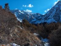
Orography of Ala-Archa park.
Walk to Ala-Archa park.
"Ala-Archa, Ala-Archa,
Water runs from the heavenly mountains.
Your beginning is Ala-Archa,
Where everlasting snow lies."
A.Yu. Prikhodko.
Nature of Ala-Archa park.
Ala-Archa gorge is located in the central, highest part, on the northern slope of the Kyrgyz Ala-Too ridge, 36 kilometers to the southwest, in the Alamudun district of the Chui region. Eternal snows stretch in this area for almost 200 kilometers, between the upper reaches of the Merke and Kindykty rivers in the west and the Shamsi pass in the east.
The Ala-Archa river basin is located on the northern slope of the Kyrgyz ridge, approximately on the meridian of the city of Bishkek. Its northern border runs along the foothills, towering over the latitudinal Chu - Talas depression.
In the south, the border runs along the watershed ridge of the Kyrgyz Ala-Too. Through it, in the upper reaches of the Ala-Archi, the pass of the same name with a height of 3916 meters above sea level leads to the Susamyr plateau.
In the east, this area is limited by the powerful Ala-Archinsky spur, and in the west by the same Djilamyshsky. Some gorges of the Ala-Archi basin are separated from each other by less high spurs extending from the two named ones.
These are the spurs of Elektro, Dzhylysh and Aksaysky. The length of the lateral boundaries of the basin, that is, the Ala-Archinsky and Dzhilamyshsky spurs, is 25-30 kilometers in a straight line. At the northern border of the region, the spurs are mountains with heights from 1600 to 1800 meters above sea level.
They have rounded tops and gentle soddy slopes. As we move to the south, the heights of the spurs increase. The ridges become steeper and rockier. The rivers cut deeper into the slopes of the ridges, dividing them into numerous massifs of various sizes and shapes.
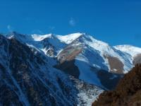
Peaked peaks appear. The high and powerful Ala-Archinsky spur is especially strongly dissected. The Ala-Archinsky spur goes north from the main Kyrgyz ridge in the Tuyuksu pass, located in the upper reaches of the glacier of the same name.
Through Taranova peak, which rises in the ridge of the spur between the Taranova pass from the south and the Altyntor pass from the north, the spur leads to the Altyn-torbashi peak. Further, it leads through the peaks of Pyatizubets and Karatash to the top of Bailan-bashi, 4700 meters above sea level, located in the upper reaches of the Topkaragai glacier near the Topkaragai pass.
The part of the spur, extending from here to the north, is the highest in the region and the most interesting in terms of mountaineering. The following peaks are located here: Two-horned, 4380 meters above sea level, Korona 4860 meters above sea level and Semenov-Tyan-Shansky peak, 4875 meters above sea level - the highest point of the entire Kyrgyz ridge.
All routes of the fifth category of difficulty are concentrated in the same place. Each of these peaks has several classified routes. You can climb Bailian-bashi by the easiest path from the southeast along the route of 2B grade of difficulty, the traverse of all the towers of this peak in both directions is assessed as 4A grade of difficulty.
If the traverse of Bailan-bashi begins with an ascent to the fifth tower along the north-western wall, then the route will be assessed as 5B. The rock route to the Two-Horned route along the southern ridge is rated as 4B grade of difficulty.
The richest in routes is the peak of Corona. On the peaks of Semyonov-Tyan-Shanskiy and Skryabin there are routes of 3A and 3B categories of difficulty, the traverse of these peaks in both directions is classified as a route of 4B category of difficulty.
To the north of the Skryabin peak, the Ala-Archinsky spur bifurcates into the Baichechekei and Uchitel spurs. Each of them has several peaks of the 1st - 2nd category of complexity. The northernmost peak of the Uchitel spur, located closest to the city of Bishkek, is the Pioneer 4050 meters above sea level with routes 1A (from the south) and 2A categories of difficulty (along the northern ridge).
From the top of Bailian-Bashi to the west and further to the north-west, the Aksai spur departs with a number of interesting and popular peaks among climbers. From the north, it is bounded by the Aksai glacier. The northern extremities of the Aksai spur extend almost to the very alpine camp "Ala-Archa".
In this spur there is Teketor peak 4441 meters above sea level, clearly visible from the camp and, as it were, closing the gorge (in fact, the Ala-Archa gorge stretches for many kilometers to the south). The most difficult peak of the Aksai spur is the Svobodnaya Korea peak, 4740 meters above sea level.
This summit breaks off to the north by impregnable, seemingly rocky walls. The easiest way to climb Svobodnaya Korea Peak runs from the southeast and is rated as a 4B route of difficulty category. Along the eastern ridge with an ascent to it along the southeastern wall, a combined route passes, which can be estimated at 5A category of difficulty, along the north-western wall - also 5A category of difficulty, and along the northern wall - 5B category of difficulty.
The groups of L.V. Dyshlyaeva, B. Studenina and V. Bezzubkia passed here routes that received gold medals at the championship of the Union in mountaineering. To the west of the Ala-Archinsky glaciers and the Ala-Archa pass, the Djilamysh spur departs from the Main Kirghiz ridge, giving two branches (the Dzhylysh and Electro spurs).
The section of the Djilamysh spur between the main ridge and the Dzhylysh spur has several peaks that are not of great technical difficulty: these are Ulartau, 4100 meters above sea level, Mindjilki-bashi, 4115 meters above sea level, Loose, 4036 meters above sea level , Ozernaya with a height of 4089 meters above sea level, Plane with a height of 4115 meters above sea level, Uzlovaya with a height of 4150 meters above sea level, from it the spur Dzhylysh departs to the east.
Bounded by the Djilamysh spur from the east and the Dzhylysh spur from the west, the circus of the Adygene glacier serves as a training ground for beginner alpinists and young dischargers. There are more
han ten peaks with routes of the 1st - 3rd category of difficulty.
For the first time, athletes who come to the mountains usually climb the peaks of Adygen, 4404 meters above sea level, and Electro, 4090 meters above sea level, along routes 1A and 1B of the category of difficulty.
These peaks, as well as Panfilova with a height of 4300 meters above sea level - 1B and 2A categories of difficulty, 30 years of the Komsomol with a height of 4250 meters above sea level - 1 and 2 categories of difficulty, Djilamish-bashi 4150 meters above sea level - 1B category of complexity, located in the Electro spur.
In the spur of Dzhylysh there are peaks: Smena with a height of 4200 meters above sea level - 2A and 2B categories of difficulty and Savator-bashi with a height of 4200 meters above sea level - 1B and 2B categories of difficulty.
Here they ascend from the circus of the Adygene glacier to the peaks of the Dzhylysh spur: Shubin peak with a height of 4200 meters above sea level - 3A category of difficulty and Kirov peak with a height of 4200 meters above sea level - 3B and 4A categories of complexity or make a traverse to the summit of the Spartakiada Games with a height of 4100 meters above sea level - 3B categories of difficulty.
The peaks of the Main Kyrgyz ridge in the upper reaches of the Ala-Archi basin, due to their remoteness from the camp, are rarely visited by climbers.
In the area between the Djilamysh and Aksai spurs, there are two more small spurs, in one there is the Manas peak 4370 meters above sea level and the Ala-Archinsky peak 4000 meters above sea level, and the other, no longer high, branches off to the north of Medic peaks 4420 meters above sea level.
The most famous peaks of this section of the main Kyrgyz ridge are: Robson Peak 4200 meters above sea level, Keldo-Choku 4050 meters above sea level, Toktogul 4460 meters above sea level, Logvinenko 4410 meters above sea level and Akduval 4410 meters above sea level.
Roka Ala-Archa, originating from the Ala-Archinsky glaciers, cuts through the territory of the region from south to north. In the upper part, the valley is a canyon, the width of which ranges from one to three kilometers at the top, and 50 -100 meters along the bottom.
The height of the slopes above the bottom here is from 400 to 800 meters. In the middle belt, the valley expands to 200 - 300 meters, and the height of the slopes decreases to 300 - 600 meters. In the foothills, the valley is up to 1.5 kilometers wide.
The large dissection of the basin and significant differences in altitude (on average, 1 kilometer of distance increases by 131 meters) determine here a great variety of natural conditions.
Geographic coordinates of the Ala-Archa gorge: N42 ° 33'50.69 "E74 ° 28'48.58"


Authority:
A. Kuznetsov "Alaarcha". “Defeated peaks. 1973 - 1974 ". “Mysl”. Publishing House, 1976.
Photos by
Alexander Petrov.