


![]()
You are here
Orography and geology of Korgalzhyn reserve.
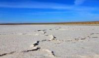
Photo tours of lakes of Korgalzhyn reserve.
“To protect nature means to protect the homeland”
Prishvin M.M.
Photos of Korgalzhyn reserve.
The reserve is located in the dry-steppe zone of Kazakhstan. Characteristic zonal dry-steppe landscape in combination with the water areas of lakes. The relief in the area of the reserve represented by a weakly dissected lake alluvial plain.
On the lands adjacent to the reserve the plain is significantly dissected by small ravines, gullies and small rivers. Absolute heights range from 304 to 318 meters above sea level. The general slope of the surface is directed to Lake Tengiz, itself large reservoir of Central Kazakhstan.
On the territory of the reserve, relief forms are distinguished:
lake alluvial plain Korgalzhyn reserve,
lake hollow Korgalzhyn reserve,
lake delta plain of the Nura River Korgalzhyn reserve,
delta plain Kulanotpes River Korgalzhyn reserve.
From the position of orography, the reserve is located in the western part of Central Kazakhstan small hills (CCM), which is a system of low island mountains and hills. By the researchers of the Central Concern Center (Svarichevskaya, 1961; Malinovsky, 1967) the plain and thick weathering crust that formed on the territory of the MSC in the Mesozoic had a large importance for the development of the relief in the subsequent time.
Throughout the Cenozoic in the reserve area plains of different genesis have repeatedly succeeded each other (Malinovsky, 1967). Modern look territory began to take shape in the upper Pleistocene. Intensive diving around Lake Tengiz formed the Tengiz-Korgalzhyn depression, changed the flow of rivers.
The formation has begun The lacustrine alluvial plains that continues to the present. Geologically, the reserve is located in the southern part of the Tengiz depression. The vast intermountain basin, inheriting the ancient structural plan of the Caledonian period, is formed by the Hercynian structures (Clubs, 1956).
There are no Mesozoic deposits in the basin (Mazarovich, 1958). Tertiary sediments as cover formations occur on Paleozoic rocks. South of Tengiz Lake Paleozoic rocks come to the surface and can be traced in large spaces its bottom (Volkov, 1960).
Low-power tertiary deposits are represented by gray-green clays. Aral Formation and overlain with lumpy clays of red-brown color Pavlodar Formation. Deposits Quaternary periods are represented by loesslike loams and lacustrine alluvial deposits.
They are parent rocks and largely determine the modern nature of the territory. Fossil forms of animals and plants of carbon age are known in the space between the lakes Kerey and Kiyakty 9 to 10 kilometers south of the borders of the reserve (Bykov and Arystangaliev, 1987).
Authority:
"Korgalzhyn State Nature Reserve." Sidorova T.
Photos by:
Alexander Petrov.