


![]()
You are here
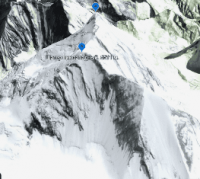
Peak Shater Zapadnyi.
Mountaineering expeditions in Kazakhstan.
“There are no such mountains either in Russia or in the whole of Europe. The Aleksandrovsky Ridge is higher than the Alps and higher than the Caucasus ... And the highest point of the Mont Blanc Alps (14,754 feet) is even lower..."
Military doctor Ivan Ivanovich Zarubin, one of the first mountain climbers of the Tien Shan. 1879
Mountain routes in mountains of Kazakhstan.
The snow-ice summit Shater Zapadny is located at an altitude of 6511 meters above sea level, located in the easternmost part of the Tengri Tau ridge in the Narynkol district of the Almaty region. In the main ridge of the Tengri Tau ridge, at a distance of 5 kilometers to the east and a little to the north, there is a summit under the general name of Shatry.
In turn, the peak loses its individuality and is divided into two independent peaks - the Zapadnyi and Vostochnyi Shater. Shater Zapadny is closest to the dominant peak in the ridge - Khan-Tengri peak, which is 4.5 kilometers away (in a straight line) to the south and slightly to the south.
The distance from the top of the Zapadnyi Shater to the top of the Vostochnyi Shater is 1.8 kilometers. From the summit with steep avalanche-prone slopes in the shape of a tent, an almost vertical rock wall breaks off to the west, ending at an altitude of 5692 meters above sea level on the Razorvanny glacier, which is located under the eastern slopes of Khan-Tengri peak.
In the lower part, the glacier is the right tributary of the Demchenko glacier. From the top of Shater Zapadny, a ridge departs to the southeast, which, after 1.2 kilometers, ends with the summit of Saladin (it is also the summit of L.A. Gutman) with a height of 6201 meters above sea level.
From the summit to the southeast flows the sources of the Demnchenko glacier, which at an altitude of 4399 meters above sea level merges with the South Inylchek glacier, the sources of which are located on the northern slopes of the Voennyi topografov peak.
The classical route of the summit is rated 5B by the category of difficulty. The state border between the Republic of Kazakhstan and the Republic of China passes through the top from north-east to east. From the northern slopes of the peak located in Kazakhstan, the headwaters of the Northern Inylchek glacier with a length of 42 kilometers and 11 kilometers across the territory of Kazakhstan begin.
First ascent to Shater peak.
In 1968, the first ascent to Shater Peak was made by a Kazakh team led by G. Kireev.
In 1968, the first traverse of the Shaters peaks - Khan-Tengri - was completed. This traverse of the 6th category of difficulty, made by the team of the CS DSO Spartak under the leadership of B.A.Studenin (coach) as part of the team: A. Afanasyeva, V. Zapeki, V. Popov, V. Tokmakov, E. Ilyinsky, E. Kambarov, A. Toporkova. The teams took first place and gold medals in the class of traverses in the Championship of the Soviet Union.
Geographic coordinates of the Zapadnyi Shater peak: N42 ° 13'01.27 "E80 ° 13'34.83"
Authority and photos by
Alexander Petrov.