


![]()
You are here
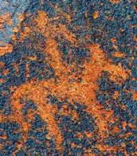
Petroglyphs Khantau mountains.
Group Tours in Kazakhstan.
“Who creates destiny - gods or people? Can one person affect the balance of power in the world? What is hidden behind the prescription of times? Our time, the nomadic steppes of Central Asia since the first millennium BC, the mysterious Tibet, the ancient Bon religion and the gods of nomadic Turks, people of all times, their lives, their feelings, their actions, their beliefs and the importance of every life for people and gods. Verily, the path of the spirit must be passed by the feet of men.”
Nicholas Roerich.
Luxury individual tours in Kazakhstan.
The Hantau Mountains stretch from northwest to southeast for 43 kilometers. The northwestern border of the Khantau mountains is the Shantas mountains, the southeastern border is the drying out bed of the Aksai stream.
The dominant mark of the Hantau Mountains is an unnamed peak 1104.2 meters above sea level. In the west, the mountains border the valley of the Shu River and the Sekseul-Dala steppe; in the north, the small mountains Kuyeli-Karatau and the Zhusan-Dala steppe are the border of the mountains.
The Khantau mountains are located in the Moyinkum district of the Zhambyl region. The Khantau mountains are composed of granites, shales, limestones; they are a large massif, composed mainly of granites and effusive rocks.
The geographical location of this mountainous region, surrounded from the west, north and east with the Moyinkum, Betpak-Dala and Taukum deserts, predetermined its special significance in the system of interregional communications, cultural, economic, political ties and relations, which remained for it over the last three millennia of Central Asian history.
At different historical times, on the border of rugged deserts, paths converged here, connecting the peoples and states of Eastern Europe and Western Siberia, Central Asia, the Inner Tien Shan and China. Until the middle of the XIXth century.
In the mountain valleys of Khantau, trade caravans with exotic goods from Bukhara and Tashkent stopped for rest before continuing on their way across the desert to the shores of Balkhash and further to the Irtysh and Tobol.
From here to the Volga through the Kazakh steppe led in the 17th - mid-18th centuries the main strategic highway - Bolshaya Kalmyk the road connecting the nomadic headquarters (urgu) of the Dzungar khans and Tibet with the Volga Kalmyks.
Here, to the foothills of Hantau, Major K. Miller arrived in the winter of 1742, sent to the headquarters Galdan-Tseren with a diplomatic mission - to free the Russian citizen Sultan Abylai from the Dzungarian captivity.
So the Russian envoys became the first Europeans who reached the Chu-Ili mountains by the shortest steppe route, which caused surprise and concern for the Dzungars, who cruelly massacred with a brave expedition guide.
Decades later, when the Dzungar Khanate collapsed under the blows of the Chinese troops, from the Syr Darya steppes to the northern spurs of the Chu-Ili mountains, according to legend, Binazar-batyr brought his relatives-dulats, who received the honorary title not only for military services, but also for what he saved his people in difficult years by teaching arable farming and crafts in the Chu river valley. The mausoleum of Binazar Akediluly was erected today at the foot of Mount Sunkar at the sources of the bitter salt source.
The archaeological monuments of Khantau, which, unfortunately, are still fragmentarily studied, give an idea of the most ancient stages in the history of the region. The discovery of many of them is associated with the names of geologists A. G. Medoev, V. I. Volobuev, historians and ethnographers S. Zholdasbaev, K. Baibosynov; only at the Kozhabala burial ground were excavations carried out by the archaeologist RB Ismagilov.
The most studied type of monuments are still rock carvings. The largest accumulations of petroglyphs - Sunkarsai, Ulkentaldy, Sholakzhideli and Terekty, starting with wide drainage funnels, form deep and narrow gorges in their mouths, which served as an ideal environment for organizing galleries of rock paintings.
As a rule, in the upper part of the valleys, at the sources of small rivers and springs, there are sites of the Neolithic period and later eras, including the Middle Ages; Frequent finds of ornamented easel utensils indicate the close ties of nomads with the settled settlements and cities of the Chui Valley.
In the foothill zone there are small groups of mounds of early and medieval nomads, but the largest necropolises are concentrated at the southern foothills of Mount Sunkar. Along the chains of mounds, groups of memorial fences are lined up, made of seven to eight large stones.
In appearance, these burial mounds with fences resemble the monuments of Gorny Altai belonging to the Pazyryk culture of the Scythian time. Ritual stone enclosures and sculptures of the Turkic period are often found on elevated intermontane areas, but in most cases these monuments have traces of later destruction.
The oldest explored monument in Khantau is the Kozhabala burial ground on the northeastern slope of Mount Sunkar. There are about 150 burial structures here, represented by stone boxes in rectangular or rounded fences; In the excavated graves, the remains of cremation and corpses were discovered, accompanied by ornamented dishes and bronze ornaments (bracelets, pendants, beads).
By the nature of these finds, the burial ground dates back to the 13th century. BC e. and belongs to the type of monuments of the Andronov cultural and historical community, common in the southern part of Saryarka and Western Semirechye. Like some other burial grounds of the Bronze Age of the Chu-Ili Mountains (Tamgaly I, Oi-Jailau III), the Kozhabala necropolis records the path of advancement in the last third of the IInd millennium BC. e. steppe tribes of Central Kazakhstan to the foothills of the Tien Shan.
The oldest petroglyphs in the mountain valleys of Hantau also date from the Bronze Age. At the same time, among them there are engravings, in terms of content and style, are more characteristic of the monuments of rock art in the Northern Balkhash region.
However, the most striking petroglyphs of Hantau are represented by the works of artists of the middle of the 1st millennium BC. e., many of which are unique or are among the rare specimens of rock art from the era of early nomads, specific to the Chu-Ili mountains.
Noting this artistic feature of the rock engravings of the Khantau mountains, A.G. Medoev wrote that “Great nomad camps gave great art”. The rocks of a small rocky canyon at the mouth of the Sholakzhideli valley are distinguished by the abundance of petroglyphs of the Saka period.
Most of the engravings focus on the right side of the canyon; the left slope, unfortunately, is badly destroyed: in previous years, building stone was mined here. The rock massif is formed by alternating rows of erosional terraces in the form of high steps, which makes the entire canyon resemble the hall of an ancient theater.
All rocks are covered with "desert tanned ”, but the best qualities for pictorial activity were apparently possessed by the horizontal surfaces of the terraces, on which the overwhelming majority of petroglyphs were carved.
Therefore, it is possible to see the rock paintings only while climbing the slope or standing at the edge of the ledge. This feature of the Sholakzhideli rock gallery distinguishes it from all other famous monuments of Khantau and Chu-Ili mountains.
On the rocks of the canyon there are petroglyphs of the Bronze Age and the Early Iron Age, and the most ancient drawings occupy only a few wide planes; the rest of the surfaces were used by artists of the Saka era.
There are few medieval petroglyphs and renewals of ancient drawings, so most of the early engravings are well preserved. In total, there are about 1000 petroglyphs here. Compositions with images of horses, bulls, camels and chariots belong to the Bronze Age; a two-wheeled carriage is shown schematically, without draft animals.
In terms of stylistic features, they differ slightly and, apparently, were created during the same period. Among them there are several skilfully executed drawings, but thematically the compositions of this time are rather monotonous.
The scene of the confrontation between two rearing stallions, located on the upper tier of rocks of the canyon. Petroglyphs of the Saka time are often engraved on the same planes and in some cases overlap the drawings of the Bronze Age.
But on the whole, this stratum of petroglyphs is heterogeneous, and, in turn, early and late series of images are distinguished here, which also overlap each other in many compositions. Engravings of the Saka time are presented mainly on the peripheral rocks of the canyon and are characterized by a peculiar manner of depicting wild animals - herbivores and predators.
However, the main background of the gallery is created by petroglyphs of a different pictorial tradition, in which some features of the animal style are still preserved, but the plasticity of the drawing inherent in Saka art is lost, and decorative elements noticeably prevail.
A series of contour images of animals, the body of which is filled with all kinds of lines, volutes and other ornamental figures, dominates the main panels of the canyon. Openwork figures of animals here roughly overlap engravings by artists of the Bronze Age and the Saka period, claiming by their presence a change in artistic traditions and, possibly, ethnocultural environment in the second half of the Ist millennium BC. e.
Among them, a unique depiction of a deer with tree-like antlers stands out, on the back of which figures resembling wings are shown. In general, this series of petroglyphs finds analogies far in the northeast, in the art of the Tagar tribes of the Middle Yenisei and the Pazyryk culture Altai, as well as among the rock paintings of some other monuments of the Chu-Ili mountains (Anyrakai, Tamgaly) and in the Issyk-Kul region (Cholpon-Ata).
At the same time, the Sholakzhideli petroglyphs are the largest in the Chu-Ili mountains a series of drawings of this type and differ in some originality. Another rare category of engravings from the Early Iron Age is represented by images of mirrors.
Petroglyph mirrors have now been found at several points scattered throughout the Chu-Ili Mountains from Kulzhabasy in the south to Khantau in the north. In Sholakzhideli on five mirrors with a straight protruding handle are depicted on one plane next to the "winged" deer; four of them are carefully executed, respecting the proportions, shape and, apparently, the size of real objects.
Comparison of images with dated artifacts makes it possible not only to establish the probable age of petroglyphs, but also to consider them as indicators of historical and cultural contacts of the early nomads of Semirechye with the tribes of remote regions of ancient Central Asia.
It is noteworthy that in other territories of the Semirechye, for example, in the Dzhungar Alatau, where a huge number of petroglyphs of the Saka time are known, images of mirrors are not found. At the same time, single rock carvings of mirrors with a protruding handle are fixed at the monuments of Gorny Altai (Kalbak-Tash).
Thus, petroglyph mirrors, along with other finds and monuments of the Chu-Ili Mountains, reflect the special historical significance of this geographical region in the system of rock art in Kazakhstan.
Geographic coordinates of the Hantau mountains: N44 ° 13'36.64 "E73 ° 55'05.03"
Authority:
"From Altai to the Caspian Sea". Atlas of monuments and sights of nature, history and culture of Kazakhstan. 2012.
http://lib.yessenovfoundation.org/atlas-tom-2/files/assets/basic-html/page330.html
Photo by
Alexander Petrov.