


![]()
You are here
Petroglyphs of Zaraut-Kamar.
Travels in the Surkhandarya region.
“The greatest misunderstanding is to go into morality when it comes to historical facts”
Didro D.
Excursion to the petroglyphs of Zaraut-Kamar.
Grotto is in the Zaraut-Say Gorge on the southeast slope of the Kugitangtau Mountains within the system of the southwestern spurs of the Hissar Range. Administratively, Zaraut-Say belongs to the State Nature Reserve “Surkhan” in the Sherabad District of the Surkhandarya region, 30km north-west of Sherabad city, 5km south of the Kyzylolma settlement.
The absolute height is 1,265 meters above sea level. Research Status. The Russian military topographer Fyodorov was the first to survey and copy (sketch from nature) images and inscriptions in Zaraut-Kamara, in 1912.
Later, in 1939, the gorge was visited by I.F. Lomaev who heard from local residents about a cave with drawings, examined them and made sketches and informed G.V. Parfyonov, an archeologist and regional ethnographer and the Director of the Surkhandarya Museum in Termez. G.V. Parfyonov conducted scientific research and documentation of the site in 1940 and 1943 - 1945.
In particular, he explored the Zaraut-Say Gorge and adjacent valleys in addition to identifying and copying images. Parfyonov made small test excavations in some other caves: in the Dul-Dul-Ota grotto he found Mousterian stone flakes and painted ceramics near the Chinar settlement, but no more rock art.
Parfyonov used this circumstantial evidence and analysis of the images to suggest that the Zaraut-Kamara paintings dated to the Upper Paleolithic. Arabic inscriptions painted on the cave walls with a bright-red pigment were dated by M.E. Masson to the Xth - XIIIth centuries. An artist, A.Yu. Roginskaya, who participated in the expedition led by Parfenov, made pencil and watercolor sketches of the landscape and the cave paintings, under the guidance of Parfenov.
Roginskaya recorded 264 painted images in the central cave and 27 in other nearby caves and niches. A subsequent inspection of the site by A.A. Formozov in 1964 revealed that a significant proportion of the paintings indicated by Parfenov could not be found: sometimes only very indistinct traces of paint remained while natural spots of red ferrugination had been mistaken for images.
Formozov took samples of minerals similar in color to the ancient drawings from near a cave at the mouth of the Zaraut-Say and examined them in the Laboratory of the Institute of Geological Sciences of the Academy of Sciences of the USSR in Moscow.
The paint consists of quartziferous siltstone and a ferruginous cement; the iron content is high: 24 - 32 %. Formozov’s impressions at examining the site, analyzing the motifs, style, arrangement of the drawings and other data enabled him to conclude that “a Paleolithic date for the Zaraut-Kamara drawings is ruled out, a Mesolithic age is likely, but dating to later periods (Neolithic-Eneolithic) is also possible” (Formozov 1966:24).
In the 1970 - 1980’s, Zaraut-Say was researched by Uzbek archaeologists Zh. Kabirov and M. Khujanazarov. They noted that modern visitors’ inscriptions had been scratched over ancient images and inscriptions.
The most recent survey and documentation (photographs, copies and descriptions of images and inscriptions) was carried out by Khujanazarov (2001:91 - 93). Khujanazarov only identified 8 caves and not 27 (as G.V. Parfyonov had said), with a total of 40 images (more than 200 according to Parfenov).
As previously done by Formozov, Khujanazarov identified three groups of images in Zaraut-Say that differ in color, repertoire and style, and dated them to the Mesolithic and the Bronze Age. The sketches of Zaraut-Say by A.Yu. Roginskaya, published in 1950, are still the main documentation for the site.
Her drawings, repeatedly reproduced in subsequent scientific, and popular publications and textbooks, have many errors both in the reproduction of the cave’s interior on the whole, the arrangement of paintings, and the reproduction of many images; also, medieval inscriptions are not reproduced in Roginskaya’s drawings.
The copies of drawings from ZarautKamara published by A. Rozwadowski may also be inaccurate (Rozwadowski 2004, Fig.5). Description of the Site. The Zaraut-Kamar Grotto is on the right slope of the Zaraut-Say Gorge at the mouth of a rocky canyon between high mountains and low hills.
The Zarait-Say Valley expands below the canyon, stretches for 2 - 3 km from north to south along fine sandstone foothills then turns westward. This part of the valley has a prominent ancient terrace, with remnants of stone structures and ceramics (including medieval ones) in a series of sites.
Remnants of stone structures and kurgans were also recorded on the ridges of long flat-topped uplands that form watersheds in the Zaraut-Say and neighboring valleys. The rocky slope of the canyon, where Zaraut-Kamara Grotto is located, appears as a bench composed of alternating layers of limestone of the Middle Jurassic Period deposited at an angle of 45-50° stretching northward.
The bench has a layered structure and pronounced profile. The surface of near vertical rocks is strongly wind-eroded with numerous niches and caves of various sizes. The main one – Zaraut-Kamara – is located in the middle of the rock massif at a height of 8m above the valley surface.
There is a series of caves with solitary images and Arabic inscriptions in the lower part of the rock. According to A.A. Formozov, the main cave is 1.4 - 2.5m wide, 5.2m long, and 3.97m high; it opens to the east.
There are no deposits or cultural remains in the cave; but in the northern part, i.e., directly under the roof, a concentration of ancient drawings and a small polished 5cm-deep indentation stand out against the black surface of the floor.
The cave roof and walls are covered with a light-brown and pinkish carbonate coating. The lower part of the walls and the floor of the grotto are free from sinter, while the surface is black or dark-gray, uneven and polished in some places.
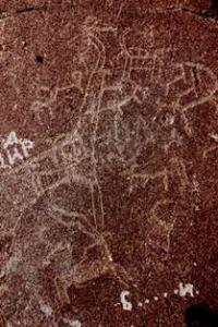
In some places on the walls and the roof, calc-sinter sometimes overlies ancient images and medieval inscriptions. Modern graffiti have been scratched in the lower parts of the walls. Ancient images on the western and northern parts of the walls constitute three major panels, with animals, anthropomorphs and bird-human figures and unidentified signs painted in a red-brown and gray-brown mineral paint.
When the images are moistened their color changes to maroon.
Medieval inscriptions are painted in a bright red pigment on an unoccupied area of the roof and walls. Arabic inscriptions partly overlap a few ancient figures which only mainly occupy good-quality surfaces between the ancient panels.
A panel featuring a relatively large figure of an ox stricken with an arrow, archers and bird-human figures, stands out among ancient images on the northern wall. According to the researchers of Zaraut-Say, the bird-humans represent hunters disguised as birds (great bustard, ostrich) or dressed in loose cloaks.
The other two panels also represent scenes of wild animalhunts (cattle, gazelle (?), and others). Most of the 40 images are outlined, relatively small (5 - 7cm; the largest figure of an ox is about 15cm) and artfully carved.
Below the main grotto, drawings in several niches are smaller in size. The images are also painted in a red-brown pigment, but they are brighter and differ in style from the drawings in the main cave andseem to date to a later period.
Due to the remoteness of large residential settlements and as part of the Surkhandarya Reserve, the Zaraut-Say landscape is in a good condition. Roads that allow car access to the Zaraut-Kamar grotto are practically non-existent.
Usually, visitors – local residents and tourists – get by car to the nearest settlements and then either go on foot or hire donkeys to go further. Considering the fame of the site, these two prevailing circumstances are factors that curtail excessive human impact.
Nevertheless, uncontrolled visitation of the site has affected the interior of the Zaraut-Kamar cave, with many graffiti on the walls: names and dates of visits (the latest date is 2004). Most are either scratched or pecked onto black wall surfaces without rock art, but some inscriptions are carved on the cave roof which has ancient images.
Some images are damaged from natural causes: in some places, carbonate sinters that have formed as a result of rain infiltrating through cracks in the roof overlay images and medieval inscriptions. Protection and Management.
The Zaraut-Kamar Grotto is located on the territory of the regional state natural reserve “Surkhan” founded in 1986. The Central Office of the Reserve is located in the district capital, Sherabad. The Northwestern boundaries of the reserve along the watershed of the Kugintang Mountains coincide with the national border between Uzbekistan and Turkmenistan.
The total area of the reserve is 25,853 ha. The government has acquired this specially-protected area but no protection has been established. The grotto and the middle of Zaraut-Say are close to the protected and buffer zone of the reserve which encompasses about 10 settlements with a total population of 4,000 residents.
People from nearby settlements, Kyzylolma and Khodzhaankan (both 5km south and north of the site), pasture their livestock in Zaraut-Say and illegally cut brushwood (archa) as firewood. In spring they visit the valley and grotto where the rock art is and act as guides for tourists.
Authority:
Muhiddin Khujanazarov.
Photos by
Alexander Petrov.