


![]()
You are here
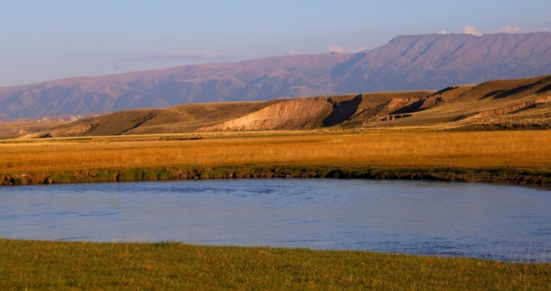
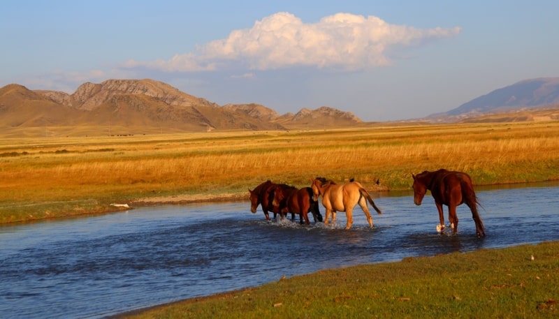
River Karkara. General description.

Guided walking tour Astana and Almaty.
“Nature encourages no looseness, pardons no errors”
Ralph Waldo Emerson.
Special excursion in Turkestan.
The border river Karkara is located on the northern slope, in the eastern part of the Terskey Alatau ridge, flows through the territory of the Tyup region in the east of the Issyk-Kul region in Kyrgyzstan and through the territory of the Raimbek and Kegen regions of the Almaty region.
Vasily Vasilyevich Radlov, a Russian orientalist-Turkologist, ethnographer, archaeologist and teacher of German origin, one of the pioneers of the comparative historical study of Turkic languages and peoples, interpreted the origin of the name of the area and the Karkarae River as follows:
“The name of the area and the river is that because a bird lives here, which is called karkara. "Karkara" is a kind of heron, and also some girls cling to the feathers of this bird on their headdresses, which are also called "karkara" (1893, v.1 p.190).
The ethnographer and researcher of folklore, traditions and customs M. Krasovsky wrote the following in his geographical and statistical notes about the Kazakh steppe: they call the chests "karkara". And since the trunks and the outlines of some mountains are similar, then the mountains are called Karkara. " (Krasovsky M., 1988, part 1, p. 108 - 109).
Approximately, the ethnographer Shokan Valikhanov was of the same opinion. "Karkara - the Kazakhs call the feathers, the sultan on the head of two young Kalmyk girls captured by the river." (Valikhanov Ch., 1984, p.).
The Karkara River is formed from the confluence of the two rivers Kokzhar and Turuk. The eastern tributary of the Kokzhar begins from the northern slopes of the Terskey Alatau ridge on the territory of the Raimbek district of the Almaty region.
The western tributary of the Turuk also begins from the northern slopes of the Terskey Ala-Too ridge in the Tyup district of the Issyk-Kul region. The area of the river basin is 1970 square kilometers, the average annual discharge of water at the mouth is 11.3 cubic meters per second.
In the vicinity of the Kyzylmoynok pass with a height of 2801 meters above sea level, first along the Kokzhar River, and then 6.7 kilometers later along the Karkara River, the state border between the Republic of Kazakhstan and the Kyrgyz Republic begins.
On the territory of the Kyrgyz Republic, Karkara flows 32 kilometers from the confluence of the Kokzhar and Turuk rivers. The left bank of the river with tributaries is located on the territory of the Kyrgyz Republic.
Karkara is a left tributary of the Kegen River on the territory of Kazakhstan in the vicinity of the Shyrganak (Karkara) village, the mouth is located at an altitude of 1,777.8 meters above sea level. After flowing into Kegen, the river loses its name.
Northwest of the village of Karkara, the Karkara River acquires a flat character and is divided into numerous channels and oxbows. To the north of the village of Buleksaz, in the valley of the same name at an altitude of 1821 meters above sea level, the right channel of the Keshi-Karkara separates from the main channel of the river and at an altitude of 1786 meters above sea level it flows into the Kegen River on the left.
After the Karkara River leaves the mountains, it spreads over the swampy foothill plain, forming meanders that stretch far beyond the Kegen village to the east. It is necessary to pay attention to the repeated names of rivers on Soviet topographic maps, which are present 12.5 kilometers before the exit of Karkara to the foothill plain.
Unfortunately, I did not find official corrections or explanations to the double names of these rivers. We are talking about two times, repeating names, of the Uchkashka rivers, which are the left tributaries of the Karkara River in the territory of the Kyrgyz Republic and their right tributaries with the same names Kechine-Uchkashka.
In accordance with the cardinal points, I named them Uchkashka Zapadnaya and Uchkashka Vostochnaya, respectively, Kechin-Uchkashka Zapadnaya and Kechine-Uchkashka Vostochnaya, to avoid misunderstandings.
The very first sources of the Karkara River begin from the Dzhak River located on the territory of the Republic of Kazakhstan.
Geographic coordinates of the Karkara River: N42 ° 51'19.35 "E79 ° 14'19.66"
Jak River.
The southern tributary of the Kokzhar River is the Dzhak River, 14 kilometers long, which originates from the northwestern slope of the Kashkator Pass 3609 meters above sea level. The river receives three tributaries on the right.
The first tributary, 3 kilometers long, the river receives from a swampy lake located at an altitude of 3913 meters above sea level. The second tributary Kokpak, 2.5 kilometers long, the river receives through 130 meters. The stream flows down from the western slope of the Kokpak pass 3482 meters above sea level.
The third unnamed tributary, 4.3 kilometers long, is received by the river 900 meters after the confluence of the Kokpak brook. The tributary originates from the southern side of the unnamed pass 3472 meters above sea level and flows into the Jak at the site of a large camp of local shepherds and shepherds.
Geographic coordinates of the Kokpak River: N42 ° 28'40.51 "E79 ° 40'39.91"
Geographic coordinates of the Jac River: N42 ° 27'01.16 "E79 ° 39'48.71"
Kokzhar river.
The length of the Kokzhar River is 35 kilometers. The main channel of the river is formed at an altitude of 3009 meters above sea level by the Jak River, which largely fills the river. Passing a height of 3009 meters above sea level, the Dzhak river loses its name, and the river waters get a new name - Kokzhar.
Along its course until the confluence with the Turuk River, Kokzhar will receive 28 tributaries on the right, most of them small and only some significant. After 1 kilometer of its course, the Kokzhar River passes through a small reservoir with a dam located at an altitude of 3014 meters above sea level.
An unnamed 3.2 km long tributary flows into the reservoir on the right. The source of the stream is located at an altitude of 3691 meters above sea level. After 4 kilometers, Kokzhar receives an insignificant tributary-stream on the right. The speed of the river after the confluence of the right tributary of the Kubergena reaches 1.5 kilometers per second.
Geographic coordinates of the Kokzhar River: N42 ° 33'35.92 "E79 ° 25'01.96"
Right tributaries of the Kokzhar River.
River Kubergeny.
Soon, 7 kilometers after the reservoir, the river receives on the right a 4.5-kilometer long tributary of Kubergena. The river originates from the western slope of the Kubergenti pass, 3570 meters above sea level. The mouth of the river is at an altitude of 2904 meters above sea level.
Geographic coordinates of the Kubergenta River: N42 ° 31'04.62 "E79 ° 36'52.38"
Tuz River.
8 kilometers after the Kubergenti tributary, the Tuz River flows into the river on the right at an altitude of 2799 meters above sea level. The Tuz River is 12 kilometers long. One of the tributaries of the Tuz originates from the north-western side of the Tuz pass, 3656 meters above sea level.
The Tuz pass is a watershed between the sources of the Tekes and Tuz rivers. The right tributary begins from the southwestern side of the Kindyktobe pass, 3627 meters above sea level. One of the sources of the Tekes River begins on the eastern side of the pass.
Starting from the source, the river receives 6 small tributaries on the right. The longest is the last tributary in front of the mouth of the river to Kokzhar with a length of 5 kilometers originating from the southeastern side of an unnamed pass 3628 meters above sea level. On the left, the river receives two tributaries, streams.
Geographic coordinates of the Tuz River: N42 ° 33'42.63 "E79 ° 32'24.38"
Beytybulak river.
3.5 kilometers after the Tuz River, the 5.4 kilometers long Beytybulak River flows into Kokzhar on the right. The river originates from an altitude of 2902 meters above sea level. The estuary is located at an altitude of 2768 meters above sea level.
Geographic coordinates of the Beytybulak river: N42 ° 33'18.77 "E79 ° 28'26.73"
On the right bank, between the mouths of the Tuz and Beytybulak rivers, two tributaries flow into the Kokzhar.
Zharbulak river.
2.5 kilometers after the confluence of the Beitybulak, the Zharbulak flows on the right with a length of 3.6 kilometers. The sources of Zharbulak lie at an altitude of 3286 meters above sea level, the mouth of the river is at an altitude of 2739 meters above sea level.
Geographic coordinates of the Zharbulak river: N42 ° 33'44.03 "E79 ° 27'19.06"
Between the mouths of the Zharbulak and Beytybulak rivers, Kokzhar receives three tributaries on the right.
Tiek river.
4.2 kilometers after Zharbulak, the Tiek River, 8 kilometers long, flows into Kokzhar. The sources of the river begin from the southwestern slope of the pass of the same name, 3427 meters above sea level. The mouth of the river is located at an altitude of 2702 meters above sea level. The Tiek River at the mouth has a cone of stone and clay up to 500 meters.
The geographical coordinates of the Tiek River: N42 ° 35'00.78 "E79 ° 25'28.02"
Shokmortash river.
9 kilometers after the confluence of the Tiek River, the 5.4 kilometers long Shokmortash River flows into Kokzhar. The sources of the river are located at an altitude of 3794 meters above sea level. The mouth of the river is located at an altitude of 2668 meters above sea level.
Geographic coordinates of the Shokmortash River: N42 ° 35'52.81 "E79 ° 23'20.54"
Kyzyltor river.
4.5 kilometers after the confluence of Shokmortash into Kokzhar, the Kyzyltor River with a length of 6.2 kilometers flows into the right. The sources of Kyzyltor begin in the Oklytas Tau mountains in the east from the dominant height of 4019.5 meters above sea level.
The river has three right tributaries originating in the highest part of the Oklitas tau mountains. On the left, the Kyzyltor receives two tributaries, one of which is 5.2 kilometers long and both of them originate in the Tiek Mountains from the southwestern slopes of the peak 4111 meters above sea level. The mouth of the Kyzyltor is located at an altitude of 2578 meters above sea level.
Geographic coordinates of the Kyzyltor River: N42 ° 37'46.41 "E79 ° 20'53.19"
Three tributaries flow into Kokzhar on the right between the Shomortash and Kyzyltor rivers. The first two are insignificant, the third tributary, 6 kilometers long, originates from the northern slope of an unnamed peak 3794 meters above sea level.
1.3 kilometers after the confluence of the Kyzyltor with the Kokzhar, in turn, the Kokzhar receives a tributary of the Turuk on the left, hence the river gets a new name - Karkara.
Left tributaries of the Kokzhar River.
Ayusai River.
5 kilometers after the confluence of the Kubergenti River into the Kokzhar River, the 8.3 km long Ayusai tributary flows into the left. The main channel of Ayusai is formed at an altitude of 3006 meters above sea level from two tributaries.
The right tributary of the Ayusai begins from a swampy lake at an altitude of 3488 meters above sea level, northwest of the Ayusai peak, 3957.4 meters above sea level. The left tributary also originates from the northern slopes of the Terskey Alatau ridge. The mouth of the river is located at an altitude of 2834 meters above sea level. The Ayusai River is located on the territory of the Kyrgyz Republic.
Geographic coordinates of the Ayusai River: N42 ° 30'32.29 "E79 ° 32'15.80"
Zholdysai River.
After the confluence of the Ayusai River, a tributary of the Zholdysai with a length of 9.4 kilometers flows into the left through 2.7 kilometers. Zholdysai originates on the northern slopes of the Terskey Ala-Too ridge at an altitude of 3487 meters above sea level.
The mouth of the river is located at an altitude of 2799 meters above sea level. The Zholdysai River is located on the territory of the Kyrgyz Republic.
Geographic coordinates of the Zholdysai River: N42 ° 31'17.94 "E79 ° 31'12.73"
An unnamed left tributary of the Kokzhar.
2.8 kilometers after the confluence of the Zholdysai, an unnamed tributary with a length of 7.3 kilometers flows into the left. The main channel of the tributary is formed at an altitude of 2829 meters above sea level from two tributaries.
The right tributary originates from the northern slope of Terskey Ala-Too at an altitude of 3383 and 3373 meters above sea level. The left tributary originates from the northern slope at an altitude of 3272 meters above sea level.
The mouth of the river is located at an altitude of 27668 meters above sea level. The unnamed left tributary of the Kokzhar is located in the territory of the Kyrgyz Republic.
Geographic coordinates of the unnamed left tributary of the Kokzhar River: N42 ° 31'45.86 "E79 ° 30'02.20"
Kishkene-Orolmo river.
3.4 kilometers after the confluence of an unnamed tributary, the Kishkene-Orolmo river, 6.8 kilometers long, flows into the left. The sources of the right tributary of the river are located on the northern slope of the Terskey Ala-Too ridge, northeast of the unnamed peak 3454.3 meters above sea level.
The left tributary of the river originates from the southeastern side of the Orolmo Pass 3302 meters above sea level. The mouth of the Kishkene-Orolmo river is located at an altitude of 2730 meters above sea level. The Kishkene-Orolmo River is located on the territory of the Kyrgyz Republic.
Geographic coordinates of river Kishkene-Orolmo: N42 ° 32'27.53 "E79 ° 26'49.70"
Koyandy river.
Literally 460 meters after the confluence of the Kishkene-Orolmo, the Koyanda tributary, 4.2 kilometers long, flows into the left. The sources of the river are located on the eastern slope of the Koyandy pass, 3202 meters above sea level. The mouth of the Koyanda River is located at an altitude of 2724 meters above sea level. The Koyandy River is located on the territory of the Kyrgyz Republic.
Geographic coordinates of Koyanda River: N42 ° 32'26.71 "E79 ° 26'07.63"
Turuk river.
12 kilometers after the confluence of the Koyanda River, the long tributary Turuk with a length of 26 kilometers flows into the left. This is the longest and largest left tributary of the Kokzhar River, after which the river is called Karkara. Turuk has several tributaries - right and left.
The main channel of Turuk is formed at an altitude of 2820 meters above sea level at the confluence of the rivers: Borondo-Turush and Chon-Turuk, Karakoilu, Jolkolot, Dzhilandy, Iryzhylka. The sources of the Turuk River begin: the eastern tributary originates north of the Jaman-Echkilitash tract and from the northern side of the nameless pass 3354.
At an altitude of 3267 meters above sea level, the eastern tributary of the Turuk receives three small streams flowing from the western slope of the dominant height of 3720.8 meters above the level seas. The western tributary originates from the northern slope of the Karashu pass 3307 meters above sea level, which is a watershed between the valleys of the Sarydzhaz and Karkara rivers.
Geographic coordinates of the Turuk River: N42 ° 27'38.28 "E79 ° 23'50.85"
Chon-Turuk river.
After 9.6 kilometers from the sources, the Turuk on the right receives the Chon-Turuk tributary with a length of 14.2 kilometers. The sources of the river begin from the southern slopes of the Terskey Ala-Too ridge and an unnamed pass 3481 meters above sea level, which is a watershed between the Mingtur and Turuk rivers. The mouth of the Chon-Turuk river is located at an altitude of 2828 meters above sea level.
Geographic coordinates of the Chon-Turuk river: N42 ° 28'17.94 "E79 ° 27'00.57"
Borondo-Turush river.
10.2 kilometers after the source, the Borondo-Turush tributary with a length of 10.6 kilometers flows into the Turuk on the left. The source of the river is located on the northern slope of an unnamed pass 3586 meters above sea level.
On the left, the river has 9 small tributaries. The fifth tributary originates from the eastern slope of the Dzhanalach pass, 3510 meters above sea level. The third tributary originates from the lake located at the beginning of a closed, rocky circus at an altitude of 3418 meters above sea level. On the right, one tributary adjoins the river.
The mouth of this river is located in the Turuk tract at an altitude of 2812 meters above sea level
Geographic coordinates of the Borondo Turush River: N42 ° 28'45.49 "E79 ° 22'57.19"
Karakoilu river.
1.7 kilometers after the Borondo-Turusha tributary, the 4.5 kilometers long Karakoilu tributary flows into the left. The sources of the river begin from the eastern slopes of the mountain 3703 meters above sea level. The mouth of the Karakoilu River is located at an altitude of 2788 meters above sea level.
Geographic coordinates of the Karakoilu River: N42 ° 30'19.90 "E79 ° 23'25.12"
Jolkolot River.
320 meters after the confluence of the Karakoilu tributary, a small 3.3 km long Jolkolot tributary flows into the left. The sources of the river are located on the western slope of the Orolmo Pass, 3302 meters above sea level.
The mouth of the Jolkolot River is located at an altitude of 2786 meters above sea level. 200 meters from the mouth of the river to the southeast there is a shepherds' house.
Geographic coordinates of the Jolkolot River: N42 ° 30'15.03 "E79 ° 25'22.42"
Jilandy river.
Through 19.7 kilometers after the headwaters of the Turuk River, the Djilandy tributary 8 kilometers long flows into the left. 2 kilometers before the mouth, a 9 kilometers long tributary adjoins the river on the right. This tributary is longer than the Jilandy River itself.
The sources of the right tributary of the Djiland are located on the eastern slopes of Mount Turuk, 3913.2 meters above sea level. One of the sources of the right tributary of the Djilanda also begins from the southern side of the mountain 3913 meters above sea level. The mouth of the Jilandy River is located at an altitude of 2889 meters above sea level.
Geographic coordinates of the river Jiland: N42 ° 33'40.11 "E79 ° 21'20.80"
Three minor tributaries flow on the left between the left tributaries of the Turuk Djiland and the Karakoilu.
Iryzhylka river.
23.8 kilometers after the headwaters of the Turuk River, the 5.5 km long Iryzhylka tributary flows into the left. The sources of the river begin from the northern slopes of the Turuk summit with a height of 3913.2 meters above sea level. The mouth of the Iryzhylka River is located at an altitude of 2633 meters above sea level.
Geographic coordinates of the Iryzhylka River: N42 ° 34'37.91 "E79 ° 20'43.08"
Karkara river.
Right tributaries of the Karkara River.
Sartashu river.
2 kilometers after the confluence of the Kyzyltor into the Karkara River, a 6.5 km long tributary of the Sartash flows into the right. The sources of the river begin from the southern side of the pass of the same name, 3629 meters above sea level.
Two left tributaries are formed from the southern slopes of the Oklytas tau mountain range, in the vicinity of the dominant peak 4111 meters above sea level. The mouth of the Sartashu is located at an altitude of 2587 meters above sea level.
Geographic coordinates of the Sartashu River: N42 ° 37'14.49 "E79 ° 19'18.61"
Between the right tributaries Sartashu and Kyzyltor, on the right, Karkara receives two small tributaries originating from the southern slope of the dominant, unnamed mountain 3106 meters above sea level.
Sarysu river.
Through 30 kilometers after the confluence of the Sartash tributary into the Karakara, the river receives the Sarysu tributary on the right with a length of 17 kilometers. The sources of Sarysu are located north of the Saryzhailau valley at an altitude of 3327 meters above sea level. In the upper reaches, the river is formed from 5 tributaries.
At an altitude of 2076 meters above sea level, 4.5 kilometers north-west of the village of Mynzhylky, Sarysu receives an inflow from the right with a length of 6 kilometers. The main channel of the river is formed at an altitude of 2030 meters above sea level. The Sarysu estuary is located at an altitude of 1983 meters above sea level.
Geographic coordinates of the Sarysu River: N42 ° 46'04.62 "E79 ° 12'56.26"
Between the mouths of the Sartashu and Sarysu rivers, 9 minor tributaries flow into the Karkara on the right.
Kyzylbulak river.
At an altitude of 2030 meters above sea level, the Kyzylbulak river with a length of 8.7 kilometers flows into Sarysu on the left. The sources of the river begin from the northern side of the pass located at an altitude of 2487 meters above sea level. Passing the Sartasu tract, the river acquires a flat character, a meandering channel with frequent meanders.
Geographic coordinates of the Kyzylbulak river: N42 ° 44'11.71 "E79 ° 13'25.26"
Kur-Karkara river.
400 meters after the confluence of the Sarysu River into the Karkara, the Kur-Karkara tributary with a length of 21 kilometers flows into the right. The sources of the river begin on the northern slopes of the Oklytas tau mountains from the vicinity of the highest part of the mountain range, 4019.5 meters above sea level and 3584 meters above sea level, which is located to the north-east.
At the exit from the gorge, almost on the flat part, at an altitude of 2,130 meters above sea level, the river flows through the small village of Mynzhylky. The mouth of the Kur-Karkara is located at an altitude of 1981 meters above sea level.
Geographic coordinates of the Kur-Karkara River: N42 ° 46'01.33 "E79 ° 15'04.83"
Ak-Karkara river.
4.3 kilometers after the confluence of the Kurkarkar with the Karkara, the Ak-Karkara tributary with a length of 20.3 kilometers flows on the right. The sources of Ak-Karkara begin from the northern slopes of the Oklitas tau mountains at an altitude of 3636 meters above sea level. The mouth of the Ak-Karkara is located at an altitude of 1961 meters above sea level.
Geographic coordinates of the Ak-Karkara River: N42 ° 47'06.26 "E79 ° 16'34.99"
River Zhel-Karkara.
4.2 kilometers after the confluence of the Ak-Karkara, a tributary of the Zhel-Karkara with a length of 29.5 kilometers flows on the right. The sources of Zhel-Karkara begin from the northern slopes of the Oklytas tau mountain range, which in turn is located on the northern slopes of the Terskey Alatau ridge.
The right source of the river starts from the northern slope of the highest mountain in this region, Baskarkar, 4059.1 meters above sea level. The left, western tributary begins at an altitude of 3966 meters above sea level. The main channel of the river is formed at an altitude of 2501 meters above sea level. The mouth of the Zhel-Karkara River is located at an altitude of 1927 meters above sea level.
Geographic coordinates of the Zhel-Karkara River: N42 ° 49'31.24 "E79 ° 20'05.63"
Kurtubay river.
Through 17.4 kilometers after the source, the Kurtubay tributary with a length of 12 kilometers flows into the Zhel-Karkara on the right at an altitude of 2240 meters above sea level. The source of the river begins from springs at an altitude of 3286 meters above sea level.
Geographic coordinates of the Kurtubay River: N42 ° 45'26.19 "E79 ° 23'36.19"
Kainatpa tuz stream.
1.5 kilometers after the confluence of the Zhel-Karkara, a 9-kilometer long tributary of the Kainatpa Tuz flows into the right. The stream originates from the northern and southern sides of the Sarykol village at an altitude of 2094.7 meters above sea level.
The mouth of the Kainatpa tuz stream is located at an altitude of 1924 meters above sea level. 2.8 kilometers before the mouth on the right bank of the stream, at an altitude of 1965 meters above sea level, there are 308 outcrops of natural salt. Slightly downstream, on the left bank of the stream, there are also salt outlets. Beautiful crystals are found in small puddles and salt deposits.
Geographic coordinates of the Kainatpa Tuz stream: N42 ° 51'47.54 "E79 ° 15'46.64"
Keshi-Karkara channel.
To the north of the village of Buleksaz, in the tract of the same name at an altitude of 1821 meters above sea level, the right channel of the Keshi-Karkara with a length of 10.3 kilometers is separated from the main channel of the river. At an altitude of 1786 meters above sea level, Keshi-Karkara flows into the Kegen River on the left.
Geographic coordinates of the Keshi-Karkara channel: N42 ° 59'50.09 "E79 ° 06'26.10"
Left tributaries of the Karkara River.
River Uchkashka Vostochnaya.
2.9 kilometers after the confluence of the left tributary of the Turuk, the Karkarka River receives on the left the long and full-flowing tributary Uchkashka Vostochnaya with a length of 26 kilometers. The main channel of the Vostochnaya Uchkashka river is formed from two tributaries of the left Kenine-Uchkashka Vostochnaya and the right Chon-Dzhalanan.
The confluence of the river Kenine-Uchkashka Vostochnaya and Chon-Jalanash are located at an altitude of 2669 meters above sea level. The mouth of the Vostochnaya Uchkashka River is located at an altitude of 2557 meters above sea level. 2.7 kilometers before the mouth at an altitude of 2923 meters above sea level, a 4.3 kilometers long tributary flows into the Vostochnaya Uchkashka River on the right.
Geographic coordinates of the Eastern Uchkashka River: N42 ° 34'36.31 "E79 ° 17'06.85"
Chon-Jalanan river.
The Chon-Dzhalanan River is a right (eastern) tributary of the Vostochnaya Uchkashka River with a length of 10.2 kilometers. The sources of the river begin from the northern slope of the Echkilitash pass 3723 meters above sea level, which is the watershed between the Karkara and Saryjaz rivers.
The river has three minor tributaries to the left. Not far from the confluence of the Kenine-Uchkashka on the right, a tributary flows out of the western slope, the Dzhanalach pass, 3510 meters above sea level.
Geographic coordinates of the Chon-Jalanan River: N42 ° 32'00.79 "E79 ° 16'56.84"
Ashchayryk river.
After 10 kilometers, the left, full-flowing tributary Ashchayryk with a length of 9.7 kilometers flows into Chon-Jalanan at an altitude of 3097 meters above sea level. The sources of Ashchayryk begin on the northern slope of the Terskey Ala-Too ridge from two moraine lakes: the western lake located at an altitude of 3737 meters above sea level and the eastern lake at an altitude of 3656 meters above sea level.
In the upper reaches of the lake there is an unnamed peak 4109.1 meters high above sea level. At an altitude of 3284 meters above sea level, on the left, another tributary, 5.2 kilometers long, flows through the Jolkolot tract.
After 1 kilometer, another 8.8 kilometer long tributary flows into the left. The sources of the tributary begin from the eastern slope of the Ashutor (Jamalaya) pass, 3649 meters above sea level.
Geographic coordinates of the Ashchayryk tributary: N42 ° 28'06.39 "E79 ° 15'31.13"
River Kechine-Uchkashka East.
4.6 kilometers before the mouth, the Kechine-Uchkashka Vostochnaya tributary with a length of 14.1 kilometers flows into the Uchkashka River on the left. The river originates from three moraine lakes located at an altitude of 3536 meters above sea level between the natural boundaries:
Aksurkeryusu in the east and Kyzyltor in the west. At an altitude of 2989 meters above sea level, the Kechine-Uchkashka Vostochnaya receives a tributary on the left, the source of which is located on the eastern slopes of the Archator pass, 2614 meters above sea level and from the eastern slopes of Mount Bashkashka, 3696.9 meters above sea level. The mouth of the river is at an altitude of 2359 meters above sea level.
Geographic coordinates of the Eastern Kechine-Uchkashka River: N42 ° 32'30.10 "E79 ° 14'07.40"
Western Uchkashka River.
9.8 kilometers after the confluence of the Uchkashka Vostochnaya river, the Uchkashka Zapadnaya river with a length of 14 kilometers flows into the Karkara on the left. The sources of the river begin from the northern slopes of the Bashkashka peak, 3696.9 meters above sea level, and from the northern slope of the Archaator pass, 3614 meters above sea level. The sources in the upper reaches of the river are ramified. The main sources are concentrated south of the Bashkashka tract.
Geographic coordinates of the Western Uchkashka River: N42 ° 36'29.63 "E79 ° 11'16.58"
Orto-Uchkashka river.
After 9.2 kilometers on the right, the Orto-Uchkashka River with a length of 5.5 kilometers flows into Uchkashka Zapadnaya. The sources of the river are located in the northeast of the Bashkashka tract and on the northern slope of the Zyndan peak, 3851.3 meters above sea level.
Geographic coordinates of the Orto-Uchkashka River: N42 ° 35'09.64 "E79 ° 12'06.39"
Western Kechine-Uchkashka River.
After 11.1 kilometers, the Kechine-Uchkashka Zapadnaya River, 6.3 kilometers long, flows into the Uchkashka Zapadnaya River on the right. The sources of the river begin west of the unnamed peak in height 3798 meters above sea level.
Geographic coordinates of the Western Kechine-Ushashka River: N42 ° 37'12.37 "E79 ° 13'05.37"
Irsu river.
18.6 kilometers after the confluence of the Uchkashka River, the Western Karkara River leaves the Kyrgyz Republic. At 39 km after the confluence of the Uchkashka Zapadnaya into Karkara, the Irsu River, 34 km long, flows into the Karkara on the left, 930 meters east of the Buleksaz village.
The Irsu River is formed from the confluence of two rivers: Taldybulak and Kylchikbai at an altitude of 1965 meters above sea level. On the foothill plain, the river bed is swampy, meandering and has significant meanders. The mouth of the Irsu River is located at an altitude of 1843 meters above sea level
Geographic coordinates of the Irsu River: N42 ° 49'44.38 "E79 ° 08'24.62"
Taldybulak river.
The Taldybulak River with a length of 24 kilometers is the left (western) tributary of the Irsu River. The sources of Taldybylak are located on the eastern slope of Tukumbulak peak 3186.3 meters above sea level. The summit is located in the main ridge, the most eastern end of the Kungey Alatau ridge.
One of the northeastern sources originates from the eastern slope of the small mountain range Saryaygyr at an altitude of 3031 meters above sea level. The dominant height of the Saryaygyr mountains is an unnamed peak 3174 meters above sea level.
At an altitude of 1979 meters above sea level, a tributary flows into the right, originating from the eastern side of the Syptas pass, at a height of 1997 meters above sea level. At the same height, the main channel of the Taldybulak is formed, which flows to the mouth with the Kylchikbay River through a swampy area with frequent meanders in the channel.
Geographic coordinates of the Taldybulak River: N42 ° 47'45.74 "E79 ° 04'39.38"
Kylchikbai river.
The Kylchikbai River with a length of 19 kilometers is the right (eastern) tributary of the Irsu River. At an altitude of 1965 meters above sea level, the Taldybulak and Kylchikbai rivers merge to form the Irsu river. The sources of the river are located in the eastern spurs of the Kylchikbay mountains at an altitude of 2381.7 meters above sea level in the Tyup district of the Issyk-Kul region in the Kyrgyz Republic.
The river also receives spring water from the northern slopes of the watershed ridge between the Tyup and Karkara rivers. At an altitude of 2000 meters above sea level, the river crosses the state border between the Republic of Kazakhstan and the Kyrgyz Republic.
Geographic coordinates of the Kylchikbai River: N42 ° 47'24.20 "E79 ° 05'27.58"
Zhamanbulak river.
1.5 kilometers before the mouth of the Irsu, on the left, a tributary Zhamanbulak with a length of 17 kilometers flows into the Irsu River. The sources of Zhamanbulak are located on the foothill plain, at an altitude of 2261.4 meters above sea level, 3.7 kilometers northwest of the Boleksaz tract.
The Zhamanbulak bed has numerous meanders on the flat terrain. The mouth of the Zhamanbulak River is located at an altitude of 1866 meters above sea level.
Geographic coordinates of the Zhamanbulak river: N42 ° 53'33.19 "E79 ° 06'34.38"


Authority and photos
Alexander Petrov.