


![]()
You are here
Rivers of Kazakhstan.

Tours Kazakhstan.
“The creation of a thousand forests is in one acorn”
Ralph Waldo Emerson.
Excursions Kazkahstan.
There are 8.5 thousand large and small rivers in Kazakhstan. The length of seven of them (Yertys, Yesil, Tobol, Ural, Syrdariya, Ili and Chu) exceeds 1,000 km. The largest, Ural and Emba, flow into the Caspian Sea, Syrdariya brings its waters to the Aral Sea; Irtysh, Ishim, Tobol cross the country and flow into the Arctic Ocean.
Basin of the Arctic Ocean.
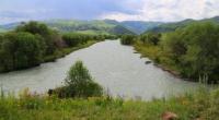
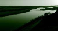
Yertis river.
Yertis river (total length is 4248 km; length on the territory of Kazakhstan is 1700 km). Its tributaries are located in China. The river named Black Irtysh comes to the territory of Kazakhstan and flows into Zaisan Lake. From the lake it flows under the name of White Yertys, or just Yertys, and it flows into Ob River.
Near Ust-Kamenogorsk, Yertys accepts a lot of tributaries, amongst which the largest is Bukhtarma. Between Ust-Kamenogorsk and Semipalatinsk the river’s largest tributaries are: from the right side – Ulba and Uba Rivers, from the left side – Char and Kyzylsu Rivers.
Yertys is navigated along the total length. Passenger vessels and boats swim upstream to the border with China. Yertys River is rich with fish that has commercial value. It is inhabited by sterlet, white salmon, stellate sturgeon, sturgeon, pike, perch and crucian carp.
Recently such fish as sazan, bream, pike perch and Baikal omul were brought here. Left tributaries of Yertys, Yesil and Tobol, flow along the northern oblasts of Kazakhstan and flow into Yertys outside of the country. Yesil (length on the territory of Kazakhstan is 1700 km) starts in Central Kazakhstan and flows into Yertis.
Tobol river.
Tobol river (length on the territory of Kazakhstan is 800 km) starts on the eastern slope of Southern Ural, flows along Kazakh territory and flows into Yertys on the territory of Russia.
Uba river.
Uba river is the right tributary of Irtysh, flows along East-Kazakhstan oblast. Its length is 278 km, the area of the basin is 9850 sq. km. It is formed due to the merger of Black and White Uba. Uba, like other rivers in Rudny Altai - Ulba, Narym, Kurchum and Kalzhir, has pure transparent water thanks to its natural filters – stony channel, sandy riverbanks and riverbed.
Ulba, the right tributary of Irtysh, flows into it near Ust-Kamenogorsk. Its length is around 100 km, the area of the basin is 5091 sq. km. It is formed due to the merger of Gromotukha and Tikhaya Ulba rivers that start in Ivanovo and Uba ridges (Rudny Altai). Its main tributary is Malaya Ulba.
Kurchum river.
Kurchum river is the right tributary of Yertys. Its valley is bounded from the left side by Kurchum Ridge and from the right side by Sarymsakty Ridge that separates Kurchum basin from Bukhtarma basin. The river heads are located not far from Markakol Lake in the area of woodland taiga where Kurchum is meandering and fast mountainous taiga river with the width up to 25 m.
Length of the river is 210 km. Kurchum flows into Bukhtarma Reservoir (Zaisan Lake). Kurchums’s tributaries are Kunduzdy, Kurkuldek and others.
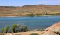
Ili River.
The name of the river comes from the Mongolian word “Ilansu” that means twinkling, sparkling. Ile is formed due to the merger of Kunges and Tekes rivers that flow from Central Tien Shan. On the territory of Kazakhstan it flows along the intermountain plain, its valley is wide and flat.
The river stream often is branched into the channels separated by the islands overgrown with bushes and rush. The river valley gets narrower only in the area of Kapshagai Ravine, after that it becomes the lowland river. Ile flows into Balkhash with several branches (bakanas) forming wide delta.
Basin of Caspian Sea.
Ural river.
Ural river starts in the Ural Mountains, crosses Western Kazakhstan from the north to the south and flows into the Caspian Sea. Total length of Ural is 2428 km, length on the territory of Kazakhstan is 1082 km. Ural’s main tributaries are Sakmara, Chagan, Yelek, Or.
And such tributaries as Olenty, Buldyrty, Kaldygaity, Uil, Sagyz get dry not even reaching Ural. The river is suitable for navigation. Here is found sturgeon, stellate sturgeon, sazan, catfish, pike perch, bream, perch and chebak.
Emba River.
Emba River also refers to the basin of the Caspian Sea. Except for high-water years, the river not reaching the sea will be lost in sands. Uil, one of the tributaries of Ural, starts in the Ural Mountains. The length of the river is 800 km.
Emba starts in the north-west of Mugodzhary Mountains and flows into the Caspian Sea.
The length of the river is 635 km. Syrdariya starts outside of Kazakhstan in the mountains of Tien Shan. The length of the river is 2212 km. In the middle stream and downstream (1400 km) it flows along the the territory of the country.
Syrdariya river.
Syrdariya river is the most turbid river in the republic (water turbidity is 1200g/mole3), that is why on its way it washes away friable rocks forming flood-lands with the width of 10-15 km. During strong floods Syrdariya sometimes goes out of the banks and it floods the lower part of the river valley.
In sand tracts Kyzylkum you can meet many old dry channels: Zhanadariya (300 km), Kuandariya (325 km). Due to the maximum use of the river water for the needs of the national economy from 1974 the river does not bring its waters to the Aral Sea: it crosses Kyzylkum, Aryskum and Aral Karakumy and it is lost in sands.
Only one tributary flows into Syrdariya on the territory of Kazakhstan – Arys River. To the east from the Aral Sea there are several small lakes. A lot of small rivers and springs flow into them. The most significant of them are Chu, Sarysu, Turgai and Irgiz.
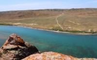
Balkhash-Alakol Basin.
Ile is the largest river in Zhetysu. It is formed due to the merger of Tekes and Kutes that start from Eastern Tien Shan. The length of Ile River is 1439 km, the length of the river on the territory of Kazakhstan is 815 km. The river starts in China, on the territory of Almaty oblast it forms the artificial reservoir Kapchagai, and it flows into Balkhash Lake.
Large tributaries of Ili are Turgen, Talgar, Kurty, Chilik, Charyn, Usek. Ile flows into Balkhash with several branches (bakanas) – Shetbakanas, Ortabakanas, Narynbakanas forming the wide delta. The river is navigated to the border with China and further upstream.
In the flood-lands of Ile River in rushes, tugai, there are sazan, pike and other fish. There are also musk-rats, cane cats, zhetysu pheasants, white-head cranes.
Authority:
“Central Asia Mountains”. 2009, Almaty,Publishing house “Mektep”. Authos Aldar Gorbunov, Anna Ivachenko, Sharipa Bisarieva.
Photos
Alexander Petrov.