You are here
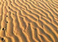
Sands Sauskan on Mangystau.


Climbing tour on Mangyshalk.
“The world is a book and those who do not travel read only one page”
Augustine of Hippo.
Hiking group sights in Mangyshlak.
Sands Sauskan are in Mangystau district of in region of same name, are located on the Ustyurt plateau. In a northwest part sands Sauskan border on sands Baskuduk, in the southeast closely border on sands Bostankum.
The border Sauskan and sands Bostankum can be considered sand the Central Asia-Center gas pipeline. Extent of sands from the northwest on the southeast of the 35th kilometer, width in a middle part, the most extended part, - 17 kilometers.
In east part on border of sands there is a settlement of Syzdy, in a northwest part - the big settlement of Ushtagan. In a southwest part of sands there is a small settlement of Zharma. From the South on the North sands are cut by the highway which conducts from the settlement of Kyzylsay to the settlement of Syzdy, 40 kilometers long.
In the southern part of sands the mountain Tortkol 237,1 meter high above sea level is located. Sands Sauskan of ridgy height of a ridge are 10 - 15 meters, depth of sandy cells, also from 10 to 15 meters. As sands are on a sublime surface, the central part of the Ustyurt plateau the greatest heights of a ridge of sands reach 229 meters above sea level.
Geographical coordinates of central part of sands Sauskan: N43 °45'41 E52 °56'56
Authority and photos by:
Alexander Petrov.


