


![]()
You are here
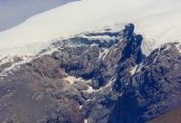
Sapozhnikov Northern Glacier in Big Almaty Gorge.
Nels mountains Northern Tien-Shan.
“Always keep a clear head and be prepared to work in any conditions and to face any surprises. To do this, you need to comprehensively and constantly prepare. And then you can enjoy the beauty of the mountains and enjoy the climb itself."
Evgeny Vinogradsky.
Mountain travel in Zailiyskiy Alatau.
Northern branch of Sapozhnikov glacier is located at an altitude of 4127 to 3741 m. a. s. l., located on northern slope of Zailiysky Alatau ridge, in upper reaches of Big Almaty gorge at head of Ozernaya river, in eastern part of Ozerny pass in Bostandyk district of Almaty.
The glacier is named after V.V. Sapozhnikov (1861-1924), a botanist and geographer, traveler. Most of the Sapozhnikov glacier is located on the southern slope in Kyrgyzstan and belongs to the Chon-Kemin river basin. In the western part, a small glacier 1100 m. long separates from the main Sapozhnikov glacier through the crest of the ridge to the north.
The northern glacier is connected with the Sapozhnikov glacier in the south by a small bridge of 500 meters. There are two northern glaciers of Sapozhnikov, one of them, the western one, is separated from the eastern one by a small rocky cofferdam.
The perimeter of the eastern glacier reaches 2655 meters, the area is 0.32 square kilometers. Its length from north to south reaches 1000 meters, the maximum width is 420 meters. In the northern part of the western glacier, 380 meters, at an altitude of 3546 meters above sea level, there is a moraine lake.
The lake is 77 meters long and 30 meters wide. The perimeter of the eastern Sapozhnikov glacier is 3831 meters, the area is 0.65 square kilometers. The glacier is 1324 meters long, the maximum width in the southern part is 805 meters.
The eastern Sapozhnikov glacier in the east is bordered by the Chernyi glacier.
One of the sources of the Ozernaya River begins from the northern part of the glacier.
Geographic coordinates of the Sapozhnikov glacier: N42°57'36 E77°02'01
Authority and photos by:
Alexander Petrov.