


![]()
You are here
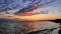
Sarytash Bay.
Sights of Mangystau region.
"Knowledge of other worlds has long been considered the main knowledge"
Trip from Boszhira valley to Beket-ata mosque.
The waters of the Mangyshlak Bay include the Koshak and Sarytash bays. Sarytash Bay is located in the northeastern part of the Mangyshlak peninsula in the Tyub-Karagan region in the Mangistau region. The bay juts out into the northern coast of the Tyub-Karagan peninsula. G.S. Karelin wrote that the bay got its name from a small limestone, yellowed by time, on which the preserved Turkmen seal was roughly carved.
The northern border runs from Cape Ashchyiuryn in the west and further east to the peninsula that divides the waters of the Mangyshlak Bay into Koshak and Sarytash bays. The length of the bay from west to east is 22.7 kilometers, the width from the northern border to the northern coast is 8.4 kilometers.
The depth of the eastern part of the bay is from 1 to 3 meters, the western part of the bay from Cape Ashchymuryn and further to the southeast and east of Cape Sultanape, the deepest is up to 27 meters. The central part of the bay does not exceed a depth of 5 meters.
In the 1930s, the Sarytash pier operated on the northern coast of the bay, from where coal was exported to Astarakhan from the coal mines in the village of Taushyk. The shores of the Sarytash Bay are low-lying and in places bordered by sandbanks.
Throughout the coast are cut by ravines and gullies and covered with sparse vegetation. At the entrance to the bay, Mount Ungoza with a height of 197.1 meters above sea level is noticeable.
Geographical coordinates of Sarytash Bay: N44°30'19.10" E51°08'40.19"
Authority and photos:
Alexander Petrov.
http://www.caspianmonitoring.ru/