You are here
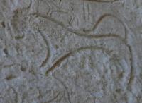
Сave drawing of Butentau.

Petroglyphs Tours in Turkmenistan.
“He who conquers himself is the mightiest warrior”
Confucius.
Museum Petroglyphs Tours in Turkmenistan.
The Butentau (Betendag) Upland is located 19 kilometers to the east and slightly north of Lake Sarykamysh, in the interfluve of Daryalyk and Kenederya and the ancient channel Gyaurchorun, 27 kilometers southwest of the Sabun'el sands, 3.2 kilometers northwest of the small the village of Bent in the west of the Turkmenbashi etrap in the northwestern part of the Balkan velayat.
The length of the elevation from north to south-east and south-west is 25 kilometers, the greatest width in the northern part is 5 kilometers. The highest elevation in the southern part, in the vicinity of the Imam Brahim Melgam mosque, reaches a height of 100.3 meters above sea level.
The northern height of the hill is located at an altitude of 88.2 meters above sea level. The upland is bounded on all sides by cliffs reaching the highest height of about 50 meters in the southern and southwestern parts. In the northeast of the outlier upland, the chinks decrease to 20 meters.
At the foot of the northeastern slope of Butentau, the Daryalyk channel runs, and along the southwestern one of its channels, the Kichkine-Darya. The Kyrk deshik tract is located 96.7 kilometers to the west and slightly south of the city of Kunya-Urgench, in the southeastern part of the Butentau Upland.
At the southern end of the chink there is a mazar Ibraim-Medem (geographical coordinates of the mosque-mazar Ibraim Medem (Imam Ibrahim Melgam): N42 ° 02'34.81 "E57 ° 58'03.40"), associated with the legendary Arab Ibrahim, who, according to legend brought Islam to these places and created the Butentau hill in one day.
This legend is associated with one of the versions of the translation of Butentau - "the mountain that came". Artificial caves are located in the southeastern and northwestern cliffs of Butentau. They are located in groups with large breaks (up to 5 kilometers), but along the southeastern cliff of the cave they form a continuous line about 3.5 kilometers long.
This is Kyrk deshik. Opposite this group of caves is the early medieval fortress Adak (Okcha kala), on the site of which the late medieval fortress Ak kala was built (geographical coordinates of the Ak Kala settlement: N42 ° 03'49.21 "E58 ° 02'26.78"), the ruins of which are well preserved to the present day.
At the top of Butentau, at its northern tip, there are the remains of two ancient fortresses - Butentau kala 1 (geographical coordinates of the settlement of Butentau kala 1: N42 ° 12'49.72 "E58 ° 03'39.35") and Butentau kala 2 (geographical coordinates fortified settlements Butentau kala 2: N42 ° 12'41.06 "E58 ° 03'42.17").
The caves were cut in a layer of marl with a thickness of 1.3 - 1.5 meters and in some places are located in two tiers at a height of about 5 meters from each other. At the base of the upland, powerful talus formed almost everywhere, consisting of rock fragments and products of its destruction.
The caves are practically inaccessible from below and from above, as they were cut down on completely steep sections of the chinks, often under cornices protruding two or three meters. From its southeastern side of Butentau, 228 entrances of the first tier and 51 entrances of the second tier were recorded.
Each cave has one to twelve entrances and one to six rooms. In total, 91 caves of the lower tier and 28 caves in the lower tier were surveyed. Petroglyphs are carved on rock fragments, on the walls of chinks and on the inner walls of caves.
In addition to petroglyphs, signs similar to runic letters were found. Drawings and runic signs were cut with a sharp tool into the limestone rock to a depth of 0.1 mm to 2 cm. Stones with images at the foot of the hill are covered with "desert tan" of varying intensity.
Often there is an overlap of drawings on top of each other, which may indicate their difference in time.
Geographic coordinates of the Butentau Upland (Betendag): N42 ° 06'48.28 "E58 ° 03'29.98"
Geographic coordinates of the Kyrk deshik valley: N42 ° 04'07.73 "E58 ° 01'43.48"
The petroglyphs of the surroundings of Lake Sarykamysh are diverse both in theme and style. Linear-geometric compositions prevail, there are images of people and wild animals.
During the examination of the caves, various household items were found, ceramics of the XIIth - XIIIth centuries. and a XVth-century manuscript, which determine the probable age of the bulk of the rock carvings in the caves.
It is also assumed that some part of the petroglyphs may date from earlier historical periods. (Tolstov, 1958: 84).
Authority:
Edjegul Muradova.
Photos by
Alexander Petrov.


