


![]()
You are here
Seas and lakes in Kazakhstan.
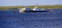
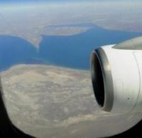
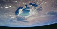
Photo Gallery 100 Nature Wonders of Kazakhstan.
“It is untrue that equality is a law of nature. Nature has no equality; its sovereign law is subordination and dependence”
Luc de Clapiers de Vauvenargues.
Natural Wonders of Central Asia.
There are more than 48 thousand lakes in Kazakhstan. The largest amongst them are the Aral Sea, Balkhash, Zaisan, Alakol, Tengiz, Seletengiz. Almost all lakes are closed. Water in the majority of lakes is saline, and most of them are used for salt extraction.
One of the peculiarities of Kazakhstan is the uneven distribution on the territory of the republic. Depending on the climatic conditions the number of lakes diminishes from north to south. The number of fresh-water lakes diminishes towards the south and the number of saline lakes increases.
Large number of lakes is situated in the Caspian and Turan Lowlands, Western-Siberian Valley, in the lowlands of Saryarka and south-eastern mountainous areas. At present there are more than 4 thousand reservoirs in Kazakhstan with the total area of 10 thousand km2.
They accumulate the fresh-water reserves of 90 km3.
Most of the reservoirs are located in Central, Southern and Eastern Kazakhstan. These are Bukhtarma, Kapchagai, Shardara, Samarkand, Bugun, Akkol, Molodezhnoe, Sherubai-Nura, Kengir, Ust-Kamenogorsk reservoirs and others.
Caspian Sea is the largest closed lake of the world. It is located between Europe and Asia. Due to its size it is called a sea. The length of the coastline of the Caspian Sea is 7000 km. Its waters wash the coasts of five countries.
Kazakhstan has 29% (2340 km) of the coastline, the major part of the northern and half of the eastern coast of the Caspian Sea. There are 769 species of animals, 55 species of fish (the most valuable are beluga, sturgeon, stellate sturgeon), more than 500 species of plants in the Caspian Sea.
The share of the Caspian Sea is above 80% for sturgeon caught in the world annually. 40% of the sturgeon caught belongs to Kazakhstan. In the Caspian Sea there are also sazan, vobla and other fish. Within Kazakhstan Ural River with its tributary Ilek and Emba River flow into the Caspian Sea.
Aral Sea is the lake that is located in Turan Lowland.
With regard to its size, the Aral Sea is the second in Kazakhstan and it is the fourth in the world. It is situated between Kazakhstan and Uzbekistan. In 1961 the water level in the Aral Sea was 53 m above the level. Its area was 66.1 thousand km2, water volume was 1064 km3, length was 428 km.
Due to the intensive use of the water from the rivers in the economy, this area was subject to significant man-caused impact and as a result in 2002 the level of the sea went down by 20 m. This is related to irrevocable water intake that flows into the sea.
Thus, Syrdariya River from 1974 and Amudariya from 1982 were not always reaching the sea. There were 1100 islands in the Aral Sea, part of them like Kokaral, Barsakelmes and Revival Island became the peninsulas, i.e. joined with the land.
Due to the reduction of the water level in the Aral Sea, the territory occupied by it was diminished by 40 thousand km2. The sea was divided into two parts: Large Aral and Small Aral. The banks of the lake ebbed by 100 - 150 km.
The dried up sea bed turned into the alkaline lands, deserted banks became covered with salt and sand. In order to save Aral in 1992 the first “Ecologic map of Aral Region” was created in Kazakh air-space ecological centre in Baikonur. In 1994 the Central Asian countries established Aral Salvation Fund.
Balkhash is the third lake in Kazakhstan by the territory after the Caspian and Aral Seas. It is located in the south-east of the country in Balkhash-Alakol Depression (342 m above sea level). The area of the lake is 18.2 thousand km2, the length is 614 km, the largest width is 74 km, the length of the bank line is 2383 km.
Water volume is 106 km3. Balkhash is divided into two parts: western and eastern. The depth of the western part is 6 - 12 m, the depth of the eastern part is around 15 - 26 m. The lake is cut by multiple peninsulas and bays.
The largest islands are Basaral and Tasaral. Besides Ili, Balkhash has such tributaries as Karatal, Aksu, Lepsy, Ayaguz, Bakanas and other rivers. Significant amount of water (675) in the lake is brought from Ili River.
The phenomenon of Balkhash is in different mineralization of its western and eastern parts connected by the narrow belt. The western basin that receives water from Ili River is fresh water and the eastern part is saline water.
The nature of Balkhash is amazing and full of contrasts. There are more than 20 species of fish in Balkhash including six local species that are there from the ancient times (Ili blue-head, Balkhash blue-head, Balkhash perch and others), the rest were brought from other water reservoirs (barbel, barbel sturgeon, pike perch).
Commercial fish is sazan, pike perch, Balkhash perch and others. Alakol (variegated) is one of the most beautiful lakes in Kazakhstan. Besides beneficial water the saline lake is rich with curative mud, mineral salts. It is located in the north-eastern edge of Zhungar Alatau.
In Ptichy Island (Bird Island) there are flocks of flamingo. This area is inhabited by more than 40 species of birds. Markakol is the most beautiful high-mountain lake in Eastern Kazakhstan. Markakol lake spreads in length for 38 km and its width reaches 19 km. The area of the lake is 455 km2.
The shoreline of Markakol is stretched almost for 100 km2. The lake is relatively deep: its average depth is 14 meters and the maximum depth is 30 meters. The lake is located at the height of 1447 m above sea level, in the inter-mountain depression between Kurchum Ridhe in the north and Azutau Ridge in the south.
Around 100 small rivers and springs flow into Markakol. And only one river flows out of the lake – Kalzhir. One of the remarkable sights in the lake is that it contains very rare fish - uckuch. Uskuch is the type of Siberian lenok (Brachymystax lenok savinovi Mitrofanov), it can be met only in Markakol.
All the fish in Markakol after the lake isolation that took place during the inter-glacial period formed the independent subspecies and became endemics. Such lenok like in Markakol can not be found anywhere in the world. Lake umber is quite different from the river umbers (Thaymallus arcticus brevicephalus).
The lake and its area are the national reserve since 1976. Rakhmanov mineral sources are located in the beautiful depression of Rakhmanov Lake (area is 1.14 km2), in its north-eastern bank, along the right side of Arasan River Valley.
Thermal sources flow from the northern side of the area from the cracks formed due to the contact of granites and slates in the direction from east to west and almost all of them are along one line with the total length of about 80 m.
The water of Rakhmanov Springs is colourless, very pure, does not practically contain suspended solids and does not have any specific taste, and it is nice to drink. According to historical data, there were the ruins of the Buddhist joss-house in the area of Rakhmanov Springs.
Karasor (or Tuzdykol) has the area of around 250 km2. The lake is rich with fish. Salt content in the water of Karasor exceeds the salt content in seawater. On its banks there is curative mud. Around ten small rivers bring their waters to Karasor Lake.
Bukhtarma Lake. The nature of this region is magnificent and beautiful. Emerald Bukhtarma Lake is famous for its picturesque sights. A lot of rivers and springs, which flow from the mountains, flow into the lake forming beautiful waterfalls. And only one river flows out of the lake – Shandage-Bulak.
Bolshoe Almatinskoye Lake is a mountainous lake located in the ravine of Bolshaya Almatinka River, at the height of 2511 m above sea level, 28.5 km to the south from Almaty City. It is located in the depression like a sparkling mirror surrounded by the mountain tops from all the sides.
Above the lake there are three main peaks: Sovetov Peak (4317 m), Ozerny Peak (4110 m) and Tourist Peak (3954 m). To the west from Tourist there is the ridge of Bolshoi Almaty Peak (a pyramid with the height of 3681 m), which can be seen from the centre of the city.
The lake that is fed with the glacier water represents a 1.6-km bowl, with the width almost one km and with the depth of 40 m. Depending on the season, the colour of the lake changes from pale-green to turquoise-blue.
Kolsai Lakes are called the pearl of Northern Tien Shan. Three high-mountainous lakes with steep, overgrown with fir-trees slopes are located in Kungei-Alatau Ridge. Each lake has its charm. There is the king fish in the crystal pure blue water - coast rainbow trout.
The first lake spreads for 1 km at the height of 1818 m. The middle Kolsai Lake (2252 m) is the biggest and it is beautiful. It is located in 5 km from the first lake. Upper Kolsai is located 4 km further and it is 600 m higher. After 6 km, on Kyrgyz border, there is Sary-Bulak Pass (3278 m) with the magnificent views to blue lake Issyk-Kul.
Kaindy Lake (“Birch Lake”: translation from Kazakh) is located amongst the magnificent coniferous forest at the height of 2000 meters above sea level. The length of the lake is about 400 m and its depth is almost 30 m. From the ridge of the rocks you can see beautiful scenes of Kaindy ravine, Saty, Valley of Chilik River.
Zaisan Lake. In the south-east there is vast deserted Zaisan depression, on the bottom of which there is the ancient lake Zaisan. Once on its banks and in the lake there were dinosaurs. In Zaisan it is possible to catch such fish as pike, pike perch and other species.
When the evening starts appear above the lake you can hear the melodious ring like the buzz of wires. Due to this peculiarity the lake is called “Lake of ringing bells” – Hut-Hutu-Nor. Sibinsky Lakes. Kalbinsky Spine is the area of very beautiful lakes.
They are located in the frame of granite sandy rocks, plate-like rocks. They are five: Kashkerbai (Sassykkol); Alka (Korzhynkol); Ulmeis (Shalkar); Gnuisen (Tortkarakol). The lakes are located in tiers, near the southern edge of Koktau massif.
There are the ruins of the ancient Buddhist temple Ablaiskit in the first lake, where the enormous library of Tibet roll books was found and where, according to legends, there was the treasure, which contained the golden statue of Buddha of the size of a man.
The temple was on the bank of Sassykkol Lake, in the granite massif. The largest lake is Ulmeis where the fans of underwater swimming can go in for diving.
Authority:
"Zhetysu is the Land of tourism”. A Tourist Guide-book. Almaty. 2003. 68 p. and the material for this page is taken from the printed edition.
Photos
Alexander Petrov.