







You are here
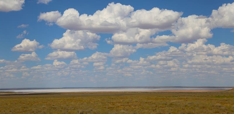
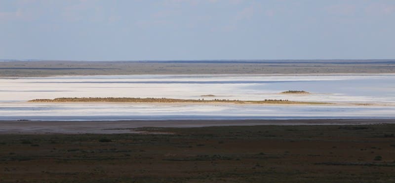
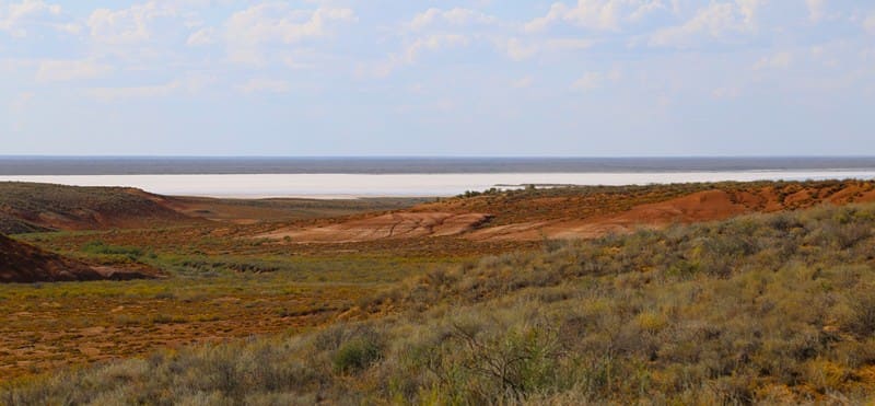
Tamgaly Salt Marsh.
Salt marshes of western part of Betpak-Dala Desert.
"3rd. On this day, the sands ended. The hike was 25° until midday, and from midday onward, 75° to the Tamgaly tract, from which a freshwater spring flows. The route is sandy, with numerous salt marshes and, in many places, small hills containing a considerable amount of iron. There are quite a few forests. We spent the night near this spring (55th century). A Cossack's horse died near this place."
Records of the trip of Cossack Ataman Second Lieutenant Dmitry Telyatnikov and Sergeant Alexei Beznosikov from the Irtysh Line to the Tashkent domain to see the ruler Yunus-Khoja (May 30, 1796 – July 23, 1797). "Journal of the campaign of Second Lieutenant and Ataman Telyatnikov to Tashkent with a description of the route, location, and other details, as described by Sergeant Beznosikov. May 1796."
A trip to Tamgyl Salt Marsh in Turkestan Region.
Tamgaly Salt Marsh is located at an altitude of 156 m. a. s. l. in the western part and 157 m. s a. s. l. in the eastern part. It is located eastern of the Sarysu Valley, north of the Tamgalyzhar cliffs and tract, in the western part of the Betpak-Dala Desert in the Sozak District in northwestern Turkestan Oblast.
Tamgaly Salt Marsh consists of two parts – Western and Eastern.
Tamgaly Salt Marsh is a little-known salt marsh complex in western Betpak-Dala Desert.
Situated in the inaccessible western part of the Betpak-Dala Desert is one of the little-known natural features of the Sozak District: the Tamgaly Salt Marsh. Due to its remoteness from populated areas and the lack of permanent roads, this area is rarely visited by tourists and remains little-studied even by travel enthusiasts.
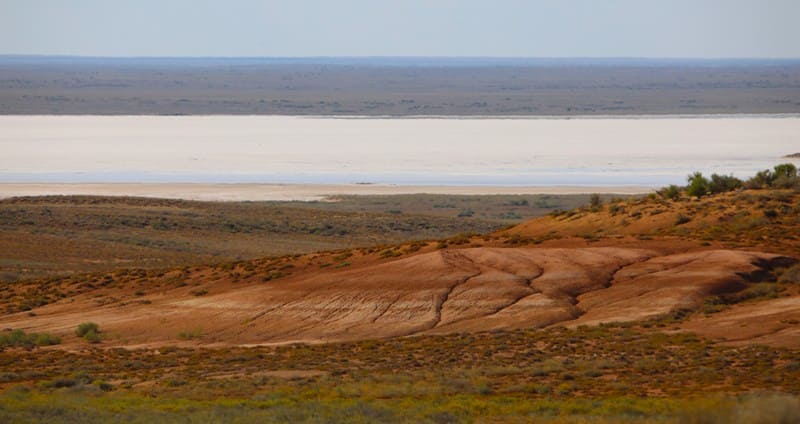
The salt marsh is located in the northwestern part of the Turkestan Region, within the Sozak District, east of the Sarysu River valley and north of the picturesque cliffs of the Tamgalyzhar tract. The absolute elevation of the area is 156-157 meters above sea level, indicating the almost perfectly flat surface of an ancient aggradational plain.
Unlike many small salt marshes in southern and central Kazakhstan, Tamgaly is a single natural complex consisting of two large, isolated areas: the Western and Eastern. Between them lies a low watershed formed by ancient alluvial and eolian deposits.
The western part of the salt marsh extends from south to north for almost 9.6 kilometers. Its greatest width in the southern part reaches 4.1 kilometers, and its total area is 19.07 square kilometers. The coastline is 23.32 kilometers long, indicating the complex configuration of its margins.
The eastern part is significantly larger. Its south-to-north length is approximately 8.5 kilometers, its maximum width in the central part reaches 7.5 kilometers, and its area is 43.16 square kilometers. The coastline extends for 30.47 kilometers. Together, the two basins form one of the largest salt marsh massifs in western Betpak-Dala, with a total area of over 62 square kilometers.
Physical and geographical characteristics of Tamgaly salt marsh.
The formation of the salt marsh is associated with the relief features of Betpak-Dala. For millennia, precipitation and temporary streams flowed into the depressions of the ancient plain, without surface runoff. The water gradually evaporated under the influence of the hot and dry climate, leaving dissolved mineral salts on the surface.
This process, repeated over many thousands of years, led to the formation of thick salt horizons. The modern topography is exceptionally flat. The difference in absolute elevation between the western and eastern parts is only about one meter, allowing certain areas to be temporarily covered with a thin layer of water during the spring snowmelt and after heavy rains.
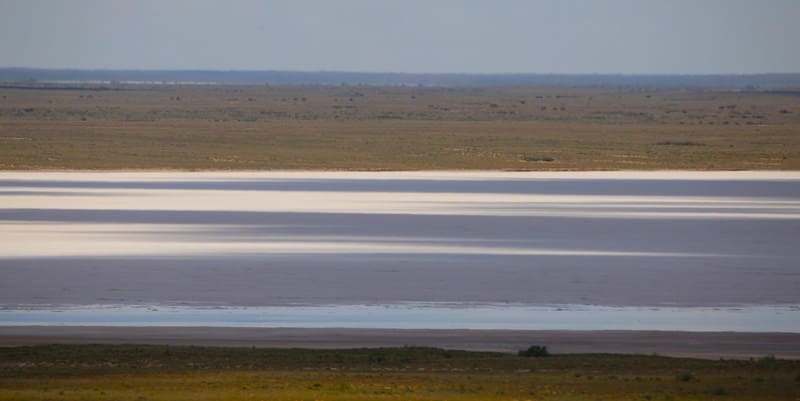
With the onset of summer heat, the water quickly evaporates, leaving a characteristic white salt crust. The soils are predominantly solonchaks with a high content of readily soluble salts. In some places, the surface takes on a light gray or almost white color, contrasting sharply with the surrounding brown desert plains. In dry weather, the salt crust often cracks, forming bizarre polygonal patterns - a characteristic feature of salt marsh landscapes.
The vegetation here is extremely sparse. Halophytes - plants adapted to high soil salinity - are found along the outskirts. In the most saline areas, vegetation is virtually nonexistent.
Natural Significance of Tamgaly Salt Marsh.
The Tamgaly Salt Marsh is a typical example of a closed salt marsh depression in the Betpak-Dala Desert. Such natural complexes play an important role in the formation of local ecosystems. In the spring, they can serve as temporary concentration sites for migratory birds, and along the periphery, they create special conditions for the existence of specialized desert vegetation.
Furthermore, the salt marsh serves as a unique indicator of natural processes, reflecting the characteristics of the modern climate, surface and groundwater regimes, and the centuries-old history of the development of the desert landscapes of southern and central Kazakhstan.
Tourist Value of Tamgaly Salt Marsh.
Despite its harsh natural conditions, the Tamgaly Salt Marsh is of great interest to lovers of geography, geology, and landscape photography. Snow-white salt fields stretching to the horizon create unusual landscapes, especially spectacular in the morning and evening hours, when the surface reflects sunlight and takes on silvery hues.
The remoteness of this area from populated areas has preserved it in a virtually pristine state. However, a trip here requires considerable preparation. A four-wheel drive vehicle, sufficient fuel and water, navigation aids, and experience navigating desert terrain are essential.
Today, the Tamgaly salt marsh remains one of the little-known natural features of Betpak-Dala. The lack of detailed publications makes it particularly interesting for researchers and travelers seeking to discover little-known corners of Kazakhstan.
History of Exploration of Area Around Tamgaly Salt Marsh.
“If we follow to the east from the north-western corner of the ledge, which abuts with its blunt rounded cape on the Pok-karayun tract, which is a continuation of the Kyzyl-Dzhingildy tract and consists of continuous wet solonetzic sors, where horses get stuck up to their bellies, then after 22 versts we reach the Tamgaly-tasa tract, which is located on the top of Tamgaly-dzhar and is famous for its sacred stone; this stone belongs to sandstone, 3 cubic fathoms in size, with wedge-shaped hieroglyphs carved on it and colored patches, with which the Kirghiz decorated the surrounding stones and boyalish bushes; this custom was adopted from the Mongolian peoples and expresses a sacrifice for the safe passage of the desert; nearby is a large Kirghiz cemetery. The Tamgaly Spring is located at the top of a ravine, 100 fathoms from the rock, and the water collects in a depression, like a well. It is 1/2 arshin wide and long, and 2 arshins deep. Three miles west and east of Tamgaly-tas are other springs located in depressions with a lesser influx of water. The main, central spring contains fresh water, filling to the brim within an hour. The excess water flows down the ravine as a weak stream. The area around the spring is overgrown with bog grass, in which steppe hares nest. The ledge of the wall and ravine near Tamgaly-tas provides an excellent cross-section for examining the arrangement of layers of different clays. Under a foot-thick layer of sandy pebbles on the surface, the clay layers are arranged in the following order downwards: a three-fathom layer of yellow clay, a two-fathom layer of reddish clay, a four-fathom layer of dark red clay, a one-and-a-half-fathom layer of blood-red clay, a four- to four-and-a-half-fathom layer of light-red clay, a five-fathom layer of light-colored clay shales; adjacent to the lower part are deposits of clays washed away from the spring, and at the very foot there is a vast solonetz with a three-inch-thick layer of Tamgala-tuz salt efflorescence. In this way, the northern ledge of the desert extends to the east right up to the Terskende-bulak tract, and short ravines deeply furrow the soft clays of the steep slope. There are three Terskende springs; all of them are located on the upper edge of the ledge in a ravine, forming three separate basins close to one another; "These pools consist of deep pits, 2 fathoms in diameter and 1/2 arshin deep, the influx of water is very abundant and the water is completely fresh; around the pool and along the stream of water, which flows down the ravine into the Chingilda salt licks, located at the foot of the ledge."
Yu. A. Schmidt. "Field, Astronomical, and Meteorological Measurements in the Sarysu Valley Associated with the Preparation of this Area of the Akmola Region for Topographic Surveying in 1888-1889." Schmidt, 1894.
The Tamgaly Salt Marsh takes its name from the Tamgaly Spring, which is located 2.6 kilometers southeast of the Western Tamgaly Salt Marsh. The spring was known before it was visited by D. Telyatnikov and A. Beznosikov in 1796. The trade caravan route from European Russia to Central Asia, to the Bukhara Khanate, ran northwest to southeast (Orenburg - Petropavlovsk - Tashkent).
Given the frequent waterless areas, the trade route followed lakes, rivers, and springs, which were essential for watering camels and horses. Some of the earliest and first mentions of the area around the Tamgaly salt marsh come from the records of the Cossack ataman, Second Lieutenant Dmitry Telyatnikov, and Sergeant Alexei Beznosikov, who traveled from the Irtysh line to the Tashkent domain to see the ruler Yunus-Khoja (May 30, 1796 – July 23, 1797).
The journal "Journal of the campaign of Second Lieutenant and Ataman Telyatnikov to Tashkent with a description of the route, location, and other details described by Sergeant Beznosikov. May 1796." In his diary, Alexei Beznosikov mentions only the Tamgaly spring, ancient Kyrgyz burial sites, and a rock outcrop.
Then A.I. Shrenk visited these areas near the Tamgaly salt marsh in 1840-1843, exploring the western end of the Betpak-Dala desert. This place is mentioned by the Russian military historian M. I. Ivanin (1801-1874), a participant in the Khiva campaign of 1839-1840, in a note to a review of accounts by Eastern authors about Timur's campaign against the Golden Horde in 1391.
In 1877, Major Kalugin, head of the Perovsky district of the Syr Darya region, visited this sparsely populated area on a business trip and compiled a schematic map.
Between 1888-1889, the Tamgalyzhar tract, the Tamgaly spring, and the salt marsh of the same name were visited by military surveyor Yu. A. Schmidt. His work, "Field, Astronomical, and Meteorological Measurements in the Sarysu Valley Associated with the Preparation of this Area of the Akmola Region for Topographic Surveying in 1888-1889," provides the first detailed description.
In October 1934, the Tamgalyzhar tract, the Tamgaly spring, and the salt marsh of the same name were visited by zoologist Viktor Alekseevich Selevin (1905-1938) as part of the Betpak-Dalinsky expedition, which also included Karpenko and Mironov.
In 1958, a KRoA expedition consisting of Lisunov and Mikhailov visited the Tamgaly salt marsh area.
Geographic coordinates of Western Tamgaly Solonchak: N45°53'19 E67°33'25
Geographical coordinates of Eastern Tamgaly Solonchak: N45°54'27 E67°37'46
Authority and photos:
Alexander Petrov.