


![]()
You are here
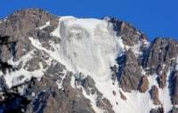
Toktogul glacier. Kyrgyz ridge.
Glaciers northern slope of Kyrgyz ridge.
“Stars the size of a fist pulsed above us. They broke off and fell to our ground. Fantastic Starfall! The moon hung overhead, and it seemed very easy to reach it with your hand…"
Mikhail Turkevich.
Walk to Toktogul glacier from Alamedin gorge.
The Toktogul glacier is located in the upper reaches, between the Alamedin and Altyn-Ter rivers, descends from the crest of the ridge into the valley of an unnamed river, is located on the northern slope of the Kyrgyz Ala-Too in the Alamudun district of the Chui region.
The perimeter of the Toktogul glacier is 9352 meters, the area reaches 3.86 square kilometers. The length of the eastern branch of the glacier is 1430 meters, the width of the southern part of the eastern branch is 1270 meters.
The length of the western branch of the glacier is 2350 meters, the width of the northern part of the western branch is 1550 meters. In the southeastern part of the ridge separating the Toktogul and Tuyuktor Zapadny glaciers, there is the Georgiy Sedov pass, 4280 meters above sea level.
Through the Georgiy Sedov pass, the Toktogula glacier has a small ice bridge with the Western Tuyuktor glacier. In the western part of the glacier, there is the Obzorny pass, 4250 meters above sea level, the path through which leads to the gorge of the Altyn-Ter river. In the south and southwest, the glacier borders on the Natalya glacier.
To the east of the Toktogul glacier are the Striikov and Krasivy glaciers. In the southeast is the Cherkasov glacier. From the southeastern part of the glacier, the source of an unnamed stream originates.
Geographic coordinates of the Toktogul glacier: N42 ° 26'05.82 "E74 ° 37'34.45"
Authority and photos by
Alexander Petrov.