


![]()
You are here
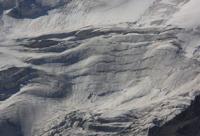
Top-Karagai glacier in Ala-Acha gorge.
Tourist routes of Ala-Archa park.
“I remember that winged land,
There are mountains in a cheerful crowd
They converged at the green river,
As if at a watering hole"
Yuri Vizbor. "Blue Mountains". 1956.
Main tourist sights of Ala-Archa park.
Top-Karagai glacier is located on northern slope of Kyrgyz Ala-Too ridge, in lateral (eastern) Ala-Archa gorge, 45 kilometers south and slightly west of city of Bishkek in Alamudun district of Chui region.
The origins of the glacier begin at an altitude of 4447 m. a. s. l., from the main ridge of the ridge. In the upper part, the glacier is located in an almost closed circus. In the east, the glacier borders on the Kara-Too (Mayakovsky) glacier belonging to the Alamedin river basin. In the north, the glacier is fenced off by a 4 km ridge that separates it from the valley of the Aksai glacier.
In the crest of the ridge, there is Svobodnaya Korea Peak with a height of 4,740 m. a. s. l. In the southeastern part, the glacier is adjacent to the southern exposure glacier - Altyntor Severny, belonging to the Alamedin River basin.
The length of the glacier is 7.8 kilometers, including the moraine part.
The open part of the glacier is 5.2 kilometers. The perimeter of the glacier is 11583 meters, the area of the glacier is 2.83 square kilometers. The length of the moraine part of the glacier is 2.5 kilometers. The tongue of the moraine part of the Top-Karagai glacier is located at an altitude of 3359 m. a. s. l.
The tongue of the open part of the glacier is located at an altitude of 3689 m. a. s. l. In the northern part of the glacier, there are several moraine lakes at an altitude of 3684 m. a. s. l. From the Topkaragai glacier flows the river of the same name with a length of 2.9 kilometers, which is the right tributary of the Ala-Archa river.
The mouth of the Top-Karagay River is located at an altitude of 2542 m. a. s. l.
Geographic coordinates of Top-Karagai glacier: N42°29'08 E74°32'59
Authority and photos by
Alexander Petrov.