


![]()
You are here
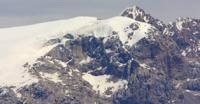
Tronov Glacier (Mukan).
Nature of Kora gorge in Dzungarsky Alatau.
“Personally, it seemed to me that we found ourselves in such a jungle, where nature goes to hide from itself, hide from its loneliness, from its decrepitude, from the fatigue of existence. And here she plunges into the memories of her youth, dating back to some era of the Paleozoic era, and, feeling the past touches of the ancient disappeared seas and the giant monsters that inhabit them, becomes alien to the modern world."
N. N. Palgov. "In Central Tien-Shan".
Tributaries of Kora River in Dzungarsky Alatau.
Tronov (Mukan) glacier is located on southern slope, in upper reaches of Kora gorge at head of Sheger-Bulak river in Dzungar Alatau ridge, in Eskeldinsky district of Almaty region.
The Tronov Glacier is 5.4 kilometers long, with an area of 11.86 square kilometers and a perimeter of 15.88 kilometers. The upper limit of the glacier is located at an altitude of 3727 meters above sea level. The tongue of the glacier is located at an altitude of 2970 m. a. s. l., belongs to the basin of the Kora River.
The small Bezsonov glacier, 4.9 kilometers long, is located 4.2 kilometers southeast of the Tronov Glacier. Sapozhnikov glacier, 3.3 kilometers long, is located 6.6 kilometers northeast of the Tronov Glacier. Altynsarin glacier with a length of 5.4 kilometers is located 8.1 kilometers northeast of the Tronov glacier.
From 1952 to 1972, the Tronov Glacier became shorter by 425 meters and lost 0.26 kilometers of square area. There are 1369 glaciers with a total area of 1000 square kilometers in the mountains of the Dzungarian Alatau. bout 42 kilometers of cubic water are conserved in glaciers.
Glaciers occupy an altitudinal belt from 3000 m. a. s. l. to the crest of the ridge 4000-4360 m. a. s. l. Moraines cover from 4-5% to 10 - 20% of the surface of glaciers. The firn line on the glaciers runs at an altitude of 3480 to 3840 m. a. s. l., depending on the exposure and morphological type of glaciers.
On the southern slopes the firn line is 100-120 meters higher than on the northern ones, on valley glaciers it is 70-80 meters lower than on the cirque ones. The main source of nutrition for the glaciers of the Dzungarian Alatau is atmospheric precipitation, most of which falls in the accumulation area in solid form.
The average amount of precipitation at the height of the supply line is about 900 mm per year, varying in different years from 770 to 1270 mm. The feeding boundary divides the glaciers of the Dzungarian Alatau into two parts approximately equal in area - the feeding area and the flow area.
The glacial coefficient of valley and basin glaciers averages 1.12, cirque glaciers - 0.89, hanging glaciers - 1.0. The predominant type of ice formation on the glaciers of the Dzungarian Alatau is firn and ice. The firn and ice zone covers most of the accumulation area above 3500 meters above sea level.
Below is a zone of ice feeding, which occupies approximately 20% of the area of glaciers. The process of ice formation in the first of the zones is completed within a few years, in the second - within one year. The daily rates of ice movement during the ablation period exceed the average annual rates by 1.2-1.4 times.
The main factor in the melting of glaciers in the Dzungarian Alatau is solar radiation. With a cloudiness of 4 points, its share reaches 74%, with a cloudiness of 6-7 points - 57% of the heat balance. The average daily ice melting at the ends of glacial tongues, depending on the weather, is from 2.2 to 4.6 cm, and in the middle parts of the glaciers - from 1.4 to 3.3 cm (in the water layer).
Glaciers lose more ice due to melting than they receive from the firn region due to movement. The mass balance of the glaciers on which observations were made is negative. The balance of the glaciers of the Dzungarian Alatau has been predominantly negative over the past few decades, as evidenced by the retreat of the ends of many glaciers and reduction in their area.
Geographic coordinates of Tronov Glacier: N44°53'22 E79°22'28
Authority and photos by:
Alexander Petrov.
"Glaciers". L.D. Dolgushin, G.B. Osipov. Series "Nature of the world". Moscow, publishing house.