You are here
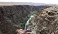
Valley Aktogay on Charyn river.

Hillwalking in Kazakhstan.
«A lake is the landscape's most beautiful and expressive feature. It is earth's eye; looking into which the beholder measures the depth of his own nature»
Henry David Thoreau.
Genealogy tourism in Kazakhstan.
Valley Aktogay (White Forest) is located at an altitude of 1195 to 1201.2 meters above sea level on the left side of the canyon of the Charyn River, is located on the territory of the Rayymbek district, in the southeast of the Almaty region.
Valley stretches from the southwest to the northeast for 3 kilometers along the left (northern) slope of the Albatross canyon on the Charyn River. This section of the canyon is interesting for sports rafting, it starts from the Zhalasay valley.
The Zhalasay valley is located on the right bank of the floodplain of the Charyn River in the west, and stretches for more than 8 kilometers to the east. In the Albatross Canyon there are several difficult rapids of a high difficulty category for passing, which require the highest skill of athletes.
From the surroundings of the tract, magnificent panoramas and views of the canyons of the Charyn River open up. There are about four such points from which fascinating pictures of bottomless canyons with steep, vertically falling rocks open down. In the vicinity of the tract, the width of the canyon reaches from 300 to 535 meters.
The depth of the canyon from the surface of the beginning of the slope to the river bed is 98 meters. From the road Kegen - Saty, passing to the north, country roads depart to panoramic sites, ranging in length from 2 kilometers to 600 meters.
The southeastern slopes of the Toraigyr mountains are located 6 kilometers northwest of the tract. From these mountains, in this direction, dry logs depart to the northern slopes of the canyon, in which rain and spring waters have washed deep channels.
Geographical coordinates of Aktogay valley on Charyn River: N43°15'25.78" E78°56'15.24"
Authority and photos by
Alexander Petrov.


