


![]()
You are here
West Tien-Shan Mountains.


Tours in mountains of Western Tien-Shan.
“The creation of a thousand forests is in one acorn”
Ralph Waldo Emerson.
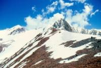
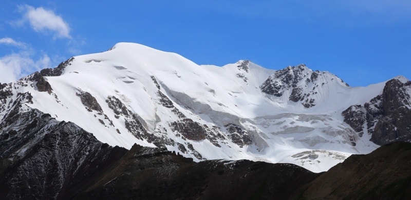
Sights of mountains Western Tien-Shan.
The mountains of the Western Tien Shan are located in the western part of the mountainous country Tien-Shan. The mountains of the Western Tien-Shan include the Talas Alatau ridge with ridges extending from it (from west to east): Ugamsky, Maindatalsky, Pskemsky, Chandalashsky, Chatkalsky. This region is located on the territory of the Jalal-Abad region of the Kyrgyz Republic, the Tashkent region of the Republic of Uzbekistan and in the Turkestan region of the Republic of Kazakhstan.
Relief of the Western Tien Shan is the most heavily dissected. It is characterized by deep and narrow valleys that cut into the lower parts of the slopes and are accompanied by terraces, as well as wide and deep trough valleys located in the upper part of the slopes.
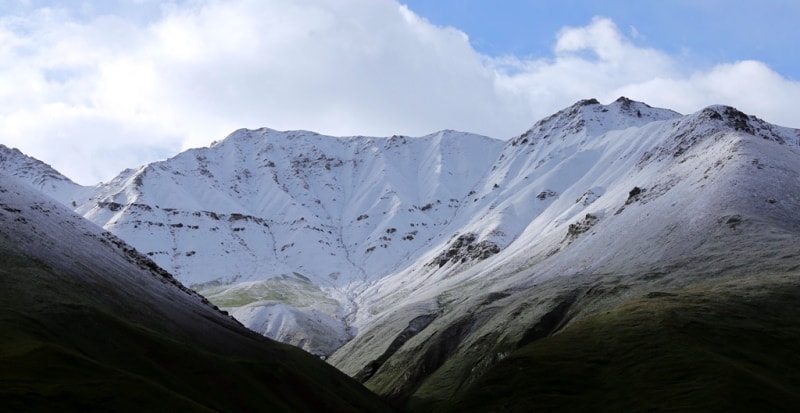
The axial ridge of the Western Tien Shan is the latitudinal ridge Talasskiy Alatau, which has a narrow and rocky ridge. The heights of the ridge at the top of Manas reach 4488 meters above sea level. The ridge serves as a watershed for the basins of the Talas and Chirchik rivers.
On the northern, relatively short and steep slope, the Talas Alatau faces the valley of the Talas River, which flows parallel to the ridge. Several spurs depart from the western part of the southern slope of the ridge in the southwest direction: the Ugamskiy, Pskemskiy, Chandalashskiy, Chatkalskiy ridges, from which the Kuraminskiy ridge branches off in the upper reaches of the Angren River.
To the northwest of the Talas Alatau are the Boroldai Tau mountains, north of which the Karatau ridge begins, reaching an altitude of 2176 meters above sea level. The ridge stretches far to the northwest, bordering Muyunkum from the south.
The spurs of the Talas Alatau are strongly dissected by deep valleys of numerous rivers belonging to the Chirchik and Angren basins, the height of the ridges is about 4000 meters above sea level, and in some peaks even higher.
The most powerful and highest ridge is the Chatkal ridge with a dominant height of 4503 meters above sea level. The ridge in the central and northeastern parts is strongly dissected into a series of peaked peaks; in the southwestern part it has a soft, rounded outline.
The Angren plateau adjoins this part of the ridge, into which deep canyon-like valleys of the upper reaches of the Angren are cut. In the highest parts of the ridges, there are minor glaciers and snowfields. To the south of the Western Tien-Shan and the Fergana ridge is the Fergana Valley, which is the largest intermountain depression.
It is stretched in the latitudinal direction for more than 300 km. Ranges Alaysky, Turkestansky in the south, Chatkalsky with Kuraminsky in the north-west, Fergana in the north-east frame the Fergana Valley. In the western part, the valley narrows and through the narrow Khojent gates communicates with the Hungry Steppe.
The bottom of the valley decreases from east to west from 1000 meters above sea level (Osh city) to 320 meters above sea level (Khujand city, former Leninabad). The bottom is separated from the foothills of the surrounding ridges by a strip of conglomerate adyrs, which are low hills with a gently convex or almost flat summit surface.
Their relative height is up to 100 - 400 meters above sea level. The Chatkal ridge has large spurs - Sargardon, Kumbel and Kuraminsky, the Koksuisky ridge departs from the Pskemsky ridge, and the Korzhantau mountains from the Ugamsky ridge.
The orographic basis of the region is the Talas Alatau, which separates the basins of the Talas and Chirchik rivers. The narrow rocky ridge of the ridge has a latitudinal strike. The southern slope is not clearly expressed, since a number of powerful spurs depart from it in the south-western direction, of which the largest is the Chatkal ridge.
This ridge separates the Chirchik basin from the rivers originating on the southeastern slopes of the Chatkal mountains, The high Angren plateau adjoins the southwestern outskirts of the Chatkal ridge, over which the Kuraminsky ridge rises, resembling the southwestern part of the Chatkal ridge.
Almost parallel to the Chatkal ridge, the Chandalash, Pskemsky, Maidantal and Ugamsky ridges depart from the Talas Alatau, also in the southwestern direction. From their the slopes flow down numerous rivers that feed the main waterways of the Western Tien Shan - Chatkal and Pskem.
Geology of Western Tien-Shan.
The main mountain-building movements in the Talas Alatau and in the northeastern part of Karatau took place in the Caledonian time. They are characterized by the development of Proterozoic and Lower Paleozoic rocks, broken by granitoid intrusions, which, due to a long period of continental denudation, are brought to the surface.
In the western spurs of the Talas Alatau, Hercynian orogenesis manifested itself. Sedimentary strata of the Middle, smaller than the Upper Paleozoic, as well as effusive rocks are widely developed here. The ridges are composed mainly of limestone, sandstone, shale, etc.
During the Mesozoic, in the platform areas of Central Asia, oscillatory movements of an epeirogenic nature took place, causing a change in the continental and marine regimes. During the Cretaceous and Daleogene, shallow seas entered the Western Tien-Shan, leaving clay and sandy sediments here, and also abraded denudation plains (Angren plateau, etc.).
Continental deposits are represented by detrital rocks. In the Quaternary, there was a significant uplift of the ridges surrounding the Fergana Basin.
Rivers of the Western Tien-Shan.
Chatkal, the main component of Chirchik, begins at the junction of the Talas and Chatkal ranges and in the upper reaches it passes through a wide ancient glacial valley. Having accepted a large tributary Sandalash (Chandalash) on the right, Chatkal becomes abundant, and after the confluence of the Ters River on the left, it flows in a gorge and near the village of Burchmulla pours its waters into the Charvak reservoir.
The second component of Chirchik, the Pskem River, begins in the glaciers and snowfields of the Talas Alatau. Its sources are Maidaital and Oygaing, after the confluence of which it flows in a narrow gorge through numerous rapids.
In the area of the Charvak reservoir, Chatkal and Pskem merge, forming the Chirchik - the most abundant tributary of the Syr Darya. The Ugam River, the largest right tributary of the Chirchik, flows into it below the Charvak hydroelectric power station.
Ugam feeds on springs and streams that run down the slopes of the Ugam ridge and its spur Korzhantau. The Akhangaran (Angren) river is also formed from streams starting on the southern slopes of the Chatkal ridge.
In the upper and middle reaches, it cuts through the Angren plateau with a deep canyon. Here the river receives a number of right tributaries, which in their upper reaches have formed narrow gorges, on the plateau they have the character of flat rivers, and before flowing into Akhangaran they rush down with beautiful waterfalls.
On the southeastern slopes of the Chatkal ridge, many rivers flow into the Fergana Valley, but often do not reach the Syr Darya, because they are dismantled for irrigation. The largest of these rivers are Karasu, Kasansay, Gava.
The Syr-Darya river, formed in the eastern part of the valley by the confluence of the Naryn and Karadarya rivers, flows to the west, along the northern edge of the valley. When crossing the spur of the Turkestan ridge, the Mogoltau forms the famous Begovatsky rapids.
After leaving the basin, the Syr-Darya turns to the northwest. To the south of the Syr Darya, within the depression on the flat surface of the bottom, composed of loesslike loams, hilly sands, takyrs, and blinders are developed.
Western Tien Shan is not rich in lakes. The most famous of them is Sarychelek. Small-sized dammed or moraine lakes are located in the gorges of the tributaries of the main rivers of the region.
Climate of Western Tien Shan is also continental.
The dismemberment of the relief of the Western Tien Shan also gave rise to climatic differences, depending on the absolute height of the area, the relief of this area and exposure. The Talas Valley is cool and dry. In the Pskem valley, the climate is warm, mild, with an abundance of atmospheric precipitation: the mountains protect it from cold northern winds, but do not interfere with the circulation of warm and humid air from the west,
In the huge Chatkal valley, the climate is more severe, while on the slopes of the Chatkal ridge facing the Fergana Valley, thermophilic tobacco, corn, and fruit trees are grown. The hottest month in the Western Tien Shan is July, when the air often warms up to 40 °, although the average monthly temperature is almost twice as low.
The absolute minimum reaches minus 30 °, in some places and minus 40 °. The frost-free period in most of the Western Tien Shan lasts less than 200 days. The amount of precipitation in winter exceeds 200 mm, and in the upper reaches of the Pskem reaches 1200 mm.
In the spring and summer During the period, there is especially a lot of precipitation (up to 65 mm) in March-April, the smallest amount is in July. Snow lies from November to March. The amount of water in the rivers that form their runoff in the lower part of the mountain ranges depends on the height of the snow cover.
Very often, such rivers have only a temporary flow - during the period of snow melting and the passage of rains. Average July temperatures here are +19, + 20 °, and the absolute maximums reach +30, + 40 °. In January, in the lower parts of the mountains, temperatures range from -3 to -8 °, in the high-mountain belt they reach -15, - 20 °.
The absolute minimum reaches -40 °. Due to the fact that the spurs of the Talas Alatau are located on the periphery of the mountainous region and are favorably oriented towards the main moisture-bearing air masses, their windward slopes receive 500 - 600 mm of precipitation per year.
Maximum precipitation occurs in March - April. The most abundant rivers of the Western Tien Shan are Chirchik, Angren and Karadarya, belonging to the Syr Darya basin.
Soils and vegetation of the Western Tien-Shan.
On the plains adjacent to the western Tien Shan, light gray soils are developed, which are saline in places. The vegetation is represented by an ephemeral formation, the main components of which are bulbous bluegrass (Poa pulbosa var. Vivipara) and narrow-leaved sedge (Carex pachystylis). In some places they also occupy the overlying slopes of the foothills.
Above, in the range of heights from 300 - 400 to 600 - 700 and from 600 - 700 to 1000 - 1200 meters above sea level, common gray soils, mainly on loesses, and dark gray soils are common. The vegetation is represented by sedge-bluegrass with the participation of large grasses.
At altitudes from 1000 - 1200 to 1400 meters above sea level, leached gray soils, or, as they are called, dark gray soils of subtropical steppes, are widespread. The vegetation is wheatgrass-forb, dominated by hairy wheatgrass (Agropyrum trichophorum), bulbous barley, etc. In the northern parts, these soils are replaced by mountainous light chestnut soils.
Wormwood-feather-grass-fescue steppes are developed on them, in which the background is formed by feather grass (Stipa capillata) and fescue (Festuca sulcata). On rough soils, wormwood is mixed with them. The steppes are found in sections in the Talas Alatau.
From an altitude of 1200 - 1500 and up to 2300 meters above sea level, mountain-forest brown soils are developed under broad-leaved forests, which are distributed in separate massifs among meadow steppes, wild rose thickets.
Walnut forests (Juglans regia) grow on the southern slope of the Chatkal ridge, as well as the Ugamsky and Psemsky, which are protected from cold invasions by mountain ranges. Companions of the nut are: maple, apple, cherry plum, buckthorn.
A large role in the landscape of this belt is played by: rose hips (Bosa Esae), prickly almonds (Amygdalus spinosissima), cotoneaster, honeysuckle, exochord, etc. In the upper belt of this zone, starting from an altitude of 2300 - 2400 meters above sea level, coniferous forests grow from the Tien-Shan spruce, to which in the Talas and Chatkal ridges the Semenov fir (Abies Semenovi) is mixed in places).
In the southern regions of the Western Tien Shan, within this belt, juniper forests are widespread, which occupy heights from 1900 - 2000 to 2200, and sometimes up to 3000 meters above sea level. Thickets of juniper (Juniperus talassis) are found in the Talas Alatau. In the drier Kuraminsky ridge, there are no walnut and spruce forests. Junipers in combination with steppes are widespread here.
Mountain-meadow-steppe brown soils are developed in the subalpine belt.
The vegetation cover is represented by medium-grass vegetation (battering ram, yugan, etc.). On the Chatkal and Kuramin ranges, this belt is formed by fescue steppes and thorny dwarf shrubs. In the alpine zone, low-grass meadow vegetation grows on mountain-meadow semi-turfy soils.
Flora of Western Tien-Shan.
Already the first researchers of the Western Tien Shan noticed the vertical zoning of the distribution of flora and fauna in this area. In the foothill and mid-mountainous parts of the Talas Valley, there is a belt of steppes, higher - meadow steppes, less often - meadows.
On the slopes of the Talas Alatau there are wild goats, marmots, stone partridges, high in the mountains - mountain turkeys - ulars. The southeastern slopes of the Chatkal ridge are occupied by forb steppes, subalpine and alpine meadows used for pastures.
Among the steppe and meadow areas, walnut forests grow along river valleys and mountain slopes. In the forests of Prichatkalye, you can find walnuts, wild apple trees, plums, Tien Shan spruce, fir, juniper. The fauna of mountain forests is very rich.
There are wild boars, porcupines, bears, stone martens, marmots, forest dormouse, thousands of different birds. On the floodplains of Chatkal and its numerous tributaries, there are forests of birch, willow, poplar, thickets of wild rose, honeysuckle, sea buckthorn, black currant.
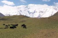
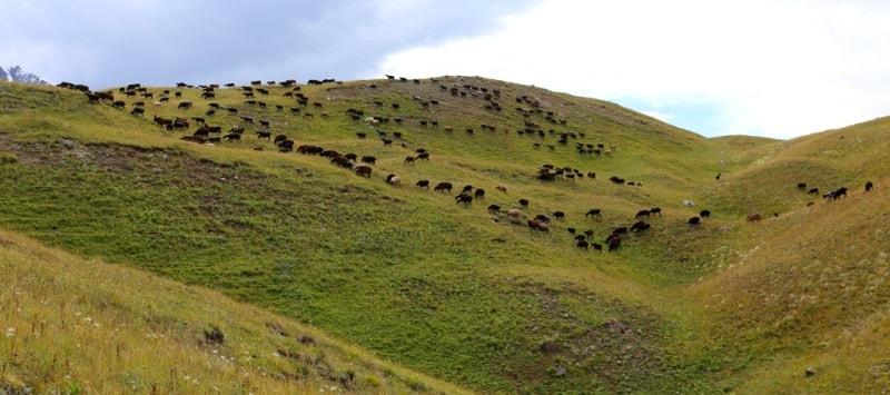
The Chatkal valley is a large cattle-breeding area of great importance for the development of animal husbandry in Kazakhstan, Kyrgyzstan and Uzbekistan. The mid-mountain belt of the Akhangaran valley is a forest region, where there is a lot of juniper, maple, hawthorn, in the side gorges you can find apple, cherry-plum, and mountain ash.
Scientists believe that previously the mountain slopes of this valley were completely covered with woody vegetation, which was eventually destroyed. Cutting down trees and shrubs is now completely prohibited. In the intermontane valleys of the lower reaches of Chatkal, along the Koks and Pskem, there are thickets of thaw, birch, poplar, tamarisk bushes, honeysuckle, rose hips, sea buckthorn, wild grapes, blackberries.
Below, in the area of the confluence of Chatkal and Pskem, there are many fruit trees: apple, apricot, cherry plum, pear. The mountain slopes are covered with thickets and separate groves of walnut, maple, poplar.
There are three large reserves on the territory of the Western Tien Shan: Aksu-Dzhabaglinsky, Sary-Cheleksky and Chatkalsky.
Archeology of the Western Tien-Shan.
The isolated position of the Western Tien Shan, especially the upper reaches of the Chirchik, served as the fact that even a century ago there was very little information about it. This area, which lay aside from the large caravan routes, was a kind of dead end, which was always bypassed by both conquerors and travelers.
It is not surprising that we almost never find mentions of the Western Tien Shan among the ancient geographers, who, meanwhile, wrote about the cities of the Fergana and Talas valleys. As established, the main occupation of the ancient inhabitants of the Western Tien Shan was hunting.
This, in particular, is evidenced by the numerous rock carvings of ancient man, depicting various animals. Such drawings were found on the territory of Aksu-Dzhabaglinsky and Chatkalsky reserves, near the village of Khodjikent, on the slopes of the Big Chimgan summit.
Large settlements were usually located in the foothill part. So, in ancient times there was a large city of Isfidjab, which was named Sairam (Turkestan region) in the Xth century. The excavations of ancient miners in the Akhangarapa valley are attributed by archaeologists to the Xth - XIIth centuries.
Around the same time, cities arose, the ruins of which are found in the Talas valley. A remarkable architectural monument of the XIII century, the Shah-Fazil mausoleum, is located in the Kasansay valley.
History of studies of Western Tien-Shan.
Scientific study of the Western Tien Shan began at the end of the XIXth century, after the annexation of Turkestan to Russia. The first Russian scientist to penetrate the upper reaches of the Chatkal was the zoologist and geographer N. A. Severtsov.
In 1866 he crossed the Talas Alatau through the Karabura pass and explored the upper part of the Chatkal valley. In 1874, the geologist and geographer IV Mushketov began his travels across Central Asia. He crossed several Korzhantau mountains, crossed from the Pskem valley to Chatkal then to Talas, explored the southern slopes of the Chatkal ridge and the upper reaches of the Angren. Five years later, another geologist, D. L. Ivanov, discovered glaciers in the Pskem valley.
Among the pre-revolutionary researchers of the Western Tien Shan, one can also name B. A. Fedchenko, V. I. Lipsky, O. A. Shkapsky. However, then travels and expeditions in the Western Tien Shan were deprived of a system, reflecting the personal desires and tastes of scientists. And most importantly, many studies were so short-lived and fleeting that scientists sometimes limited themselves to only cursory observations.
After the October Revolution, the study of the Western Tien Shan changed radically. The Turkestan (now Tashkent) State University, founded in 1920, carried out an enormous amount of work to study the region. In the first years of Soviet power, geologists, botanists, zoologists, and hydrologists began to work regularly in the mountains.
At that time, for example, special expeditions were created to organize the reserves of Aksu-Dzhabaglinsky and Sary-Cheleksky, searches for minerals were carried out on the southern slopes of the Chatkal mountains, in the Akhangaran valley, in the upper reaches of the Chirchik, in the foothills of the Talas Alatau.
Now the mountains of the Western Tien Shan serve people. On their slopes thousands of flocks of sheep graze, various varieties of valuable fruit crops are grown, hundreds of health institutions are being built. Powerful hydroelectric power stations and artificial seas are being created on the rivers, for example, the Charvak and Kasansay reservoirs.
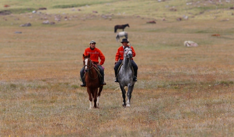
Following the researchers, attracted favorable climatic conditions, the townspeople went to the mountains to rest. Tourism in the mountains of the Western Tien Shan. Over time, there were more and more mountain travel enthusiasts, and at the end of the 50s, the first tourist center in Uzbekistan appeared in the vicinity of Chimgan.
Western Tien Shan, located on the territory of Kazakhstan, Kyrgyzstan and Uzbekistan, is convenient for travel by numerous access roads. Dirt roads approach almost all gorges of the northern slope of the Talas Alatau, and along the Karabur gorge, the road through the pass of the same name leads to the Chatkal valley, where there are branches into the gorges of the side tributaries.
The same road from Chatkal goes to the Fergana Valley through the Chapchama pass, having many routes to the Kasansay tributaries. There are also roads in the river valleys descending into the Fergana Basin.
A good road runs along the Angren Valley before climbing the Kamchik Pass. There are many entrances to the mountains in the area of the Chatkal mountain-forest reserve, at the confluence of Chatkal and Pskem. From here, dirt roads lead to the middle part of the Pskem valley and up Chatkal.
Ugam is accessible for vehicles in the lowest part, in the middle reaches, where a dirt road passes through the Korzhantau mountains near the Kyrkkyz pass. The same roads are laid in the vicinity of the Aksu-Dzhabaglinsky nature reserve and in the western part of the Talas Alatau.
Wild boar, roe deer, forest dormouse, forest mouse, porcupine are found among the animals in the forests of the Western Tien-Shan; from birds - dove, klintukh, blackbird, oriole, etc. Dry and irrigated agriculture is developed within the Western Tien-Shan.
The Tien-Shan mountains are rich in minerals. Here are mined: polymetals, coal, oil, chemical and cement raw materials. The energy of mountain rivers is used to create hydroelectric power plants.
Geographic coordinates of Western Tien Shan mountains: N41 ° 56'57.86 "E70 ° 53'50.04"
Authority:
Popov V.N. "Western Tien Shan". M., "Physical Culture and Sports", 1978.
Photos by
Alexander Petrov.