You are here
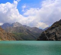
Lower Lake Alamedin.

Walking along gorges of Kyrgyz Ala-Too.
“The water is delicious in the mountains, the flowers are beautiful on the plain”
Chinese proverb.
Tourist routes in Alamedin gorge.
The lower Alamedin Lake is located at an altitude of 3067 meters above sea level, located on the right, western slope of the Alamedin gorge, on the northern slope of the Kyrgyz Ala-Too ridge in the Alamudun district of the Chui region.
4 kilometers after its source, the Ashutor river flows into the Lower Lake Alamedin. The lake has a rocker-like shape and is located in the middle part of the Ashutor River. In the northeast, behind the crest of the meridional ridge, there is the Pastukhov Glacier, which belongs to the Alamedin River basin.
Half of the way from Lake North Alamedin, the river flows in underground labyrinths and shortly before the Lower Lake appears on the surface. The length of the Lower Lake is 226 meters, the width in the central part of the lake is 40 meters.
The perimeter of the lake reaches 503 meters, the area is 6441 square meters. The Ashutor river flows into the lake from the southeast, passing through the lake, the river flows out of it in the northern part. The lake is located in a narrow gorge that stretches from the south-east to the north-west.
A trail runs along the talus western part of the lake.
Geographic coordinates of the Lower Alamedin Lake: N42 ° 27'18.78 "E74 ° 41'34.15"
Authority and photos by
Alexander Petrov.


