You are here
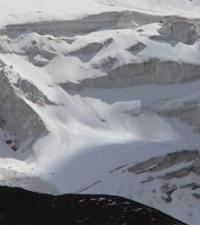
Traube Glacier.

Mountain hiking in Pamir mountains.
“Walter and I had a great honor. Nikolai Vasilyevich named 2 glaciers descending from Stalin Peak after our names! The northwestern one, between Stalin and Moskvin Peak, is mine, the “Traube Glacier”. And the north-eastern one, between Stalin Peak and Vorobyov Peak, is the “Walter Glacier”.
"Pamir Expeditions" August 28, 1933. P. A. Traube.
Trip to Pamirs.
Upper limit of Traube glacier is located at an altitude of: 6372 meters (Kirov peak) meters above sea level, 6016 meters above sea level, 5203 meters above sea level, end of glacier is located at an altitude of 3759 meters above sea level, located on northern slope of Pamir firn plateau, on northern slope of Peter Great ridge, in Lakhsh region of Republic of Tajikistan.
The Traube Glacier originates from the northern slopes of the Pamir firn plateau, located in turn on the northern slopes of the Peter the Great ridge. After the “Borodkin Rib”, a large tributary is added to the Walter glacier, formed by the ice of the northeastern slopes of Kirov Peak.
This tributary was named the Traube glacier in 1933 (in the “Catalog of Glaciers of the USSR”, it is not distinguished as an independent one). The length of the Traube glacier is 8.7 kilometers, its area reaches 9.06 square kilometers, and the perimeter of the glacier is 20.14 kilometers.
A 2.1-kilometer-long river flows out of the glacier, which, merging with the inflow from the Moskvin and Walter glaciers, belongs to the Fortambek glacier basin. At an altitude of 4456 meters above sea level, the Traube Glacier merges with the Walter Glacier.
630 meters east of the confluence of the Moskvina and Walter and Traube glaciers, from July to the end of August there is a mountaineering camp in the Moskvina glade (Suloev glade).
Geographic coordinates of Traube glacier: N38°58'57 E71°57'55
Authority:
Alexander Petrov.
"Fortambek and its peaks." G. Kalinin. Tashkent, Uzbekistan, 1983.
Photos by:
Alexander Petrov.


