


![]()
You are here
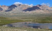
Lake Arabel.
Guide to mountain routes in Terskey Ala-Too mountains.
"At the pass, the glacier, branching to the right and left, rises to the peaks. Ahead, in the east, as far as the eye can see in the direction of the dark lake, the plain turns blue, and behind it the Ak-Shyyrak ridge is visible, here and there snowy peaks appear."
Ella Maillart. "Turkestan Solo". 1932.
Description of tourist routes in Terskey Ala-Too.
Flowing, fresh, moraine lake Arabel is located at an altitude of 3766.3 meters above sea level, is located on southern slope of Terskey Ala-Too ridge, in upper reaches of river of same name, 7.9 kilometers southeast of Dzhukuchak pass at an altitude of 4042 meters above sea level, 9.3 kilometers northwest of moraine lake Petrov in Jety-Oguz district of Issyk-Kul region.
Moraine lake Arabel, the pearl of the southern slope of Terskey Ala-Too. The lake was formed as a result of the melting of glaciers and the subsequent accumulation of water in a trough basin formed by moraine deposits. The lake is located high in the mountains, which makes it one of the most inaccessible reservoirs in the region.
t is located in the Arabel valley, which is known for its harsh climate and extensive glacial fields. The area around the lake is characterized by picturesque landscapes, represented by mountain ranges, alpine meadows and glaciers. Like other moraine lakes, Arabel was formed as a result of the activity of glaciers, which, retreating, left behind a natural dam of stones, soil and ice.
These deposits prevent the free flow of water, forming the lake bowl. The water in the lake is usually icy even in summer, and its depth can vary significantly depending on the season and the activity of glacial melting. Lake Arabel is located in the north-eastern part of the high-mountain valley Arabel, which stretches from the southwest to the northeast for 47 kilometers.
The lake is located in the Dzhukuchak valley and consists of three parts: the central part of the lake is connected by a riverbed and channels with the northern part of the lake. The lower, southern lake is located 280 meters from the central lake.
A 428-meter-long stream flows from the southern Arabel Lake, which flows from the right into the Arabel River. From the north side, a river flows into Lake Arabel, which flows down from the southern slopes of the Terskey Ala-Too ridge. In the interval from the sources from the glaciers and to the confluence with Lake Arabel, the river is called Dzhukuchak Yuzhnaya, 8.1 kilometers long.
After 4.4 kilometers from the beginning of the sources from the small Dzhukuchak Zapadny glacier, which is located on the southern slope from the Dzhukuchak pass, the river receives a tributary from the left, which flows from the Dzhukuchak eastern glacier.
After 6.3 kilometers, the river reaches a trough valley formed by the work of ancient glaciers, where more than 20 large and small moraine lakes are concentrated. The length of the valley is 1.2 kilometers, the greatest width reaches 452 meters.
The length of Lake Arabel from north to south is 2.1 kilometers, the greatest width in the central part is 1.4 kilometers. The area of the lake is 1.26 square kilometers, the length of the coastline is 7.55 kilometers. The length of Lake Yuzhnoye Arabel from northwest to southeast is 847 meters, the greatest width in the central part is 360 meters.
The area of the lake is 0.23 square kilometers, the length of the coastline is 2.08 kilometers. Due to the harsh climate, the flora in the lake area is represented mainly by low-growing plants characteristic of alpine and nival zones. Mosses, lichens and small shrubs are found here.
The fauna is also sparse: you can meet mountain goats, marmots, and golden eagles and other birds of prey soar in the sky. The moraine lake Arabel is an object of interest for climbers, mountain tourists and extreme tourism enthusiasts. The path to it runs through difficult mountain routes that require physical fitness and experience in overcoming highlands.
However, those who get to the lake get a unique opportunity to enjoy untouched nature and breathtaking views of the snowy peaks of Terskey Ala-Too. The lake plays an important role in the hydrological system of the region, as it is a natural reservoir of fresh water. In addition, it serves as an indicator of climate change: fluctuations in water levels and glacier transformations may indicate global climate change.
The moraine lake Arabel is a unique natural object that attracts researchers and travelers with its beauty and mystery. Despite its inaccessibility, it continues to be an important part of the Central Tien-Shan ecosystem and is one of the most picturesque places on the southern slope of Terskey Ala-Too.
Geographic coordinates of Lake Arabel: N41°57'35 E78°08'47
Authority and photos by:
Alexander Petrov.