


![]()
You are here
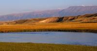
Kumtor River.
Best natural attractions of Kyrgyzstan.
"Past the Kolpakovsky glacier, which remained on the right in a side valley, we climbed a flat pass overgrown with sedge bordering the syrts and on August 3 came to the source of the Kumtor River (Taragai-aryn), originating from the Petrov glacier."
V.V. Sapozhnikov. "Explorations in Naryn River Valley." 1913.
Tourist guide to Mountains of Kyrgyzstan.
Kumtor River originates from eastern part of high-mountain syrts of Arabel Valley, located between western spurs of Ak-Shyirak ridge and southern slopes of Terskey Ala-Too ridge on Arabel-Su at an altitude of 3813 meters above sea level, is located in Jety-Oguz district of Issyk-Kul region.
The Kumtor River, one of the picturesque and significant tributaries of the Naryn River, a river originating in the highlands of the Tien-Shan, plays an important role in the region's ecosystem and is part of the water basin that feeds the Naryn River, the largest in Central Asia, which in turn gives rise to the Syr Darya River.
Along the Kumtor River, one can observe typical high-mountain landscapes: rocky slopes, alpine meadows and glacial moraines.
Kumtor River basin consists of the main full-flowing rivers: the left tributaries are Akbel, Bordu, Bordu Yuzhny, Bordu Severny, Sarytor Yuzhny, Sarytor Severny, the right tributaries are the Arabel River. The sources of the Kumtor River, 32.5 kilometers long, are located on the western slope of the Akshirak ridge.
The river receives its main source from Lake Petrov, located at an altitude of 3,730 meters above sea level. The main riverbed is formed at an altitude of 3625 meters above sea level, almost 9 kilometers west of Lake Petrov, where the Arabel River flows in from the right.
The lake is filled from two glaciers: the Western Petrov glacier, 11 kilometers long, and the Eastern Petrov glacier, 13.6 kilometers long. The highest point of the Western Petrov glacier is located in the main ridge of the Akshirak ridge at an altitude of 4916 meters above sea level.
The highest point of the Eastern Petrov glacier is located in the main ridge of the Akshirak ridge at an altitude of 5100 meters above sea level. At 4 kilometers after the sources, the river receives the Lysy tributary on the left, which flows out of the glacier of the same name.
At 9 kilometers after the sources, the river flows through the economic part of the Kyrgyz Kumtor mine. At the 13th kilometer, the Sarytor tributary flows into the river from the left, which originates from two glaciers: the Sarytor West, 3.9 kilometers long, and the Sarytor East, 3.6 kilometers long.
At the 18th kilometer after the sources, the Kumtor receives the Bordu Severny tributary from the right, at the 24th kilometer the river receives the Bordu Yuzhny tributary from the left and here the Akbel tributary joins. The mouth of the river is located at an altitude of 3346.3 meters above sea level.
Like many mountain rivers, the Kumtor is subject to the influence of climate change, which can lead to the reduction of glaciers and changes in the water regime. In addition, anthropogenic impact associated with mining activities in the upper reaches of the river requires careful attention to the ecological state of the river.
To preserve the river, it is important to monitor its condition and minimize the negative impact on the environment. The Kumtor River is not only an important tributary of the Naryn, but also part of the unique nature of the Tien-Shan. Its fast waters, picturesque banks and connection with the glaciers of the Ak-Shyirak ridge make it one of the pearls of mountainous Kyrgyzstan. Preservation of this river is a concern for the future of the region and its natural heritage.
Geographic coordinates of Kumtor River: N41 ° 47'36 E78 ° 02'36
Glaciers of the Kumtor River basin are located on western slope of Ak-Shyirak ridge.
Akbel Glacier.
From the southernmost Akbel glacier in the western spur of the Ak-Shyirak ridge, 1.3 kilometers long, the width of the glacier reaches 4.1 kilometers, the exposition of the glacier is located from south to north in a narrow gorge, stretched from east to west.
From the western part of the glacier flows the Akbel River, 11.1 kilometers long, is a left tributary of the Kumtor River. The upper boundary of the glacier is at an altitude of 4465 meters above sea level, the tongue of the glacier is at an altitude of 3958 meters above sea level.
Geographical coordinates of Akbel glacier: N41°44'32 E78°08'56
Maly Kazan Glacier.
The next glacier is Maly Kazan, consisting of two parts: northern and southern, the length of the northern part of the glacier is 1 kilometer, the length of the southern part of the glacier is 870 meters. The Maly Kazan River, 3.2 kilometers long, originates from the glaciers, which is a right tributary of the Akbel River. The upper boundary of the glacier lies at an altitude of 4511 meters above sea level, the tongue of the glacier is at an altitude of 4023 meters above sea level.
Geographic coordinates of Maly Kazan glacier: N41 ° 45'17 E78 ° 09'04
Bolshoy Kazan Glacier.
To the north of the Maly Kazan glacier is the extended Bolshoy Kazan glacier, 2.2 kilometers long. The glacier is located on the southwestern slope of the western spur of the Akshirak ridge. The upper boundary of the glacier lies at an altitude of 4662 meters above sea level, the tongue of the glacier is at an altitude of 4029 meters above sea level.
Geographic coordinates of Bolshoy Kazan Glacier: N41°46'10 E78°09'45
Bordu Glacier.
Following the Bolshoy Kazan Glacier further north is the Bordu North and South Glacier Group. The complex Bordu South Glacier is 4.5 kilometers long, the greatest width of the glacier in the upper part is 3 kilometers. The Bordu South River, 9.2 kilometers long, flows out of the glacier, which flows into the Akbel River in its lower reaches, and then, having joined, both rivers become the left tributary of the Kumtor River.
The river, having left the gorge with the glacier, flows parallel to the Kumtor River in the southeast for 5 kilometers. In the middle reaches, the Bordu South River crosses the Dzhoudzhurek ridge. The upper boundary of the glacier lies at an altitude of 4698 meters above sea level, the tongue of the glacier is at an altitude of 3897 meters above sea level.
Geographic coordinates of Bordu South Glacier: N41°47'41 E78°09'3
Bordu North Glacier is 3.9 kilometers long, the greatest width of the glacier in the middle part is 1.7 kilometers. The Bordu North River flows from the glacier, 6.5 kilometers long, which is the left tributary of the Kumtor River. The upper boundary of the glacier lies at an altitude of 4637 meters above sea level, the tongue of the glacier is at an altitude of 3918 meters above sea level.
Geographical coordinates of Bordu South Glacier: N41°48'41 E78°10'43
Davydov South Glacier is 3.8 kilometers long, the greatest width of the glacier in the upper part is 800 meters. The Sarytor South River flows from the glacier, 6 kilometers long, which is the left tributary of the Kumtor River. The upper boundary of the glacier is at an altitude of 4946.9 (the summit of the SNK of Kyrgyzstan (Sary-Tor) meters above sea level, the tongue of the glacier is at an altitude of 3942 meters above sea level.
It should be noted that the moraine of the Davydov South glacier and the bed of the Sarytor River were developed by the technological processes of the Kyrgyz Kumtor mine.
History of Davydov Glacier.
Davydov Glacier, located on the western slope in the Ak-Shyirak ridge, was named in 1925 by the name of the head of the expedition of the Central Asian Meteorological Institute, Lev Konstantinovich Davydov (19.10.1893, Tashkent, - 12.12.1968, Leningrad), a Soviet geographer-hydrologist, Doctor of Geographical Sciences (1947). Since 1930, the director of the Central Asian Hydrometeorological Institute.
Geographical coordinates of Davydov South Glacier: N41°49'30 E78°10'38
Davydov North Glacier is 2.3 kilometers long, the greatest width of the glacier in the middle part is 2.5 kilometers. The Sarytor North River flows out of the glacier, which is the left tributary of the Kumtor River, there is no river bed. The upper boundary of the glacier lies at an altitude of 4678 meters above sea level, the tongue of the glacier is at an altitude of 4097 meters above sea level. It should be noted that the moraine of the Davydov North Glacier and the river bed were developed by the technological processes of the Kyrgyz Kumtor mine.
Geographic coordinates of Davydov North Glacier: N41°50'45 E78°12'37
Lysyi Glacier consists of two parts, the northern and southern: the length of the southern part is 2.7 kilometers, the length of the northern part of the glacier reaches 2.9 kilometers, the greatest total width of the glacier in the middle part is 2.7 kilometers.
A river 4 kilometers long flows from the glacier, which is the left tributary of the Kumtor River, there is no river bed. The upper boundary of the northern glacier lies at an altitude of 4547 meters above sea level, the tongue of the glacier is at an altitude of 4942 meters above sea level.
The upper boundary of the southern glacier lies at an altitude of 4646 meters above sea level, the tongue of the glacier is at an altitude of 3919 meters above sea level. It should be noted that the moraine of the Lysy Glacier and the river bed were developed by the technological processes of the Kyrgyz Kumtor mine.
Geographic coordinates of Bald South glacier: N41°52'08 E78°13'23
Petrov Glacier is located on northwestern slope of Ak-Shyirak ridge, largest glacier in the northeastern part of the Ak-Shyirak massif is the complex valley glacier Petrov, consisting of: Petrov East Glacier, Petrov West Glacier and Petrov North Glacier.
Geographical coordinates of Petrov Glacier: N41°54'54 E78°18'37
Authority and photos by:
Alexander Petrov.