


![]()
You are here
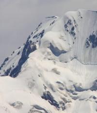
Bolgandy Glacier in Kakshaal-Too Ridge.
Glaciers of northern slope of Kakshaal-Too Ridge.
“Bad forecasts often did not come true. This is probably due to the fact that they were compiled based on information from stations located further north, and the weather in Western Kokshaal-Tau is strongly influenced by the hot deserts of Central Asia. We got the impression that the weather in this area in summer, despite its severity, is better than in the area of Pobeda Peak and the Terskey-Alatau Ridge. This was especially evident during the ascents: when the mountains in the east and north were covered with clouds, we had the sun.”
“In Western Kokshaal-Tau.” A. Korsun, P. Povarnin. 1969.
Trip to upper reaches of Eastern Aksai River.
Bolgandy Valley Glacier No. 88 is located: upper boundary of glacier is located at an altitude of 4762, 4742 (Chaynik peak) and 4818.9 m. a. s. l., tongue of glacier is located at an altitude of 3991 m. a. s. l., is located in westernmost part of Kyzyl-Asker mountain range, on northern slope in western part of Kakshaal-Too ridge in Atbashi district of Naryn region.
The glacier in the upper reaches of the eastern part borders on the Ak-Baital glacier No. 87 with a length of 5.5 kilometers, in the western part with the Bolgandybel and Chochirganak cirque glaciers with a length of 3 kilometers. The river of the same name with a length of 8.2 kilometers flows from the glacier, which is the left tributary of the Kentor River.
The length of the Bolgandy Glacier No. 88 is 5.4 kilometers, the area reaches 7.24 square kilometers, the perimeter is 16.27 kilometers, the greatest width in the upper part reaches 2.8 kilometers. The main Bolgandy Gorge divides a 5-kilometer spur stretching from the southwest to the northeast into two gorges.
In the western part of the gorge is the Bolgandy Western Glacier, 2.5 kilometers long, the area of the glacier is 2.4 square kilometers, the perimeter is 8.98 kilometers, the greatest width in the upper part reaches 2.1 kilometers. A river of the same name flows out of the glacier, 2.1 kilometers long, which is the left tributary of the Bolgandy River.
Geographic coordinates of Bolgandy Glacier No. 88: N41°02'13 E77°12'27
Geographical coordinates of Bolgandy Glacier West: N41°03'28 E77°11'48
Authority and photos by:
Alexander Petrov.