


![]()
You are here
Tour of Lake Kel-Suu and Tash-Rabat caravanserai.


An excursion toKoshay-Korgon fortification.
"I don't know where we'll meet.
You and I will have to meet.
The globe spins and turns,
Like a blue ball,
And cities and countries flash by,
Parallels and meridians,
But nowhere are there such dotted lines
Along which we can wander the world."
M. Lvovsky. "Globe." 1947.
Brief description of trip to Kel-Suu Lake in Kel-Tau Mountains:
Bishkek – Burana Tower – Kochkor village – Naryn town – Ak-Muz village – Bosogo valley – Kyndy Pass – Western Aksai River – Kokkiya River – Kel-Suu Lake – Western Aksai River – Chatyr-Kul Lake – Tash-Rabat caravanserai – Koshoi-Korgon fortification – Naryn town – Kochkor village – Boom Gorge – Bishkek.
Distance route: 1021 km.
Season: July 10th to September 1st.
Tour duration: 6 days and 5 nights.
Active tour distance: 18 km.
Best time to travel: July – August.
Detailed itinerary for excursion to Tash-Rabat caravanserai and Koshoi-Korgon fortification:
A trip from Naryn to Atbashi.
Day 1. Bishkek – Naryn (320 km).
Transfer: Bishkek – Kant – Tokmok village – Burana Tower architectural complex (72 km, 1.5 hours).
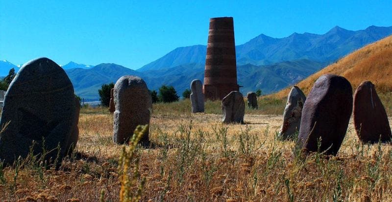
Arrival at the Burana Tower architectural and archaeological complex. In 1976, an open-air archaeological and architectural complex was established on the ruins of the Burana settlement. The complex covers 36 hectares of ancient city ruins.
Many years of painstaking research by historians and archaeologists suggest that the settlement represents the ruins of the ancient city of Balasagyn, the capital of the Karakhanid Khaganate.
Visit to the Burana Tower architectural and archaeological complex:
- Burana Museum,
- stone sculptures, balbals depicting Turkic peoples from the VIth - Xth centuries, collections of stone tools found during excavations on the territory of the Burana settlement (Xth - XIIth centuries), millstones from modern mills and threshing stones from the XVIIIh - early XXth centuries,
- petroglyphs dating from various eras - from the Bronze Age to the early Middle Ages,
- kayraks (literally "pebble", a gravestone with an epitaph),
- Burana Tower minaret. According to scientists, the tower was built in the XIth century. The tower served as a minaret and watchtower, the central ruins, where there is a mound measuring 100 x 100 meters and 10 meters high, which hides the remains of a palace complex or temple that existed here before the Xth century,
- mausoleums, Mausoleum No. 1 is located 24 meters southeast of the minaret, among Muslim graves of varying states of preservation, built at different times; Mausoleum No. 2 was located on a fairly elevated platform near the Burana River floodplain, 70 meters northeast of the "tower." End of the excursion.
Transfer: Burana Tower – Tokmok (12 km).
Lunch at a local café.
Transfer: Tokmok – Kemin town – Boom Gorge – Kok-Moinok valley – Kubakty Pass, 2,161 meters above sea level – Kochkor village – Sary-Bulak village – Dolon Pass, 3,038 meters above sea level – Kazan-Kuigan village – Naryn city (250 km).
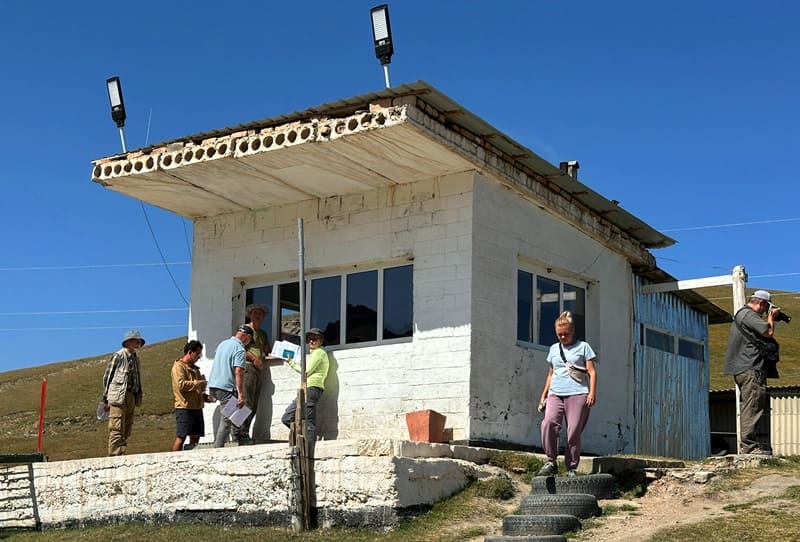
Arrival in Naryn, transfer to the hotel, check-in, dinner, overnight.
Day 2. Naryn – valley Surash-Tash – Kokkiya tent and yurt camp (135 km).
Breakfast. Transfer: Naryn – Ak-Muz village – Bosogo valley – Kyndy pass (72 km).
Our route from Naryn leads south, passing the eastern end of the Alamshyk Mountains, and soon crossing the small Chaar pass, 2,598.6 meters above sea level. From the pass, a road branches off to the large village of At-Bashi, the district center of the district of the same name, 29 kilometers away.
The pass serves as a watershed between The Naryn and At-Bashi River basins. It's worth noting that the At-Bashi River is a left tributary of the Naryn River. From the Chaar Pass, the road turns southeast, passing the southwestern spurs of the Naryn-Too Ridge, and soon begins a gentle descent into the wide At-Bashi Valley, at the beginning of which lies the village of Ak-Muz.
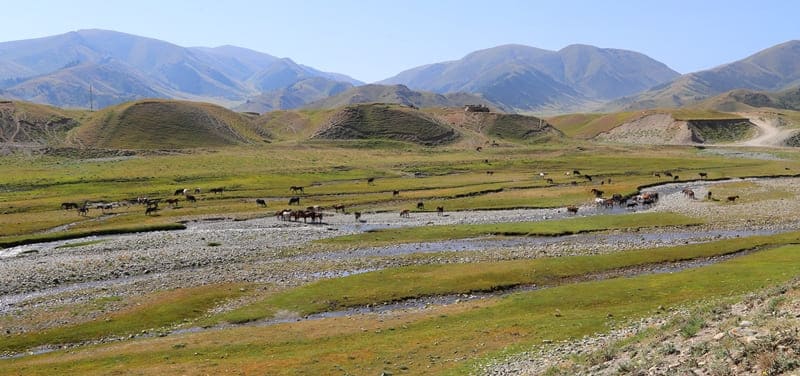
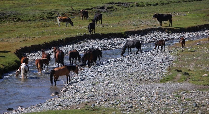
After the village, our route follows the right bank of the At-Bashi River and soon reaches the picturesque Bosogo ravine, through which the At-Bashi River flows. Numerous farms and livestock farms from the surrounding villages are located here, bringing their cattle here with the onset of summer to the lush meadows.
A short stop and a walk in the Bosogo ravine. After the ravine, the road turns south, passing the eastern slopes of the At-Bashi Ridge and the Besh-Bel-Chir Mountains. From here, the ascent begins along the Kyndy River, which lies in the western spurs of the Dzhanydzher Range, to the Kyndy Pass of the same name, at an altitude of 3,398.1 meters above sea level.
There is a border post at the pass, a stop en route to the pass, and a walk in the surrounding area. Lunch en route.
Transfer: Kyndy Pass – Kyndy River – Tyuz-Ashuu River – Western Aksai River (29 km).
From the pass, our route descends south along the Kyndy River. Soon, the road forks – one turns northeast to the upper reaches of the Eastern Aksai Valley, while the other turns south along the Tyuz-Ashuu River to the Western Aksai River. To the south rises the western part of the Kakshaal-Too Range, with the Sarybeles and Keltau mountains.
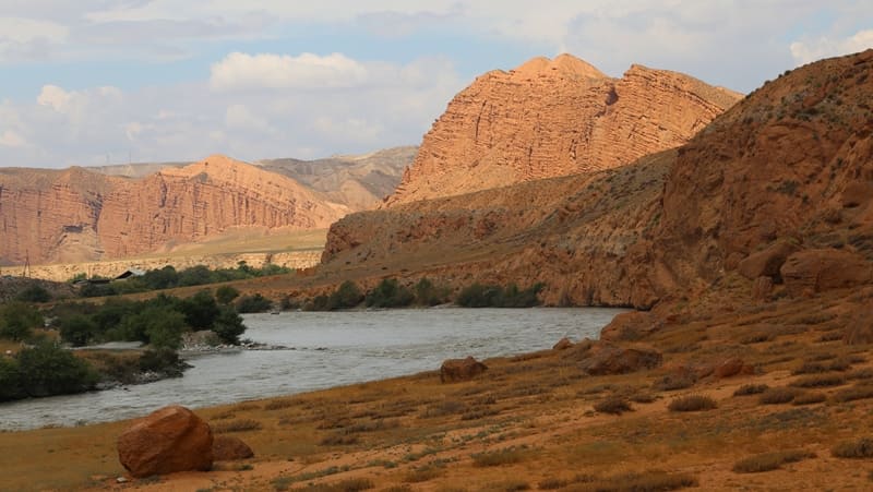
Soon we reach a bridge over the Western Aksai River. Built in 2020, the bridge is large enough for one vehicle. On the left side of the river are the remains of an old wooden bridge built in the 1950s. We stop at the bridge and stroll around the area. The river flows east and soon merges with the Modyuryum River to form the Kokshaal River.
This mighty river cuts through the western part of the Kokshaal-Too Range and flows into the Republic of China, becoming a tributary of the Tarim River.
Transfer: Western Aksai River – Kulja-Bashi River Canyon (17 km).
Soon we are on the left side of the river. From here we head west and, after 11 kilometers, turn south on a road that leads us to the picturesque Kulja-Bashi Canyon. The Bolshaya Kulja-Bashi River originates on the northern slopes of the small Sary-Beles ridge, located in the western part of the Kakshaal-Too Range, and soon becomes a right tributary of the Western Aksai River.
Over its long life, the river, with its crystal-clear and transparent water, has carved a deep canyon in the soft rock, creating fantastic, unusually colorful, bizarre forms, from residual rocks to numerous, diverse, epic stone figures. A walk in the surrounding area.
Transfer: Kulja-Bashi River – Kichin Sarybeles Pass (11 km).
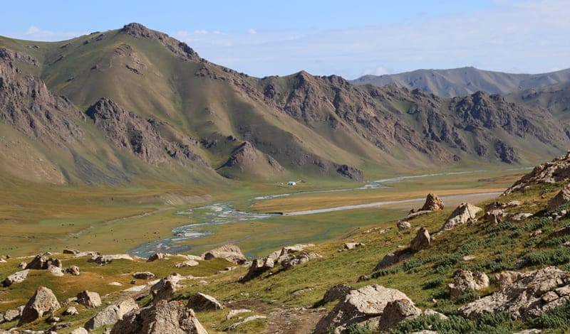
The next stage of our journey is the Kichin Sarybeles Pass, located on the northern slope of the Sary-Beles ridge and separating the valleys of the Kulja-Bashi and Kokkiya rivers. From the pass, a picturesque and vibrant view opens up of the icy and rocky peaks of the surrounding mountains. From the pass, the road leads into the Kokkiya River Valley. A walk in the surrounding area.
Transfer: Kichin Sarybeles Pass – Kokkiya River Valley (7 km).
Arrival at the Kokkiya tent and yurt camp on the banks of the Kokkiya River. Accommodation in tents, dinner, and overnight in tents or yurts.
Day 3. Kokkiya Camp – Lake Kel-Suu.
Breakfast. The campsite is located on the picturesque right bank of the Kokkiya River. A large tent and yurt camp run by Kyrgyz tour operators is located here among green meadows.
Hiking: Kokkiya Camp – Lake Kel-Suu (8 + 8 = 16 km).
Today we will hike to the high-mountain lake Kel-Suu. Lake Kel-Suu itself is difficult to reach by car, so we'll drive as much as possible and cover the rest of the way on foot or horseback.** The trail to the lake isn't difficult; we'll ford shallow rivers several times, so it's a good idea to wear rubber boots.
The walk takes about three hours each way. The 6-kilometer climb to the lake is moderate, while the remaining 2 kilometers are a gradual climb, and before reaching the lake, we'll encounter short, steep sections. The elevation difference between the camp and the lake is 200 meters.
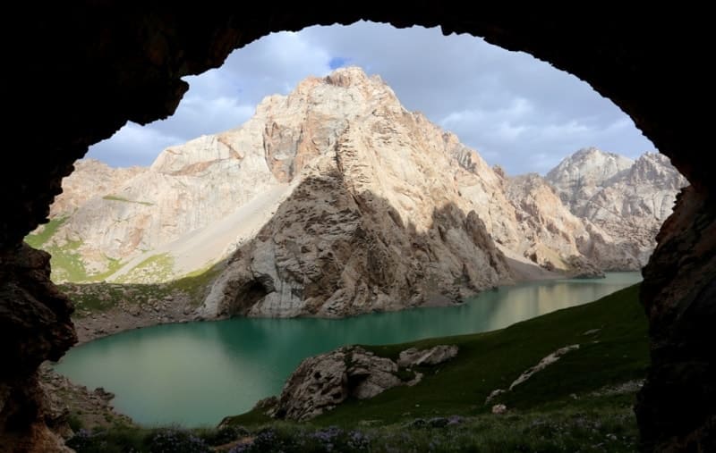
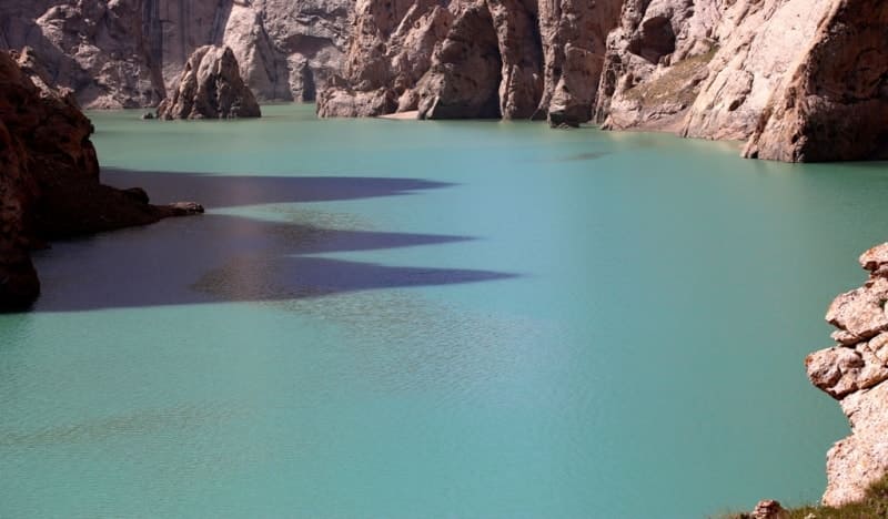
Lake Kel-Suu is one of Kyrgyzstan's most picturesque high-mountain lakes. A natural isthmus offers panoramic views of the lake, surrounded by majestic cliffs several hundred meters high, featuring waterfalls, rocky islands, bays, and various caves. The lake's waters, shimmering in turquoise, are framed by steep peaks that remain snow-covered even in summer.
The water's hue changes depending on the time of day and the angle of light. Two kilometers from the dam, deep in a sheer-walled canyon, you can see an isolated rock island about fifty meters high. These rocks have a unique topography, adorned with numerous grottoes, depressions, and small caves, creating an unforgettable natural landscape. Return to camp, dinner, and overnight in the camp.
Day 4. Kokkiya Camp - Tash-Rabat Caravanserai (215 km).
Breakfast. Transfer: Kokkiya River Valley - Lake Chatyr-Kul (122 km).
Our return journey leads to the Kuldzha-Bashi River, soon reaching the right bank of the Western Aksai River and turning west. From here, we continue along the Western Aksai River Valley. The Ak-Sai Valley stretches 163 kilometers from southwest to northeast, with its greatest width of 37 kilometers, located in the western part of the valley.
The valley extends from the border Maidantag Ridge, which in turn is located in the western part of the Kakshaal-Too Ridge, to the southern slopes of the At-Bashi Ridge in the Kensu and Chet-Ichkesu rivers. The valley's length extends from the source of the Western Ak-Su to the Kagalyachap Plateau, where the Eastern Ak-Sai River originates.
Along our route, we ford the rivers of the right tributaries of the Western Aksai: the Tekelik and Kyzyl-Su, and the large Terek River, whose upper reaches are home to the Terek Pass, which from the 18th to the early 20th centuries served as a link on the Silk Road with the Chinese cities of Artush and Kashgar.
The Western Aksai River valley is bounded in the north by the latitudinal Atbashi Range and in the south by the western spurs of the Kokshaal-Too Range. From the Terek River to the left tributary of the Kensu River, the route follows the bed of the Western Aksu River, which in this section spreads out into a wide valley.
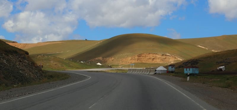
From the Kek-Aygyr valley, the road heads toward the eastern end of Lake Chatyr-Kul. Soon we'll reach the newly constructed Torugart-Naryn-Bashkek asphalt road, completed in 2015. Construction of this road for carriages and tarantasses began back in 1872. From here, it's only 6 kilometers to the Torugart Pass, 3,752.2 meters above sea level, which remains just south.
Customs buildings surround it. Lunch en route. En route, we'll visit a mineral spring located 560 meters from the road in the southeastern part of the lake. This area is home to numerous underground mineral springs, part of the Chatyr-Kul thermal mineral water deposit.
The water, similar in taste to Narzan, is popular with locals and tourists alike for its healing properties. The distance from the spring to the shore of Lake Chatyr-Kul is 2.8 kilometers. There is no road, and the area is heavily swamped and impassable. A walk by the springs.
Transfer: Lake Chatyr-Kul – Tuzbel Pass (3,574.9 meters above sea level) – Akbeit Pass (3,282.5 meters above sea level) – Tash-Rabat Gorge and Caravanserai (93 km).
Our route from the southern shore of Lake Chatyr-Kul heads west, past Tuzbel Pass, and gradually turns north. We skirt the western part of the At-Bashi Ridge with the Korgon-Tash Spur and gradually head northeast. Soon we pass the Akbeit Pass, reach the small Karabulak River, and turn right into the Tash-Rabat Gorge. Arrival at the Tash-Rabat valley, check into a tent camp, dinner, and overnight.
Day 5. Tash-Rabat – Naryn (118 km).
Breakfast. After breakfast, visit the Tash-Rabat caravanserai. Tash-Rabat is half built into a hill. The main facade stands entirely on a raised platform, while the side facades extend diagonally into the gorge slope. Tash-Rabat is the only surviving structure in Central Asia constructed entirely of broken stone, laid with clay mortar, and sealed with ganch (alabaster) mortar.
The main (eastern) facade of the monument is a wall flanked at the corners by minaret-shaped columns. The entrance, fashioned as a portal, is a monumental volume with two rectangular pylons and an arched niche in the center. Tash-Rabat is one of the rare stone structures in Central Asia.
After excursion, transfer: Tash-Rabat – Kara-Suu village – Koshoi-Korgon fortification (60 km).
Lunch at a café. After lunch, visit the fortification and the Koshoi-Korgon museum complex. The fortification is the remains of a fortress town that existed on a caravan trade route between the 7th and Xth centuries, housing the headquarters of the Turkic khans.
The structure, square in plan, with adobe walls enclosing a large area, is identified as "korgon" (translated from Kyrgyz as "fortress"). The southern and northern walls extend 283 meters, the eastern 287 meters, and the western 289 meters. The fortification covers an area of 0.09 square kilometers, with a perimeter reaching 1.16 kilometers.
The fortress walls are surrounded by a protective moat and rampart. he walls were approximately 7 meters wide and up to 8 meters high. Popular rumor associates the fortification's name with Khan Koshoi, the legendary hero of the Kyrgyz epic poem "Manas."
Next to the Koshoi-Korgon fortification, 123 meters to the east, is the Koshoi-Korgon Museum.
After excursion, we travel from Koshoi-Korgon to At-Bashi River and town of Naryn (58 km).
Arrival in Naryn, hotel check-in, dinner, and overnight stay.
Day 6. Naryn - Bishkek (233 km).
Breakfast. Transfer from Naryn to village of Ottuk and Dolon Pass (67 km).
From Naryn, our route heads northwest. To the east, we see the spurs of the Jetim Range – the Nura Mountains and the Baiduli Range. We pass the Onarcha River and begin to ascend the Ottuk Gorge, through which flows the clear, picturesque Ottuk River.
Soon, the river takes on a new name – Kara-Unkur. We leave the valley of this river and begin the ascent to the Dolon Pass, 3,038.4 meters above sea level. From the pass to the north flows the source of the Sary-Bulak River, which belongs to the Chu River basin.
To the southeast flows the Kichin-Kara-Kudzhur River, one of the unnamed right tributaries of the Naryn River basin. The relative elevations of the nearby mountain peaks are 200 – 300 meters. The slope facing north toward the Sary-Bulak Valley is gentle, while the slope toward the Kichin-Kara-Kudzhur Valley is steep.
The Bishkek-Naryn-Torugart highway runs through the pass. A walk around the pass is also possible.
The next step is the Dolon-Kochkor Pass (55 km).
We descend from the pass to the northwest, passing the Kumbel Mountains to the west and the Ak-Tash spurs of the Kara-Dzhilga Range to the east. We continue along the Sary-Bulak River valley, with the beautiful Keng-Sau Mountains remaining to the west. Near the village of Sary-Bulak, the valley of the Jon-Aryk River begins, converging with the Kochkor River to form the Chu River.
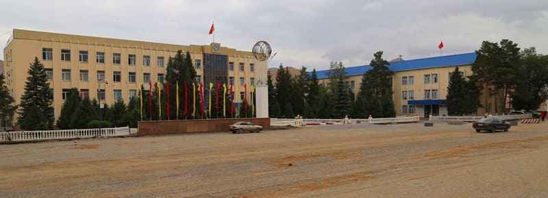
At the end of the Kochkor Valley is the village of Kochkor. Lunch at a local café. A visit to the Osmonaaly Sydyk Uulu Kochkor Regional History Museum.
Transfer: Kochkor – Kubakty Pass, 2,161 meters above sea level (25 km).
From Kochkor, our route heads northeast. The Kochkor River valley ends, and we enter the narrow gorge of the Chu River, formed by the Karatau Mountains to the east and the Kuvaki Mountains to the west. Soon, one of the roads turns east toward the village of Ottuk and further onto the southern shore of Lake Issyk-Kul.
We turn left and soon stop at a small platform offering one of the most beautiful views of the Orto-Tokoy Reservoir, formed by the Chu River. The river's waters settle in the reservoir and continue their flow through the Boom Gorge and further into the northern steppes of Kazakhstan.
Transfer: Kubakty Pass – Boom Gorge – the villages of Kemin, Tokmok, Kant – Bishkek (164 km).
After the Boom Gorge, our route heads west. Arrival in Bishkek. End of the tour.
Note.
** Walking tour to Lake Kel-Suu.
Those who wish can order horses for a horseback ride:
horseback riding - $ 20 per person.
boat ride on Lake Kel-Suu - $ 15 per person.
Note:
Author program of Alexander Petrov. Copying and introduction from sanction of author.
Photos by:
Alexander Petrov